jaster220
-
Posts
12212 -
Joined
-
Last visited
-
Days Won
59
Everything posted by jaster220
-

DECEMBER 2023 Observations and Discussion
jaster220 replied to Grizzcoat's topic in East of the Rockies
"Kinda reminds me of the intense punch with that SW at Halloween" Remember that MESO Low at the bottom of Lake Michigan?? It's like deja-vu, all over again (I'd take notes on this you LRC trackers out there)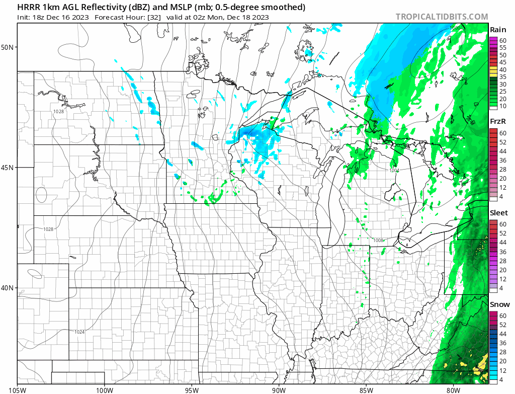
-
DECEMBER 2023 Observations and Discussion
jaster220 replied to Grizzcoat's topic in East of the Rockies
Arctic frontal blasts are pretty cool in their own short-duration way and I wouldn't turn one down at this point. But I have had horrible luck in missing out lately from every direction. -
DECEMBER 2023 Observations and Discussion
jaster220 replied to Grizzcoat's topic in East of the Rockies
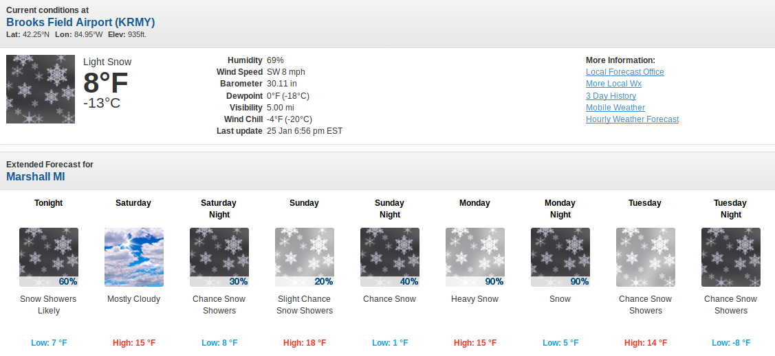
Was at the new place yesterday and there are still plow piles at all parking lots. My wife was hoping to actually see snow OTG like the last three times I was in the Northland. I was actually thankful to not be dealing with the slippery roads this time. -
DECEMBER 2023 Observations and Discussion
jaster220 replied to Grizzcoat's topic in East of the Rockies
Kinda reminds me of the intense punch with that SW at Halloween. And yeah, I will take blustery w/mood flakes vs continued snoozefest. DTX Expect ongoing rain showers to turn to a rain-snow mix over the course of the morning before turning to all snow by afternoon/early evening. Accumulations will be minimal due to the light precip intensities. Area of potential exception could be the eastern Thumb as lake effect ramps once the core of the arctic airmass settles over the region late Monday. This will be highly sensitive to the exact wind direction, ie true northwest vs more north-northwesterly component, with better chances to be clipped by bands the more northerly wind component there is. Gusty winds continue to look likely for Monday across the area as a deepening mixed boundary layer within the CAA regime supports gusts in the 35-40mph range, potentially stronger in the Thumb particularly along the lakeshore. -
DECEMBER 2023 Observations and Discussion
jaster220 replied to Grizzcoat's topic in East of the Rockies
Welcome to: 1) The Plains 2) Split flow regimes 3) El Nino winters in the north -
DECEMBER 2023 Observations and Discussion
jaster220 replied to Grizzcoat's topic in East of the Rockies
While '84 did not flip with a CAT-5 bliz like '98, it also ranks as one of the all-time winter season "flip the script" events for Michigan. Just looked at GRR and FNT and there were a couple of brief snows that Dec, but mostly an AN mild and low-snow month. Then the New Years Eve system was the first shot fired of a 6-week volley of winter's best which led to the amazing snow depths captured for my avatar image. Could we see something (anything) like that?? -
DECEMBER 2023 Observations and Discussion
jaster220 replied to Grizzcoat's topic in East of the Rockies
Day AFTER I move. Yep, works for me too, lol.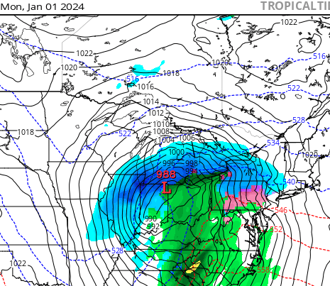
-
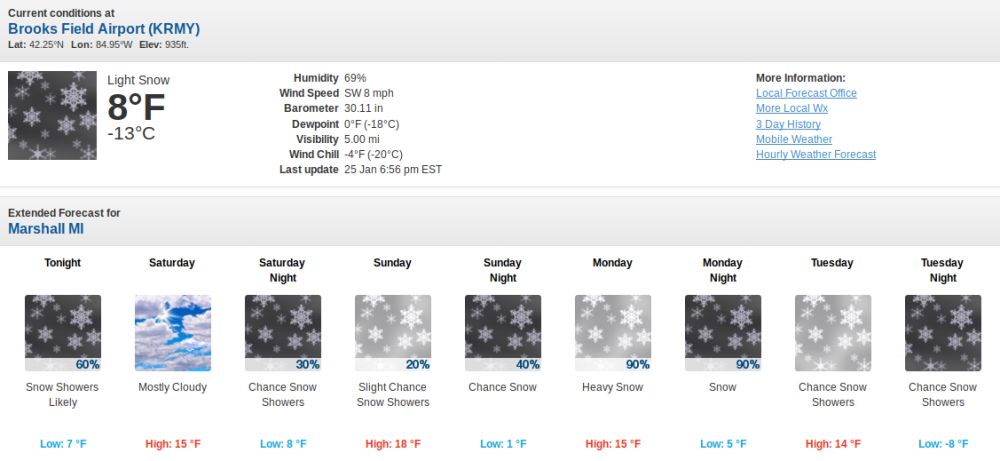
ORD Looks like Monday could be a brief taste of winter for some in the MW/GL's Since moving to Detroit, it's like I've almost forgotten what a real-deal winter stretch is like. From 2019:
-
-
DECEMBER 2023 Observations and Discussion
jaster220 replied to Grizzcoat's topic in East of the Rockies
GFS pretty aggressive with the brief arctic punch. This would certainly trigger the still warm GL's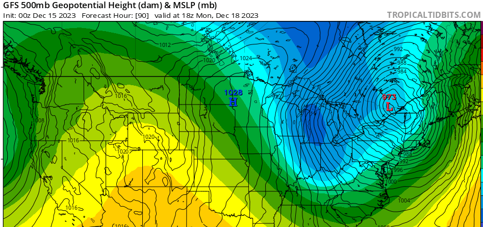
-
DECEMBER 2023 Observations and Discussion
jaster220 replied to Grizzcoat's topic in East of the Rockies
My memory of that storm. I was living in NWMI at the time. It was a bright almost cloudless sunny day and my car radio is interrupted by the EAS buzz tone. I'm thinking to myself "what could this possibly be for" since there was like zero anything going on with the weather in NMI at the time. Tone was followed by the NWS saying they were tracking a potentially crippling snowstorm and depending whether it tracked west of the Appalachians or more east, it could be hitting lower Michigan. Strangest wx alert of my life. Would have been so cool if actually hit us. It is the only time I've ever heard the EAS used for a snowstorm, and there have been a few legit blizzards since '92 ofc. -
DECEMBER 2023 Observations and Discussion
jaster220 replied to Grizzcoat's topic in East of the Rockies
@Hoosier Ricky is onboard for yby to maybe score some flakes -
DECEMBER 2023 Observations and Discussion
jaster220 replied to Grizzcoat's topic in East of the Rockies
I wish the ICON could win this one. 18z seems to show quite a bit of backside moisture in the form of snow. I believe it is picking up on a Huron enhancement that DTX was alluding to in their overnight AFD. NAM 12k at h84 is about as dry on the backside as could be.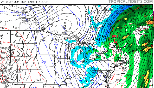
-
DECEMBER 2023 Observations and Discussion
jaster220 replied to Grizzcoat's topic in East of the Rockies
So how is this NOT you?? "A handful 12z ensembles, namely the ECMWF and CMC, have jumped towards a snowier solution across western Minnesota through the Twin Cities." -
DECEMBER 2023 Observations and Discussion
jaster220 replied to Grizzcoat's topic in East of the Rockies
Seems like 12z Euro would be threatening some non-tropical Dec low-barometer readings for way down there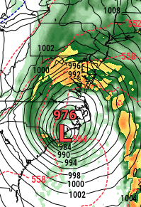
-
DECEMBER 2023 Observations and Discussion
jaster220 replied to Grizzcoat's topic in East of the Rockies
Really think that's just the way to go this season. Models are trash over-hyping any phase potential just to trend non/late phased. (sigh) -
DECEMBER 2023 Observations and Discussion
jaster220 replied to Grizzcoat's topic in East of the Rockies
Yeah, but didn't you already get a big storm? Thought Topeka was like ground-zero back in late November? -
DECEMBER 2023 Observations and Discussion
jaster220 replied to Grizzcoat's topic in East of the Rockies
Means nothing at this range, but the ICON shows much more precip back in the cold side including lake effect/enhancement for many parts of the GLs.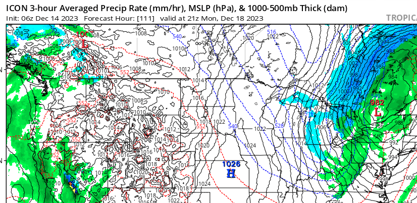
-
DECEMBER 2023 Observations and Discussion
jaster220 replied to Grizzcoat's topic in East of the Rockies
And I'd almost go so far as to say, that if we do see a massive flood of polar air at some point (see Russia today), I would think another Feb 1899 scenario isn't totally unrealistic. -
DECEMBER 2023 Observations and Discussion
jaster220 replied to Grizzcoat's topic in East of the Rockies
DTX- Still, the exact timing of the infusion of cold air and position of the deformation axis remains uncertain as we sort out the interaction of the 3 strong upper level waves/troughs (Missouri/northern Florida/Central Canada). Since we are 0 for 2 on these phaser scenarios, we should wait until we can see the white's of it's eyes before pulling the trigger on any thread! Could just be another in a series of teases, or it could actually trend back east and really then only @chescowxman would be interested in a thread, lol. -
DECEMBER 2023 Observations and Discussion
jaster220 replied to Grizzcoat's topic in East of the Rockies
was seeing/thinking that exact thing yesterday. Would not surprise me in the least that we something along those lines this winter. DTX However, amplified upper level ridge arching northwest through the Great Basin into Pacific Northwest will allow a strong shortwave and buckling of the Polar Jet to emerge as we end the Weekend into early Next Week. The trend is to link up and merge with the strong storm system over the southeastern United States, and a track along or west of the spine of Appalachians can no longer be ruled out (see 00z GFS/EURO) -
DECEMBER 2023 Observations and Discussion
jaster220 replied to Grizzcoat's topic in East of the Rockies
I figured that region of SONT just east of here would be set to score at some point. Not sure they will get much accumulation with the warmth of this system tho. Another dynamic system wasted on the shoulder seasons.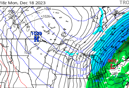
-
DECEMBER 2023 Observations and Discussion
jaster220 replied to Grizzcoat's topic in East of the Rockies
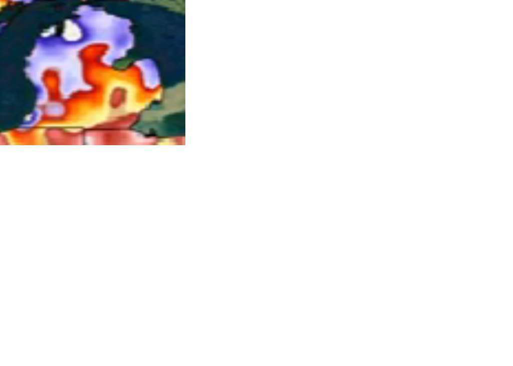
These graphics drive me nuts when it's a tangled web like that. And what is with so many colors. I thought it was current month = black, and new month is a color. Can you break it down since I can't zoom up on your attachment very much at all. -
DECEMBER 2023 Observations and Discussion
jaster220 replied to Grizzcoat's topic in East of the Rockies
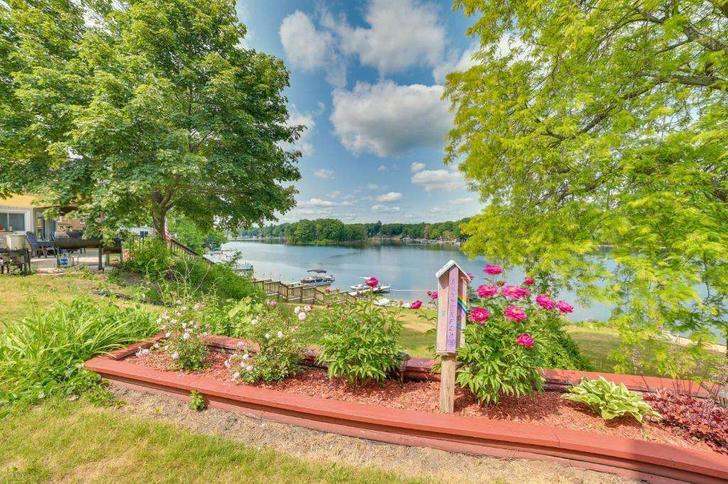
Many thanks amigo. Going to be trying out the lakeside lifestyle for the first time. (sample pic off the web, but our condo is on this lake)
-
DECEMBER 2023 Observations and Discussion
jaster220 replied to Grizzcoat's topic in East of the Rockies
Always seems darkest before the dawn