


Thundersnow12
-
Posts
14 -
Joined
-
Last visited
Everything posted by Thundersnow12
-
It was run set of runs..it will change. Also, if you live by the models, you'll die by the models when you talk about "staring at the models". Actually forecast. The model is just spitting out stuff. This is what in short, separates TV mets from the NWS pros. TV mets look at exactly model output and take it to the bank and usually die by it since there is never going to be a perfect prog. NWS mets actually forecast. They are take what is given to them by the models and then use their own knowledge and continue on. I'd bet there probably isn't a TV met out there besides a select few that could actually write an NWS AFD.
-
Nothing? Dude we're 84hrs out. What do you expect? Every model to be locked in? It's fast moving, open wave along a baroclinic zone that right now is currently not getting sampled south of Alaska over the nrn pac. Given those factors and what the models are currently showing, I'd say there is a decent consensus right now
-
It wont. The combination of strong WAA, fronto banding, and an extremely deep DGZ all lead to the threat of warning criteria amounts
-
This snowfall map actually looks better (even if slightly overdone) compared to the WxBell snowfall maps because the ratios will be sky high given the DGZ depth and WxBell snowfall maps are assuming 10:1 which is way too low
-
Christmas Eve Potential Major Winter Storm
Thundersnow12 replied to Tom's topic in East of the Rockies
Last 3 runs of the GFS with all of the ensemble member tracks showing the growing consensus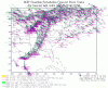
-
Christmas Eve Potential Major Winter Storm
Thundersnow12 replied to Tom's topic in East of the Rockies
You will not see the warm tongue on the text products because it's above 850mb. Check out some fcst soundings -
December 2014 Observations and Discussion
Thundersnow12 replied to Tom's topic in East of the Rockies
Yeah just can't generate much snow at all like you'd think it would with all the warm air being pulled into the circulation. West of say a GRB-MKE-IKK line stay cold enough for snow but the precip can't get this far west as the main precip slug moves almost due north. Sfc low bottoms out at 961mb. The wave rounding the base of the trof digs so far south allowing for warm air to advect northward so you get a situation where your strongest CAA is coming in and wrapping around and your WAA is getting pulled up and around to the north of the sfc low -
December 2014 Observations and Discussion
Thundersnow12 replied to Tom's topic in East of the Rockies
The 12z Euro EPS control run has three cutters. SE ridge really flexing its muscles -
December 2014 Observations and Discussion
Thundersnow12 replied to Tom's topic in East of the Rockies
But still ends up further SE of the 0z ensemble mean -
December 2014 Observations and Discussion
Thundersnow12 replied to Tom's topic in East of the Rockies
Those are the 0z run images. This is what I like to see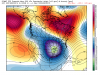
-
December 2014 Observations and Discussion
Thundersnow12 replied to Tom's topic in East of the Rockies
The GFS continues to have runs here and there where it really tries to get this system going on the 19th/20th but can't fully do it. The wave most of the time is an open wave and it's moving quicker. A few runs for a few frames try to close it off at 500mb but it just gets too strung out and can't intensify like we want it to. The strong WAA via the LLJ in the WCB early on over the plains will be plenty enough to generate a good slug of precip up and over the front to get some snow it looks like in KS/MO as the GFS shows but maintaining any sort of organization as it moves ENE might be tough as the wave just looks to flat with no intensification signals right now. Several Euro ensemble members were amped up and NW of the op and the ensemble mean so we'll see. -
December 2014 Observations and Discussion
Thundersnow12 replied to Tom's topic in East of the Rockies
Yeah and it COULD snow 2 feet of snow on Christmas. Just because someone says it could doesn't make it okay. There is a difference between crying wolf for one specific day because one models says so and looking at the overall pattern and saying the threat will be heightened for significant cyclogenesis during a several week period. -
December 2014 Observations and Discussion
Thundersnow12 replied to Tom's topic in East of the Rockies
Is he looking into a crystal ball? There is no way to believe or even know something like that 13 days away. C'mon. All you can say is some models are showing the chances for some big systems given the overall synoptic pattern that will possibly come to fruition over the coming weeks looking at the ensembles. -
December 2014 Observations and Discussion
Thundersnow12 replied to Tom's topic in East of the Rockies
The CFSv2 images are pretty interesting to say the least, you can see where baroclinic zone would be located and with a dominant SE ridge, the storm track could become quite active with multiple storms for a several week period.


