Omegaraptor
-
Posts
7116 -
Joined
-
Last visited
-
Days Won
4
Everything posted by Omegaraptor
-

October 2018 Weather in the Pacific Northwest
Omegaraptor replied to Tyler Mode's topic in West of the Rockies
Heavy storm incoming. Looks like Portland could get up to 1.5” today. Sustained heavy rain after 2PM. Up to 0.2” per hour - not typical PNW rain at all. There is a gale warning on the coast, also starting at 2PM. -
October 2018 Weather in the Pacific Northwest
Omegaraptor replied to Tyler Mode's topic in West of the Rockies
Fun fact: the warmest Halloween on record in Portland was 71ºF. This record was set, surprisingly enough, in 1954, the year with the coldest recorded summer in Portland. That year was a true stinker of a "summer". The highest temperature recorded that year was an 86ºF on... May 17. In July and August 1954, almost 1 in 3 days failed to break 70. The highest temperature recorded in the June-September period was 83ºF, and only six days in the 80s were recorded in those four months. -
October 2018 Weather in the Pacific Northwest
Omegaraptor replied to Tyler Mode's topic in West of the Rockies
The Blob also faded after the 2016-17 winter and we got a relatively mild 2017-18 winter (remember when it was predicted to be a record cold one?) followed by a record hot summer. -
October 2018 Weather in the Pacific Northwest
Omegaraptor replied to Tyler Mode's topic in West of the Rockies
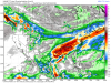
Forecasts are saying that a thunderstorm might happen on Sunday. Not sure of the actual chances of this happening. I’m just happy that ski season is coming. No rain, no snow in the Cascades. -
October 2018 Weather in the Pacific Northwest
Omegaraptor replied to Tyler Mode's topic in West of the Rockies
Unusually warm morning for this time of year. 54 in Portland, 58 in Seattle. What’s even weirder is that 58 is Seattle’s high today, and it’s going to drop to 54 in mid-day. -
October 2018 Weather in the Pacific Northwest
Omegaraptor replied to Tyler Mode's topic in West of the Rockies
40.47” by November is wetter than normal. Remember that 2016-17 was one of the wettest winters on record. But yeah, 16.93” is way under normal as well. -
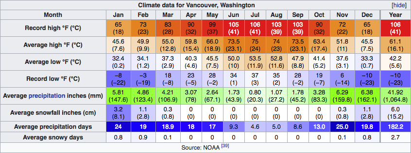
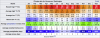
While looking at Wikipedia weather data, I notice something off about Vancouver, WA. Not sure if this is just Wikipedia being inaccurate, but here is the Portland table: and here is the Vancouver, WA table: Assuming Vancouver uses the Pearson Field, the stations are less than five miles apart. Yet somehow, Portland averages 3ºF warmer year round, and 5ºF warmer in the summer. Even SeaTac airport, right next to a cold body of water, somehow gets higher average summer highs than Vancouver, WA. Vancouver somehow gets 182 days with measurable precipitation every year, more than Seaside on the coast and 28 more than Portland. It also somehow gets 6 more inches of rain every year. Something is fishy here. The data claims to be NOAA, but what's going on? Any other stations with weird data like this?
-
October 2018 Weather in the Pacific Northwest
Omegaraptor replied to Tyler Mode's topic in West of the Rockies
Thank you. Thank you. This makes complete sense. -
October 2018 Weather in the Pacific Northwest
Omegaraptor replied to Tyler Mode's topic in West of the Rockies
And I have a question. I’m not an expert on PNW weather, but I know a good deal about it. Why does the Portland area get so little fog despite being in a valley? I can understand Seattle’s fog because it’s right next to a cold body of water. The Southern Willamette Valley, Rogue Valley, and California’s Central Valley are all capable of getting heavy fog, but Portland somehow misses out on it. Is there an explanation? Edit: Well, looks like there’s a bit of fog in East Portland, but Washington County is missing out. -
October 2018 Weather in the Pacific Northwest
Omegaraptor replied to Tyler Mode's topic in West of the Rockies
And this is why I greatly prefer to use the European 1mm/0.04in threshold when counting precipitation days. Localized or negligible precipitation / morning dew gets counted out. Using this threshold, Portland and Seattle both have about 120 rain days per year. -
October 2018 Weather in the Pacific Northwest
Omegaraptor replied to Tyler Mode's topic in West of the Rockies
43 here this morning. 74 predicted later today. -
October 2018 Weather in the Pacific Northwest
Omegaraptor replied to Tyler Mode's topic in West of the Rockies
Has anyone been getting hard frosts yet? My area came close today. -
October 2018 Weather in the Pacific Northwest
Omegaraptor replied to Tyler Mode's topic in West of the Rockies
Odd. My station is overreporting. -
October 2018 Weather in the Pacific Northwest
Omegaraptor replied to Tyler Mode's topic in West of the Rockies
54 and clear in Portland. -
October 2018 Weather in the Pacific Northwest
Omegaraptor replied to Tyler Mode's topic in West of the Rockies
Tillamook, of all places, hit 80 - impressive! We hit around 77 here. Just shy of breaking the record for the date at 79. -
October 2018 Weather in the Pacific Northwest
Omegaraptor replied to Tyler Mode's topic in West of the Rockies
That’s why I don’t look at pre-1940 records. The methods back then were more primitive. -
October 2018 Weather in the Pacific Northwest
Omegaraptor replied to Tyler Mode's topic in West of the Rockies
20” in one month 1882-83... wow! I don’t normally look at records before 1940, but some weird stuff can be found before then. Downtown Portland records started in 1871, but it hit 104 in Seattle in 1870 and it wasn’t even the hottest part of the day. It could have easily been 110 or higher in Portland that day - in 1870. But IMO Portland will probably break the 107 record and possibly even hit 110 in the next couple of decades. 2017 came very close. -
October 2018 Weather in the Pacific Northwest
Omegaraptor replied to Tyler Mode's topic in West of the Rockies
2016/17 got a ridiculous amount of rain days in October (I think 28/31 or something like that?) IMO there is almost no chance that this winter will come even close to 2016-17. That winter started early and lasted long. IMO this one will be slightly warmer than average, but we’ll see. -
October 2018 Weather in the Pacific Northwest
Omegaraptor replied to Tyler Mode's topic in West of the Rockies
Currently 48° here. Parts of Oregon are ridiculous, especially Eugene which is experiencing a hard frost and a diurnal range of over 40° today. Actually, the entire stretch from the southern Willamette Valley to the Klamath Mountains west of Redding has insane diurnal ranges. Same goes east of the Cascades from Sunriver area to Lassen NP. These both continue further south, it’s just where my idea of the PNW ends. -
October 2018 Weather in the Pacific Northwest
Omegaraptor replied to Tyler Mode's topic in West of the Rockies
43 here. Clear skies with some orographic lift on the West Hills. -
October 2018 Weather in the Pacific Northwest
Omegaraptor replied to Tyler Mode's topic in West of the Rockies
Latest 80°F on record in Portland is 10/21. Even if this high pressure system strengthens further, it probably won’t be the latest 80°F on record, but it will sure be close. High today was 66ºF and low was 43ºF. Mostly sunny conditions. -
October 2018 Weather in the Pacific Northwest
Omegaraptor replied to Tyler Mode's topic in West of the Rockies
This high pressure system just keeps upgrading. Portland could see a week of 70s - even the Snoqualmie Valley where TT-SEA is could be seeing 70s next week. According to Wunderground the sun and blowtorching will last up to two weeks. -
October 2018 Weather in the Pacific Northwest
Omegaraptor replied to Tyler Mode's topic in West of the Rockies
Cloudy and 54 this morning. Nighttime lows should drop a bit with this streak of sun. I think the first frost will come in late November. -
October 2018 Weather in the Pacific Northwest
Omegaraptor replied to Tyler Mode's topic in West of the Rockies
High today: 62 Low today: 52 Overcast 0.07 inches of rainfall Is it just me, or does Washington County receive less rainfall than other parts of the Portland metro? The nearby station could be bugged but I didn't see much rain, if any rain, today. Meanwhile some of you are reporting half an inch today. Never mind, Boring gets more rain than Portland (near the foothills). Washington County is similar to Portland rainfall-wise. -
October 2018 Weather in the Pacific Northwest
Omegaraptor replied to Tyler Mode's topic in West of the Rockies
Only three Novembers since 1940 have recorded a 70º using airport data. I'm not saying it's impossible (last year recorded a 71º on 10/28) but it's certainly very late in the year and not exactly likely to happen. It would surprise me for sure. Also, the highest number of 70s recorded in a single November is one.