KTPmidMO
-
Posts
96 -
Joined
-
Last visited
Everything posted by KTPmidMO
-
I just want a couple inches of snow, I'll take it! lol
-
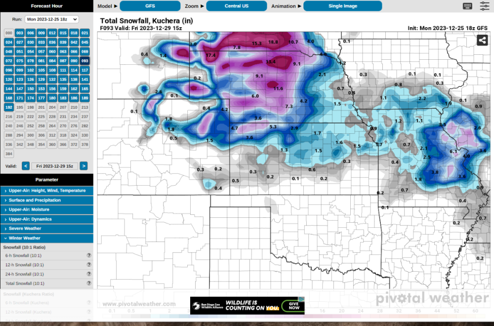
I'm liking what I'm starting to see on the models here in Missouri, keep it coming please! I wonder what kind of snow:liquid ratio there will be. Kuchera seems to be pointing at a 8:1. Bump it up to a 10:1 and it looks even more beautiful here in Missouri.
-
Thank you!
-
Can anyone post the 18z ECMWF?
-
Exactly my thoughts Clinton.
-
Interesting post from a local guy in St. louis who is pretty spot on with what he puts out there. Like he says, just something to watch right now because it was only one run really.. But interesting nonetheless for us Missouri/Illinois folks.

-
What's this showing for Wednesday/Thursday timeframe for Missouri and Illinois now? 18z GFS
-
Also congrats to everyone that is gonna get smashed with this thing on Christmas, that's awesome!!
-
12z NAM looking quite a bit further south and east with the snow field at hour 27?
-
DECEMBER 2023 Observations and Discussion
KTPmidMO replied to Grizzcoat's topic in East of the Rockies
Flying into Columbia would put you a lot closer to the Ozarks compared to St. Louis. Would be about half the drive from Columbia. But, COU will most likely be more expensive than STL or KCI. -
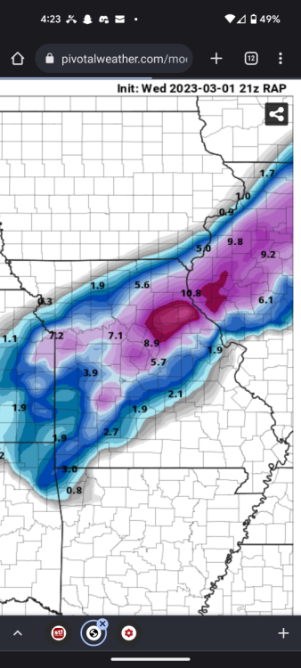
21z RAP..
-
18z NAM and 3km NAM had a noticeable SW shift from 12z. Do you think that is correct and will that continue? Also, How is there such a difference between what the Euro/NAM show compared to the GFS/GEM? Euro/NAM show I big swath of snow in Missouri and GFS/GEM literally have nothing in Missouri. And we are the day before the storm!!! Its almost comical how different they are.
-
Do you have access to all the Euro ensembles?
-
Can you post the GFS ensembles here for me? Thanks
-
Once again, the snow is going to just barely miss me and I'm probably going to end up all rain...*sigh*... Getting the right ingredients to come together for a good snow has been hard to come by here in central Missouri. This winter has been terrible.. I've either been missed just to my north or just to my south every time. My biggest snowfall this year has been 3.5 inches and the couple other storms have just been a 1 or 2 incher. Way below average for snowfall. Congratulations to all getting in on some good snow the past few weeks and hope you get hit good with this one as well. Im done with this winter, bring on spring...
-
Does anyone here have access to all the ensemble members for the GEFS and can post them? Please and thank you.
-
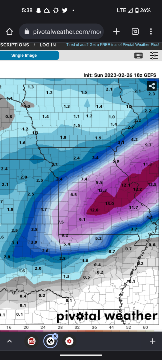
18z GEFS 10:1 mean. Nice hit for my area. Not sure the last time I've seen the GEFS put out that high of totals for my area. Hopefully the trend continues into this week. This winter has been a little bit of a dud in my area.

-
Where did you start it? I'm not seeing it for some reason.
-
NAM completely got this one wrong for my area in central Missouri. The Euro was the one that nailed it for my area here followed by the UKMET doing a good job as well. GFS did an ok job. Not sure about other regions though.
-
Thanks!
-
@ClintonCan you post ensemble members when able of the 00z GEFS currently running?
-
Do you have a snapshot of the 500MB of what the models were predicting the day or 2 prior to the storm back in November? Would be interesting to see a snapshot of what the models were predicting then compared to a snapshot like you had above of the actual storm.
-
Does anyone have access to all the ensemble members for the 18z GEFS and can post here? thanks!
-
That low looks more NW than what is forecast with the storm this go around. Wonder what will happen exactly. hmm
-
NAM is much further NW with the snow field! Will the NAM be the only that does that, or will other models follow suit?