Meatyorologist
-
Posts
8938 -
Joined
-
Last visited
-
Days Won
13
Everything posted by Meatyorologist
-
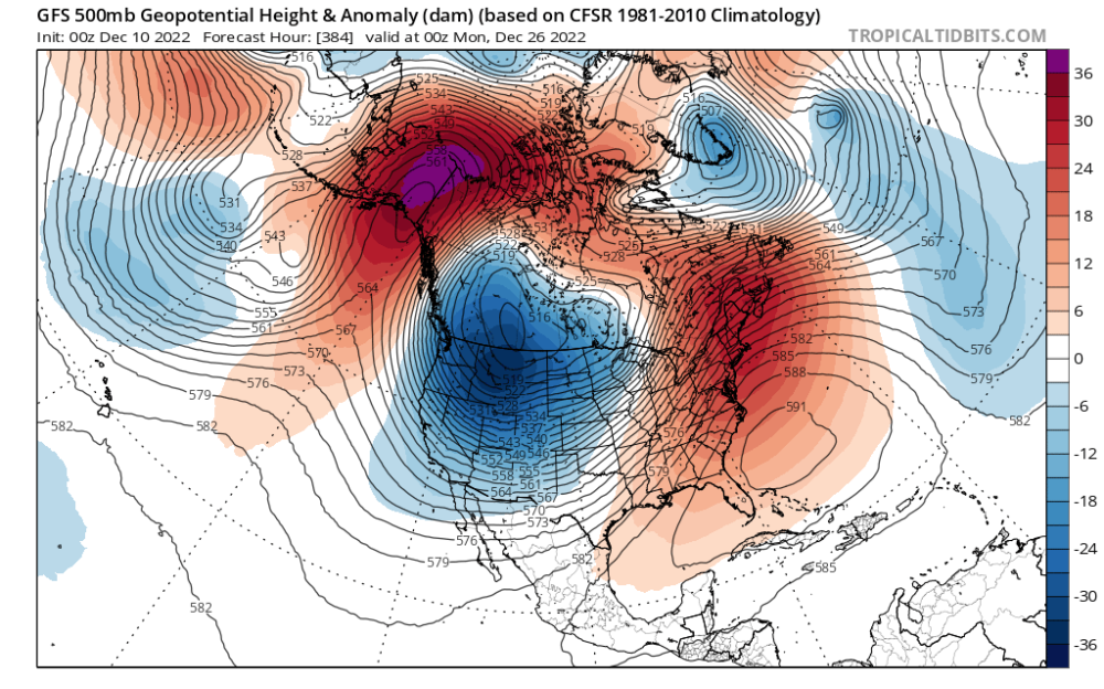
 The shortwaves that spawn our Arctic troughs aren't going to be resolved by any model that far out, let alone appear with enough consistency to show on an ensemble mean. It's a smoothed average. Interpret it as such!
 -
What does this even mean
-
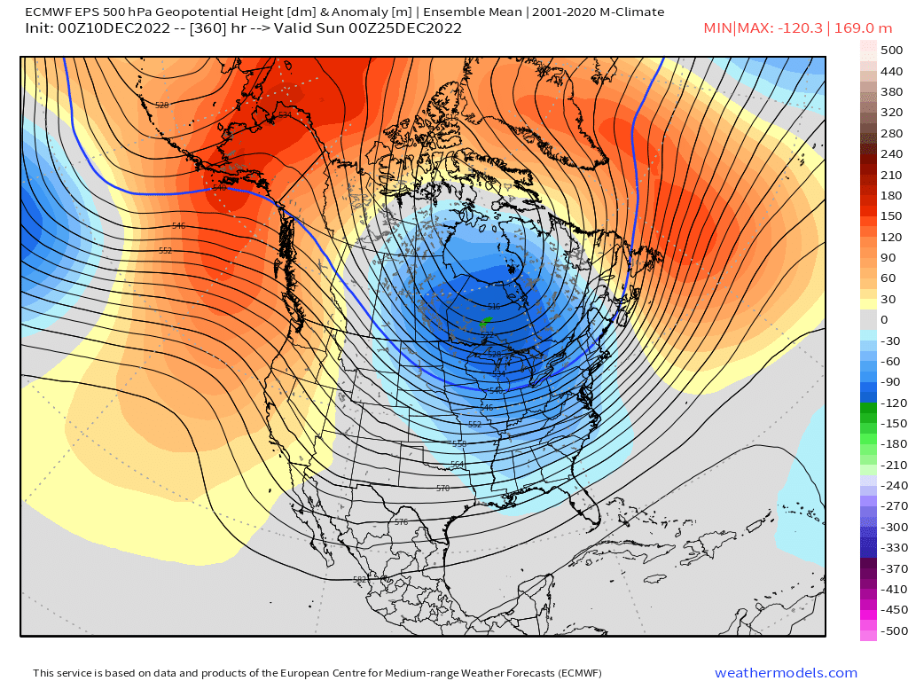
-EPO, -NAO, northerly flow and continental influence on the afternoon of Christmas eve. There were three puke reacts to this post.

-
People tonight are really just seeing red blobs and crying lol. Looks like the forum is in typical form! AK blocking. -NAO still there. The pieces are exactly in the right place, the fidelity is just low. The maps I'm seeing are like two minor tweaks away from a prolonged Arctic snap. Hell, it's already very continental. If I'm a seasoned meteorologist in the PNW seeing these maps, even (especially) the 00z EPS, I'm checking my pipes. Perspective has never been this forum's strong suit, but it does get a little grating seeing all the ween when there is just about nothing wrong. Most of the night I've been peeking at models while doing other things, and my main reactions have been "that's an epic GFS run", and "oh, that's a little warmer. It's far out and wobbling around. Just some long range noise." If I had just read this forum at face value without my unfiltered interpretation, I would have expected +10C 850s and BSF with a roided Aleutian low.
-
..........we aren't?
-
@TigerWoodsLibido
-
So it's been about twice as warm as it has been cold. Sounds about right.
-
Bumping this again because this is an s tier post and is exactly the kind of stuff we want here. Adds a bit of context too to the intense nature of the last year. Very anomalous... Far more in the warm direction thus far. The GFS might actually even the score a tad.
-
DeepFriedEgg??!
-
No SSW either. Just pure tropical forcing. That is a beauty of a weather pattern. I would not trade this run in for anything else. The 06z will probably be worse based simply on the fact that our weather patterns can only get so good.
-
Un fuggin real. The maximally perfect pattern. Everything from the upstream wavedriving in SE Asia to the sprawling SE US ridge. The pure essence of -ENSO/+QBO. As good as it can get.
-
I see no end to that weather pattern on the GFS. Kona low is reinforced and the block would be as well. A dream weather pattern. Closer to January 1950 than February 2019.
-
This is probably one of the biggest stories of the winter.
-
Long range GFS is every weenie's wet dream.
-
I've always been told it's the best example of a true "Siberian Express", with some funky endogenous AK air tagged alongside. Looking at Euro reanalysis I guess that airmass' upstream origins were singing with the Soviets, but ultimately it was a fairly patriotic blast. Was pretty nutty how the blocking episode manifested out of what appeared to be an infuriating +EPO purgatory.
-
Genuinely my best guess. Hope I'm right!
-
The way a potent Siberian airmass rides the top of a building block and crashes into the area. Not an exact match but it's a close-ish comparison.
-
February 1989-style progression on the 00z GFS.
-
Cold air sinks. Cold airmasses literally tend towards inversions.
-
So fake. So disappointing. Some members here would start weeping.
-
That Euro run ends in an insane place. Hopefully something close to that comes to fruition.
-
At face falue that looks like it makes room for improvement down the line. Christmas will be very interesting this year.
-
I feel like we just throw the word 'trend' around here without knowing what it actually means lol
-
Mannnn that torchy Canada bums me out. No real Arctic air to tap into for at least 72 hours beyond that frame.
-
Heights are lower in Missouri than the Canadian Archipelago. A completely inverted midlatitude Troposphere!