


Meatyorologist
-
Posts
9026 -
Joined
-
Last visited
-
Days Won
13
Everything posted by Meatyorologist
-

November 2022 PNW weather Discussion. #NoRidgeNovember
Meatyorologist replied to Iceresistance's topic in West of the Rockies
Deformation banding -
November 2022 PNW weather Discussion. #NoRidgeNovember
Meatyorologist replied to Iceresistance's topic in West of the Rockies
That forecast actually verified nicely at my place, but the windswept snow brought crazy drifting almost two feet deep in parts of the yard. -
November 2022 PNW weather Discussion. #NoRidgeNovember
Meatyorologist replied to Iceresistance's topic in West of the Rockies
That thing does not do well with deformation snowfall at all. Consistently and comically underdoes it. If it were to be believed, I would have received 3" in Feb 2019. Toss it. -
November 2022 PNW weather Discussion. #NoRidgeNovember
Meatyorologist replied to Iceresistance's topic in West of the Rockies
Posting about this in the twitter groupchat... What is offshore right now is convection enhanced by divergence aloft. That will stall and weaken gradually as it meanders onshore, if it even makes it to land. What the global models are so happy about tomorrow morning is a deformation band forming over the sound. That is a separate feature, as Jim has pointed out. That is the best chance for accumulating snowfall Seattle northward. -
November 2022 PNW weather Discussion. #NoRidgeNovember
Meatyorologist replied to Iceresistance's topic in West of the Rockies
Stellar cloud streets -
November 2022 PNW weather Discussion. #NoRidgeNovember
Meatyorologist replied to Iceresistance's topic in West of the Rockies
Best Dec -NAO in 12 years. Serious stuff. -
November 2022 PNW weather Discussion. #NoRidgeNovember
Meatyorologist replied to Iceresistance's topic in West of the Rockies
Even from a neutral perspective, that is a lot of Arctic blocking being depicted and there is opportunity written all over this. -
November 2022 PNW weather Discussion. #NoRidgeNovember
Meatyorologist replied to Iceresistance's topic in West of the Rockies
Not sure if this was posted. From last night's EPS.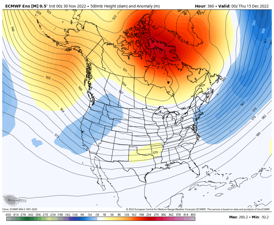
-
November 2022 PNW weather Discussion. #NoRidgeNovember
Meatyorologist replied to Iceresistance's topic in West of the Rockies
Offshore radar is juicy. I'm hoping! -
November 2022 PNW weather Discussion. #NoRidgeNovember
Meatyorologist replied to Iceresistance's topic in West of the Rockies
das some nice cyclogenesis -
November 2022 PNW weather Discussion. #NoRidgeNovember
Meatyorologist replied to Iceresistance's topic in West of the Rockies
NAM is definitley overdoing the sfc low. Entirely convection-driven and formed by the same bias that causes it to spawn mega-canes -
November 2022 PNW weather Discussion. #NoRidgeNovember
Meatyorologist replied to Iceresistance's topic in West of the Rockies
Rain/snow mix in downtown. -
November 2022 PNW weather Discussion. #NoRidgeNovember
Meatyorologist replied to Iceresistance's topic in West of the Rockies
Sad to see the south trend with tonight's system. Gonna be a nowcast situation regardless but I'm grateful for the snow we got last night. 0.75" at my place officially. Friday looks like a carbon copy of last night's storm but with more cold air and less moisture. May very well end up with the same totals when all is said and done. -
November 2022 PNW weather Discussion. #NoRidgeNovember
Meatyorologist replied to Iceresistance's topic in West of the Rockies
It's like the opposite of the N/S cutoff tonight! -
November 2022 PNW weather Discussion. #NoRidgeNovember
Meatyorologist replied to Iceresistance's topic in West of the Rockies
Incoming batch of precip has dragged the temps back down to 32F in many places around Seattle. Could get really heavy again. -
November 2022 PNW weather Discussion. #NoRidgeNovember
Meatyorologist replied to Iceresistance's topic in West of the Rockies
33F and moderate snow. Radar is blowing up again. Taking in the sights. Measured 0.5", after 0.25" melted this morning. -
November 2022 PNW weather Discussion. #NoRidgeNovember
Meatyorologist replied to Iceresistance's topic in West of the Rockies
Roads are covered and everything. Getting heavier. Unbelievable turn of events! I had no expectation of a changeover, let alone stickage! Evaporative cooling is crazy sometimes! -
November 2022 PNW weather Discussion. #NoRidgeNovember
Meatyorologist replied to Iceresistance's topic in West of the Rockies
UPDATE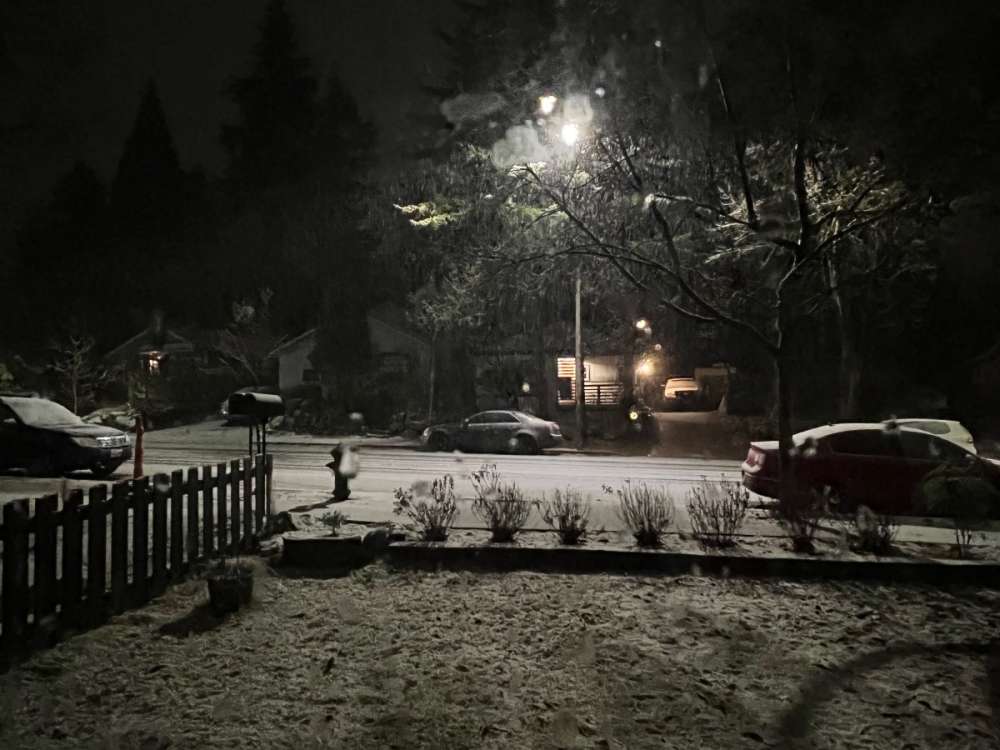
-
November 2022 PNW weather Discussion. #NoRidgeNovember
Meatyorologist replied to Iceresistance's topic in West of the Rockies
On the edge here. Could walk 20 mins north into heavy accumulating snow. 34F with an easterly breeze. -
November 2022 PNW weather Discussion. #NoRidgeNovember
Meatyorologist replied to Iceresistance's topic in West of the Rockies
Deformation bands usually end up larger, more north, and heavier than forecast. I'm just saying. Fully open to a bust and bare lawns. I am not the man above. But things look promising for at least an inch tomorrow night, in more conservative terms. -
November 2022 PNW weather Discussion. #NoRidgeNovember
Meatyorologist replied to Iceresistance's topic in West of the Rockies
I've seen this movie before. Actually reminds me of 1/10/17 for the PDX area in some respects, not to send the hype to a gazillion. But it shows the true potential. -
November 2022 PNW weather Discussion. #NoRidgeNovember
Meatyorologist replied to Iceresistance's topic in West of the Rockies
Only one possible react for this post -
November 2022 PNW weather Discussion. #NoRidgeNovember
Meatyorologist replied to Iceresistance's topic in West of the Rockies
If all else fails for north Seattle, it could very well be a bit snowy Friday! Lots to be excited about. Just about the best start to winter I could have hoped for. Oh, and those insane lows the GFS is spitting out? Sure, discount them for the metro areas, but outlying valleys and the cool spots would have no problem matching or outdoing those numbers if a good snowcover establishes itself tomorrow night. -
November 2022 PNW weather Discussion. #NoRidgeNovember
Meatyorologist replied to Iceresistance's topic in West of the Rockies
Just caught up on stuff. Thundersnow!!! Wow!!! Currently a wet non-sticking snow and a skiff on the grass from this morning. 34F with an east wind. Tomorrow night is rapidly evolving into something potentially very special for the Seattle area. Fellow 'Sounders, this could be not only the event of the week but if all things go right, we may be looking back on it as the event of the season. Lots of moisture to work with, stable, reliable dynamics, plenty of time to squeeze it all out, the temperatures to support it all as sticking snow, and actual precedents to compare it to (unlike today!) Of course it could all go south but the potential is great. I'm cautiously excited! -
November 2022 PNW weather Discussion. #NoRidgeNovember
Meatyorologist replied to Iceresistance's topic in West of the Rockies
GFS still erroneously aggressive with Cascade gap outflow, but temps will fall this evening at least Seattle north. Will it be enough for stickage, or even a switch back? We'll see! The sun is going down and getting less powerful, and precip is picking up.


