Meatyorologist
-
Posts
9014 -
Joined
-
Last visited
-
Days Won
13
Everything posted by Meatyorologist
-
KSEA up to 89F, now 1F ahead of yesterday
-
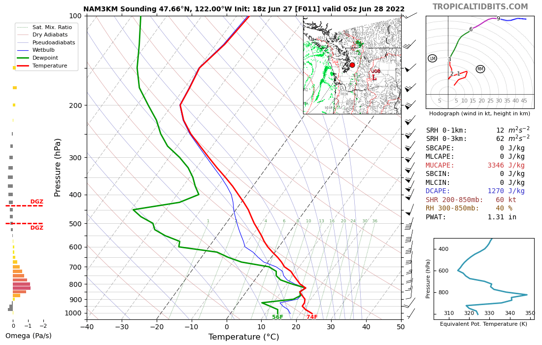
This might legitimately take the cake for the most unstable sounding I've ever seen here.

-

-
KSEA running -4F from yesterday on the 10am update.
-
Got down to 57F here. Will probably have a similar high to yesterday, which reached 91F here.
-
Yup
-
LR 06z GFS looks wonderful for Utah and western CO. They need the rain.
-
KSEA managed to dip barely below the inversion line right after sunrise, crashing to ~64F at 6am. Back up to 67F now.
-
Needles, CA yesterday recorded their first instance of precipitation on June 26th since records began in 1940, totaling 0.02"... after a high of 111F. Per NWS Seattle
-
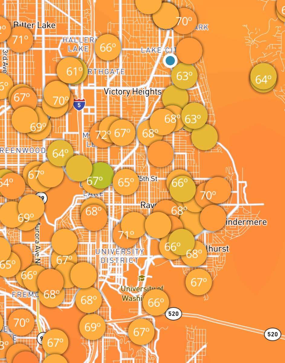
An island of yellow amidst a sea of orange. Love this little microclimate.
-
KSEA had a low of 67F yesterday morning. Good god. Meanwhile, it got down to 56F here in the Meadowbrook Valley. Currently 63F despite temps at the airport and much of the rest of the city remaining at 71F.
-
Will mean a warm night tho. KSEA will record a 57, book it
-
Even Tuesday will be one of those weirder summer days where clouds and showers increase throughout the day. Very well could have a noon high temperature. Or a midnight one if things don't cool off so quickly!
-
It's split into two camps, one that favors the occlusion band, and another that doesn't. The Euro and GFS mix things out and bring highs around 70, while the NAM, GEM/RGEM, and ICON wrap that occlusion band around, favoring highs in the low 60s with intermittent rainfall. My instincts tell me to blindly follow the Euro into oblivion, but it's not so simple. Occlusion bands are notoriously difficult to forecast, and meso models (including NAM and RGEM) tend to pick up on them a bit better than global scale models. I'm for now going to side with a mix between the two. I figure the Euro and GFS are underplaying this feature, while the meso models are also probably overvaluing its extent, and likely modeling the whole pattern transition and establishment a bit wrong compared to the other two big kahunas. I'll go with partly to mostly sunny and highs in the mid-upper 60s. For all the shit we give the Euro for consistently underestimating high temperatures, it may very well verify nicely on Wednesday. Just my two cents tho, and this is a complicated fcst with a 3 day lead time. Could be wrong in either direction. My previous post was addressing the reappearance of that occlusion feature after the GFS teased with it a few days ago. If it's reappearing now, there could be some validity to it. Or the GFS resolved some issue long ago w/ better data that the other models have yet to work out due to worse data/less resources.
-
Wednesday starting to look like quite the chilly day in the central Sound. Low level convergence w/ an occlusion-like feature wrapping around the parent low. Could be a drizzly day mostly spent in the 50s for Seattle. Sounds like amazing relief after this weekend.
-
I love talking about this kind of stuff so it's not a burden in the slightest And if there's anything I've learned over time, it's that I'm not nearly an expert by any means. Just starting out vector calc, literally the tinker toys of what I'll have to do in uni, and I feel like my eyes are melting. But it's very flattering
-
Not in Oregon, no. There will be no moisture left, unfortunately. There's a vague chance north of Olympia but the real threat will be relegated to the north Cascades into British Columbia.
-
-
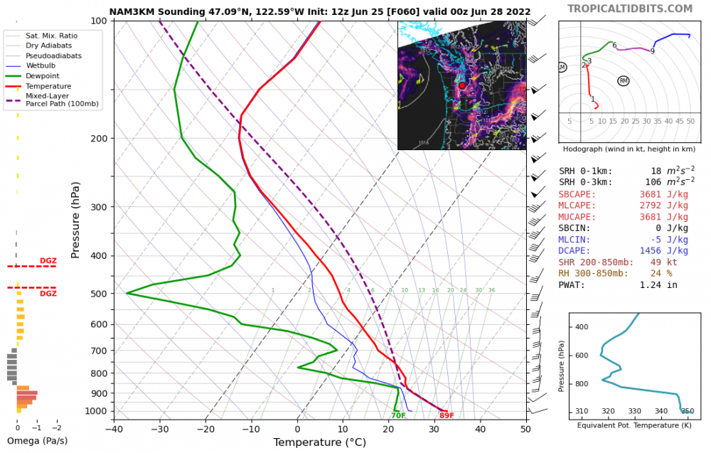
The dewpoint (DP) is the temperature at which water in the air begins to condense, or precipitate, out of the air, forming into clouds and dew/frost and rain/snow/hail. For instance, if the actual air temperature is 70F and the DP is 60F, and you lower the actual temperature to 60F, water will begin to condense out. And if you keep lowering the actual temperature below the dewpoint (60F), more and more water will be forced out of the air, exactly like water being wrung out of a squeezed sponge. (A side technical note, as you keep wringing out water like that, the DP will also drop in tandem with the air temp, since water was lost.) The dewpoint is essentially a measure of how much water is in the air. Humidity is how much water there is in the air, relative to the air temp. The NAM was predicting DP's in Seattle to be around 60F, while in actuality they were in the mid 40s. That kind of error is astronomically bad, and means gallons more water vapor per square meter of air. In a convective situation that would mean the difference between severe clear and a huge thunderstorm outbreak.
-
Holy shitt, the NAM verified *13F* too warm on DP's at KSEA. That is an ungodly error. It's not even a boundary situation either, this is a 13F error with the antecedent airmass.
-
Yeah SeaTac is a bad example for the majority of the city on afternoons like this... Except for my specific area, which is running an 89F, since we're sheltered from the sound breezes. Hotttt out there
-
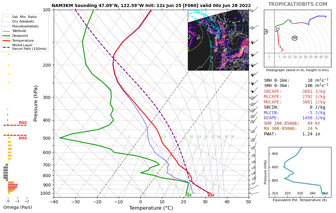
NAM is breaking my heart here.... This is very close to a giga outbreak but there's not enough lift.
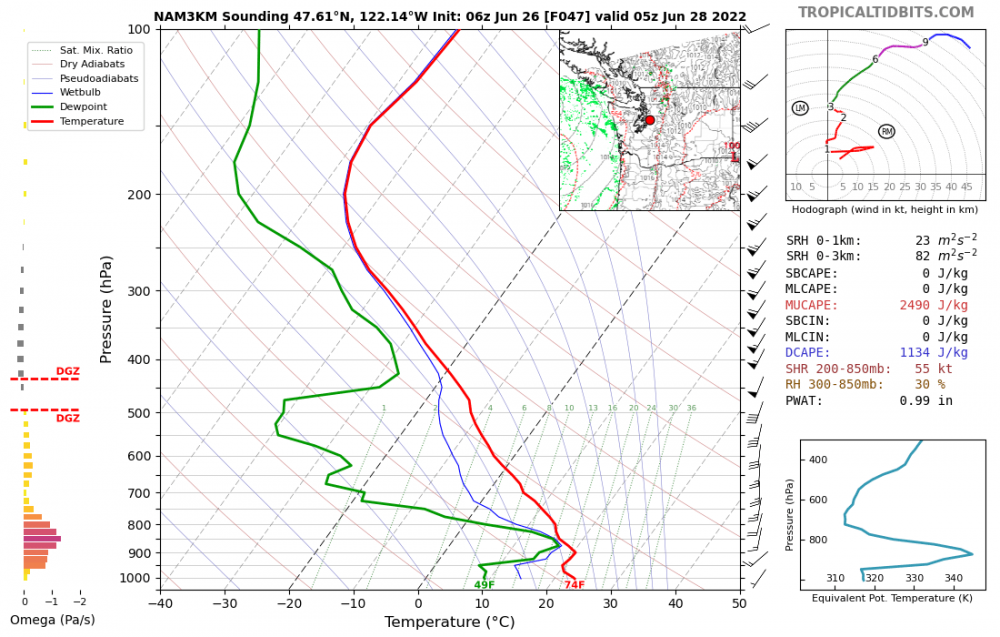
-
Dear NAM... What, and I mean seriously what, in the actual hell is this.
-
Already the first 80F day of the year for KSEA on the noon update. Should have no problem reaching 85F, probably a high around 87F
-
It's going to verify around 7-10F too cold. Bad, bad day for them for sure.