


Meatyorologist
-
Posts
8950 -
Joined
-
Last visited
-
Days Won
13
Posts posted by Meatyorologist
-
-
-
1 hour ago, TT-SEA said:
Downtown Seattle getting shafted or just about to get the shaft!
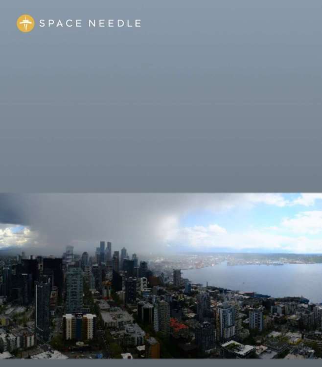
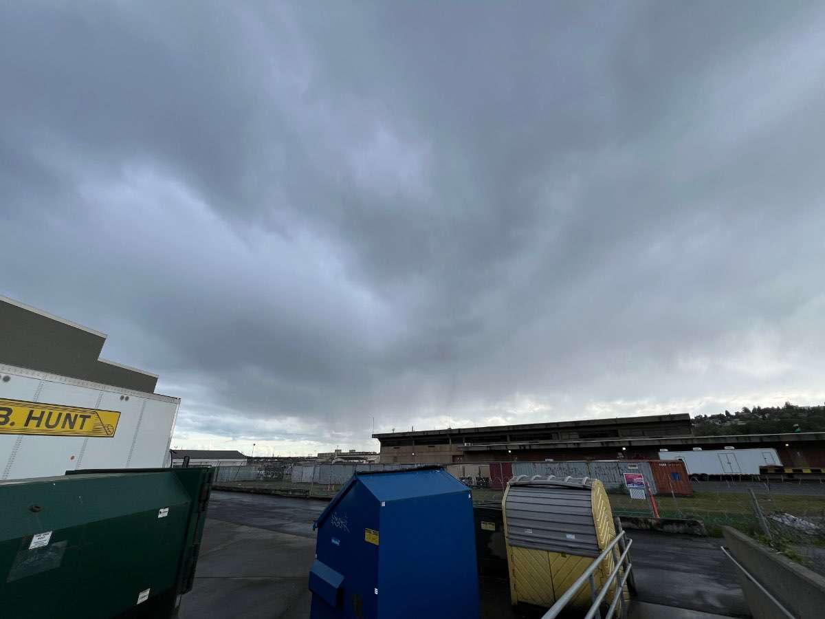
Just got nuked here in Interbay. Some lightning in the area too though I was inside for that.
-
 5
5
-
-
3 minutes ago, TT-SEA said:
A major volcanic eruption usually takes a year to impact the global climate.
I know, there are nuances. It was just a tongue-in-cheek joke
-
1
-
-
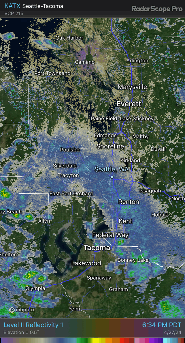
PSCZ starting to fill in from the west. These can be hit or miss especially on a day like today, but here's to hoping for a solid thumping of convective rainfall, maybe even some hail or lightning.
Also I'm relieved to hear reports of mixed rain and snow last night. I was definitely seeing and feeling chunky rain out on my front porch but I kept doubting myself because it's almost fuggin' May. Thought I was going nuts. Pretty cool stuff for our area! And I do feel the need to go on the record to say I called it a few days ago...
")
-
5
-
-
Of course just like any season in any given year, this Summer will play out entirely uniquely, similar to some years but entirely of its own quality. Hopefully the PNW is a donut hole of cool anomalies and a fixed respite from a nearly hemisphere-wide torch. It's the best we can hope for, barring some horrific volcanic eruption.
-
3
-
 1
1
-
-
1 hour ago, T-Town said:
Something is brewing.
Amazing!
-
5
-
-
Heavy rain has quickly cooled things off to the dewpoint here in Lake City. 41/40 spread, with the sound of pouring water outside and radar continuing to fill in further. Feels like Christmas. Keep it comin', baby, keep it green into August!
-
3
-
 1
1
-
 1
1
-
-
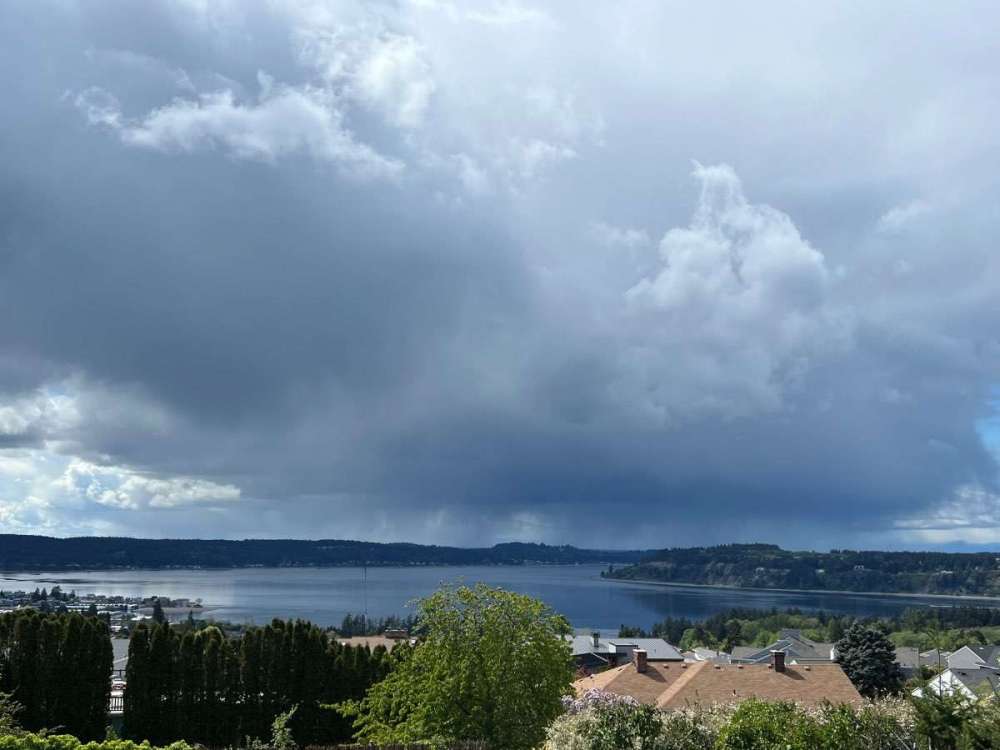
This spinny low thing is pretty well defined. Nice rain event on tap tonight for Everett south. Pretty undermodeled.
-
1
-
2
-
-
That system Wednesday night has hardly wavered across guidance and continues to look like a regional soaker...the second in a week. Pretty surprising considering how poorly put-together of a system it is. Just lots of near-saturated air and a barely defined low.
-
Kind of sucks that next weekend's trough appears to be trending towards sliding into OR/CA entirely. Before it looked like it would at least send a deformation band into the Seattle area, now it appears we will remain under weak ridging.
-
1
-
-

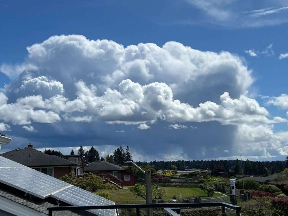
This was a really cool rain band yesterday. No idea what kind of feature this standing wave was.
-
1
-
 1
1
-
 1
1
-
-
3 hours ago, TT-SEA said:
La Nina is rapidly emerging on the SSTA map.

Good god, we are on fire as a planet right now.

-
1
-
1
-
 2
2
-
 1
1
-
 1
1
-
 1
1
-
 1
1
-
 1
1
-
-
18 minutes ago, TT-SEA said:
I was just going to mention that its looks quite nice in Seattle.

Up to 62F here from 59F an hour ago and markedly brighter. Guess I only busted in timing. Clouds held on a few hours longer than I expected; I thought we'd be this clear and warm by lunchtime. Still busting too warm for the models though... They had all areas struggling to reach 60F by 4pm!
-
1
-
-
3 minutes ago, TT-SEA said:
As expected... the 18Z GFS is back to mega troughing.
Yep. And it will probably verify. Even when models inevitably take it away from us a few times again before locking in the troughing around five days in advance. These Spring troughing patterns are potent and highly reliable. It's really too bad you can't enjoy it as much as I do!
-
2
-
1
-
-
12 hours ago, Meatyorologist said:
With today's underperformance, KSEA exactly doubles its April 2024 rainfall total, adding another 0.43" to the bucket and filling it gently to an even 0.86"... Pending some stray stratoform rainbands over the next day.
Tomorrow will clear earlier than modeled over the Sound with a mostly-dissipated occlusion front overhead and weakly negative low level lapse rates. Any residual stratus should be digested mighty well by that steamin' late April sun, mixing skies into hazy sunshine before noon. I'm going for a gutsy 64/47 day at KSEA. Might even get a bit muggy, some CAM's have dewpoints pushing fifty in the favored sheltered areas, despite what I claim to be too much modeled cloudcover.
Bit of a bust on this one. Still mostly cloudy here with lots and lots of stratocumulus, and altostratus plugging the holes in the low level cloud deck. Very little visible blue sky. I thought low level moisture would scour more easily.
KSEA plummeting back down into the mid 50s now with a shower nailing the airport.
-
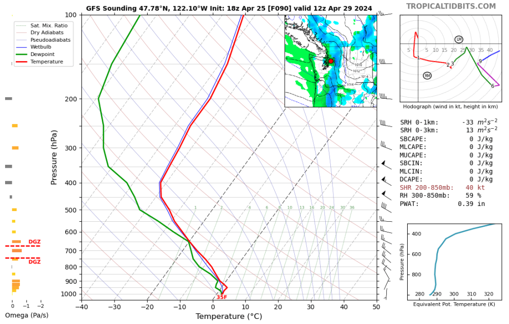
Models have continuously overdelevoped ridges in the 120-240hr range over the last couple months. I doubt tonight's GFS and CMC are starting any new trend.
-
1
-
 1
1
-
-
With today's underperformance, KSEA exactly doubles its April 2024 rainfall total, adding another 0.43" to the bucket and filling it gently to an even 0.86"... Pending some stray stratoform rainbands over the next day.
Tomorrow will clear earlier than modeled over the Sound with a mostly-dissipated occlusion front overhead and weakly negative low level lapse rates. Any residual stratus should be digested mighty well by that steamin' late April sun, mixing skies into hazy sunshine before noon. I'm going for a gutsy 64/47 day at KSEA. Might even get a bit muggy, some CAM's have dewpoints pushing fifty in the favored sheltered areas, despite what I claim to be too much modeled cloudcover.
-
3
-
1
-
1
-
 1
1
-
-
Might score a late season r/s mix Sunday night. That low level airmass is a good one, right from the Bering Sea.
-
3
-
-
2 minutes ago, Sunriver Snow Zone said:
Oh and I also made some Mac and YellowWater, I'm sure @Frontal Snowsquall would be interested!

how do you screw up mac and cheese that badly. mac and cheese. lord.
-
1
-
2
-
1
-
1
-
-
4 minutes ago, SilverFallsAndrew said:
For the record I believe the earth is round.
A disk is round on its edges!
-
1
-
-
Someone else here is having some though!
-
1
-
1
-
3
-
1
-
-
4 hours ago, Cascadia_Wx said:
Any fungi involved?
Not this time! And probably not again for a very long while. Not in any mental state right now to screw around with powerful drugs.
-
1
-
-
4 minutes ago, SilverFallsAndrew said:
I agree. I love to hear the water dripping from the leaves. We aren’t fully leafed out yet, but in a week or two we will be.
Heard a lot of that on my walk last night. That, and I was probably hearing the forest bloom in real time as millions of leaves grew and slowly brushed up against one another on a massive scale, making for little pops along the way. There was no wind, no rain.
-
2
-
-
That system tomorrow is a PNW classic. 24 hours of light-moderate stratoform rain and very little wind for just about everyone from Brookings to the tip of Vancouver Island.
-
6
-
2
-


April 2024 Weather in the PNW
in West of the Rockies
Posted
So close yet so far...