Meatyorologist
-
Posts
8913 -
Joined
-
Last visited
-
Days Won
13
Everything posted by Meatyorologist
-

February 2024 Weather in the PNW
Meatyorologist replied to TigerWoodsLibido's topic in West of the Rockies
Welcome to the 2020s cold Spring regime -
February 2024 Weather in the PNW
Meatyorologist replied to TigerWoodsLibido's topic in West of the Rockies
A true 34F rocking here. Probably lightning too with that setup.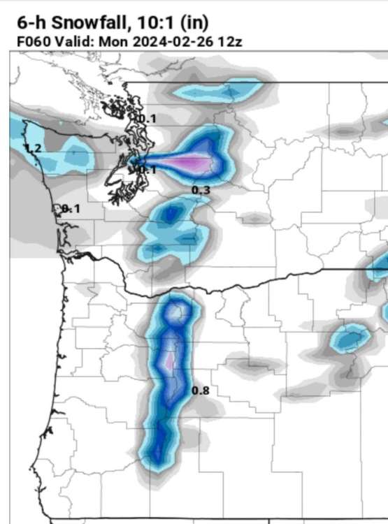
-
February 2024 Weather in the PNW
Meatyorologist replied to TigerWoodsLibido's topic in West of the Rockies
Absolutely crushes me. I think it read my PSCZ post. -
February 2024 Weather in the PNW
Meatyorologist replied to TigerWoodsLibido's topic in West of the Rockies
We have our moments for sure, January 2012 brought us great PSCZ luck. Nov 2010 nailed us unexpectedly and we got core'd on both deformation bands between 2/3 and 2/9 2019. -
February 2024 Weather in the PNW
Meatyorologist replied to TigerWoodsLibido's topic in West of the Rockies
Gooooddddd I love big niche cats. Norwegian Forest Cats are another I'd love to own. Do you have any pictures of her? -
February 2024 Weather in the PNW
Meatyorologist replied to TigerWoodsLibido's topic in West of the Rockies
Bottom one is Feb 2015, correct? Holy hell that is awful to look at. -
February 2024 Weather in the PNW
Meatyorologist replied to TigerWoodsLibido's topic in West of the Rockies
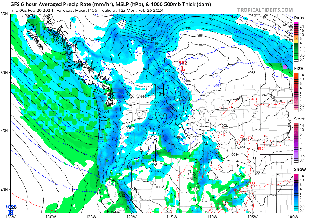
I'm trying to practice Matt's signature stoic equanimity but watching snowmap after snowmap roll out hole'ing me to death with an Olympic mountain range-sized club is starting to get to me... The best lift will be to my immediate north and south, and best thermals 500' up. It's been no coincidence that nearly every scenario has resulted in paltry totals for this little corner of Pseattle. Not that Lake City needs an Achilles Heel, but NW onshore flow is a pretty damning 'snowfall setup' here, if you can call it that. It takes advantage of every wonderful weakness this neighborhood has to offer; Olympic shadowing, low elevation, unfavorable PSCZ placement. Unless we get lucky and luck out on the latter of the three, there's not a whole lot to look forward to until the backend of the trough when overrunning takes over. -
February 2024 Weather in the PNW
Meatyorologist replied to TigerWoodsLibido's topic in West of the Rockies
My brother in Christ, onshore snow is the primary way we get the stuff after mid February. -
February 2024 Weather in the PNW
Meatyorologist replied to TigerWoodsLibido's topic in West of the Rockies
I'm so sorry man. -
February 2024 Weather in the PNW
Meatyorologist replied to TigerWoodsLibido's topic in West of the Rockies
Huh, I guess it has been that bad, hasn't it. The 2010s really hardened me so I haven't really thought of the recent stretch as particularly awful. Guess the increasingly potent cold has helped keep me satisfied anyways. Looking forward to when the next MEATY 974mb heartstopper stalls just SW of Olympia, with a 1062mb Arctic high sitting pretty in west AB, cranking hard into BC in phase with the surface low... -
February 2024 Weather in the PNW
Meatyorologist replied to TigerWoodsLibido's topic in West of the Rockies
Oh no, definitely not. I've always wondered how east wind access and varied topography effect snow prospects in your area. I really have only a college try at a guess, whereas you live there observing it with your own senses. Much like how most people don't understand like I do how the topography here in the Meadowbrook basin stops easterlies from scouring out fog and forms wicked temperature gradients over a small walking distance during warm ridging inversion setups in the late Fall. Or how Snowmizer understands the dynamics of Hood Canal CAD in his backyard during warm overrunning events better than anyone else on the forums. -
February 2024 Weather in the PNW
Meatyorologist replied to TigerWoodsLibido's topic in West of the Rockies
That's classic QPF waffling though. What you were looking at was a weak low/shortwave embedded in a much larger trough, over 100 hours out. That was never more than a transient feature up for scrutiny. It could still realistically come back, too. Or more likely, models will pick up on a new different feature for snowfall. The flipside of the whole deal. Also the GFS still shows spotty light snow Monday night. -
February 2024 Weather in the PNW
Meatyorologist replied to TigerWoodsLibido's topic in West of the Rockies
I'm so confused... That first trough still looks great? With lots of marginal snow chances. Were people on this forum rooting for the models to send that deep Arctic air into the region? And that's why people are mumbling about a "rug pull"? Becuase from my eye, and I've been paying attention for a few days, models haven't really changed at all from yesterday, at least for Washington. Definitely not for Jim. Maybe some waffling in the precip/sfc pressure department but we all know those specifics are a coin flip more than a few days out. Mountains look to get some decent insurance right on time at the end of the season. The second trough in the LR is highly up for debate and could be subject to Niño-fication as it approaches the short range, perhaps trending towards more GOA-spillage and the reintroduction of BSF into our region. But the move towards relatively colder MAMs in recent years makes me believe the big carving out trough solution could be real. -
February 2024 Weather in the PNW
Meatyorologist replied to TigerWoodsLibido's topic in West of the Rockies
What is your point? This is describes every favorable PSCZ snow event ever. You've been saying "this won't last long!" about 500mb troughing, intrusions of Arctic air, and bouts of rainfall. It's like every six hours you forget the concept of impermanence and you relearn via the latest GFS run that all things come and go. -
February 2024 Weather in the PNW
Meatyorologist replied to TigerWoodsLibido's topic in West of the Rockies
What website is this? It looks really fun to sift through -
February 2024 Weather in the PNW
Meatyorologist replied to TigerWoodsLibido's topic in West of the Rockies
It also shows that random CZ from mid January over north Seattle! -
February 2024 Weather in the PNW
Meatyorologist replied to TigerWoodsLibido's topic in West of the Rockies
hmmmmm -
February 2024 Weather in the PNW
Meatyorologist replied to TigerWoodsLibido's topic in West of the Rockies
August 1899 must have been insane. -
February 2024 Weather in the PNW
Meatyorologist replied to TigerWoodsLibido's topic in West of the Rockies
I daydream of what 1993 could have been like. Or 1954... Which is a crazier year because the troughing was equal to or greater in strength and persistence than 1993, yet it was all internally driven; no volcanic influence at all. -
February 2024 Weather in the PNW
Meatyorologist replied to TigerWoodsLibido's topic in West of the Rockies
I remember days during that summer where clouds would take all day to burn off, then in the afternoon, just as the sun finally eroded its own fixture in the sky, you'd see the next marine push ahead of schedule; a wall of clouds spanning miles barreling in from the west. Haven't seen that since. -
February 2024 Weather in the PNW
Meatyorologist replied to TigerWoodsLibido's topic in West of the Rockies
CFS warm bias. Though it'll probably verify more correct than we'd like. -
February 2024 Weather in the PNW
Meatyorologist replied to TigerWoodsLibido's topic in West of the Rockies
My preferences haven't changed, really. I'm just more okay with it getting hot because I can't control the weather. But we can both agree that we've seen far too much of the latter in recent years, and having been born in 2001 I really haven't experienced a truly cold summer. I have sparse memories of persistent clouds in 2010/11 but that's about it. -
February 2024 Weather in the PNW
Meatyorologist replied to TigerWoodsLibido's topic in West of the Rockies
That.... doesn't suck? Plenty of onshore flow in that pattern. -
February 2024 Weather in the PNW
Meatyorologist replied to TigerWoodsLibido's topic in West of the Rockies
I saw a few supplements at the gas station that promised to help. Also... Do we really want to give Jesse or Tim roid rage? Think of the forums man -
February 2024 Weather in the PNW
Meatyorologist replied to TigerWoodsLibido's topic in West of the Rockies
I'm gonna get shadowed hard next week, which is the way it goes with these NW flow type setups. But man is this an impressively dynamic storm. Imagine riding it out on the summit of Mt. Rainier...