OmahaSnowFan
-
Posts
2693 -
Joined
-
Last visited
-
Days Won
1
Everything posted by OmahaSnowFan
-
12Z GFS has upper 60s to low 70s here next Friday. Yes please.
-
February 2020 (It's cold at the end of the run!)
OmahaSnowFan replied to Madtown's topic in East of the Rockies
It’s been crazy to see not just the difference between last February and this one but actually the difference in extremes. Greatest snowfall to 3rd driest. I’m hoping we don’t dry out too much but we have been wet for so long so... -
2/24-2/26 Snow (Ring the doorbell so the big dog wakes up!!!)
OmahaSnowFan replied to Madtown's topic in East of the Rockies
Wowza! URGENT - WINTER WEATHER MESSAGE National Weather Service Buffalo NY 1258 PM EST Wed Feb 26 2020 NYZ006>008-270200- /O.UPG.KBUF.LE.W.0004.200227T1200Z-200229T2300Z/ /O.NEW.KBUF.BZ.W.0001.200227T1200Z-200228T2100Z/ Oswego-Jefferson-Lewis- Including the cities of Oswego, Watertown, and Lowville 1258 PM EST Wed Feb 26 2020 ...BLIZZARD WARNING IN EFFECT FROM 7 AM THURSDAY TO 4 PM EST FRIDAY... * WHAT...Blizzard conditions expected. Total snow accumulations of 3 to 4 feet across the Tug Hill Plateau, and 1 to 2 feet for surrounding lower elevations. Winds gusting as high as 50 to 60 mph will result in severe blowing and drifting snow. * WHERE...The Eastern Lake Ontario Region. * WHEN...From 7 AM Thursday to 4 PM EST Friday. * IMPACTS...Travel could be very difficult to impossible. Areas of blowing snow will produce near zero visibility. The hazardous conditions will impact the morning and evening commutes Thursday and Friday. Strong winds could cause some tree damage and scattered power outages. -
February 2020 (It's cold at the end of the run!)
OmahaSnowFan replied to Madtown's topic in East of the Rockies
Highs this weekend keep getting bumped up with every new forecast package the last couple of days. Now low 60s for both Saturday and Sunday. Hello spring!! -
February 2020 (It's cold at the end of the run!)
OmahaSnowFan replied to Madtown's topic in East of the Rockies
3rd driest February on record so far in Omaha -
February 2020 (It's cold at the end of the run!)
OmahaSnowFan replied to Madtown's topic in East of the Rockies
What a difference a year makes. 27” of snow last year in February. Not even 1” (.8”) this year.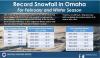
-
2/24-2/26 Snow (Ring the doorbell so the big dog wakes up!!!)
OmahaSnowFan replied to Madtown's topic in East of the Rockies
There’s a narrow warning/ band of snow in central Kansas too. Says 5-10” of snow in that band. Crazy stuff -
February 2020 (It's cold at the end of the run!)
OmahaSnowFan replied to Madtown's topic in East of the Rockies
Thanks! I’ve seen a handful over the years in the part of Omaha I live in. I’m on the northern edge of town. Driving home on Saturday I noticed multiple flocks of geese way up high flying north so you knew they were going somewhere a ways away! -
February 2020 (It's cold at the end of the run!)
OmahaSnowFan replied to Madtown's topic in East of the Rockies
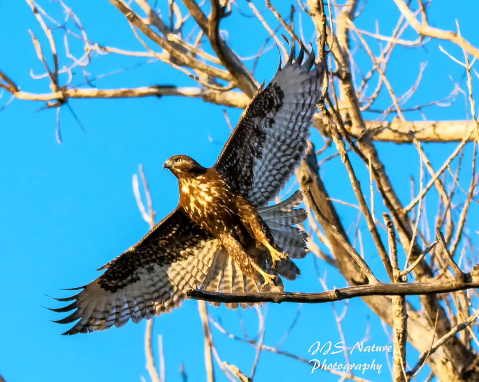
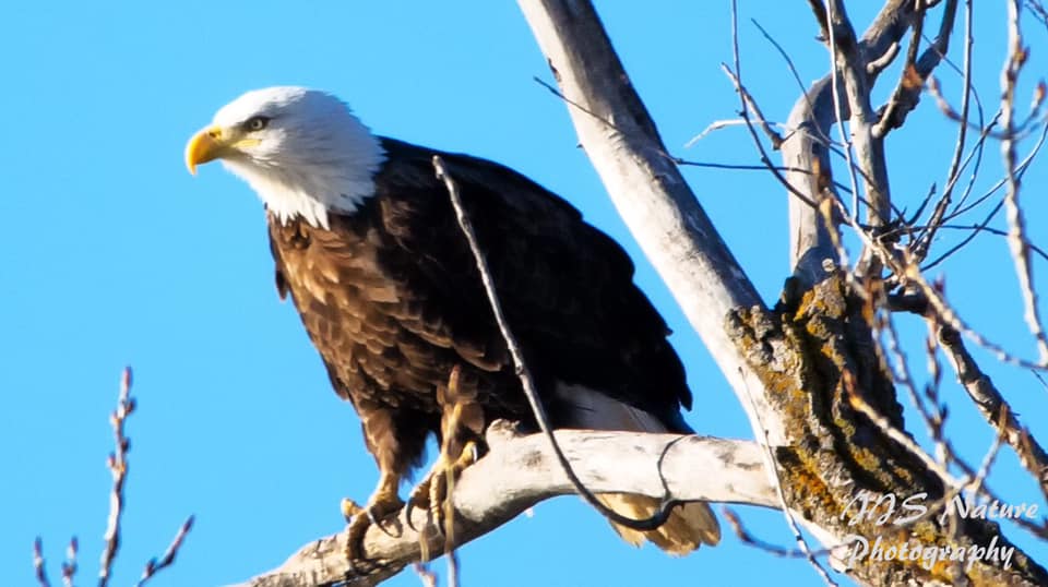
I went out to DeSoto on Saturday this past weekend and caught a couple of good shots. Saw at least 1/2 a dozen of Bald Eagles and several other large hawks. My favorite shot is probably the first one where this hawk was taking off from the tree. I've always loved these "action shots".

- 922 replies
-
- 11
-

-
February 2020 (It's cold at the end of the run!)
OmahaSnowFan replied to Madtown's topic in East of the Rockies
Tulips have popped up in my flower bed on the east side of my house. Also noticed buds on my Magnolia tree in the backyard. -
February 2020 (It's cold at the end of the run!)
OmahaSnowFan replied to Madtown's topic in East of the Rockies
Over performing today. Up to 64 degrees already! -
2/24-2/26 Snow (Ring the doorbell so the big dog wakes up!!!)
OmahaSnowFan replied to Madtown's topic in East of the Rockies
OmaDome for the win on the NAM -
2/24-2/26 Snow (Ring the doorbell so the big dog wakes up!!!)
OmahaSnowFan replied to Madtown's topic in East of the Rockies
Sigh... this storm looks like it could drop more at one time then I’ve had the entire winter -
February 2020 (It's cold at the end of the run!)
OmahaSnowFan replied to Madtown's topic in East of the Rockies
-
February 2020 (It's cold at the end of the run!)
OmahaSnowFan replied to Madtown's topic in East of the Rockies
Man the 0Z run of the GFS definitely looked like early spring! Especially the latter half of the run. Just put a fork in this winter already. -
2/24-2/26 Snow (Ring the doorbell so the big dog wakes up!!!)
OmahaSnowFan replied to Madtown's topic in East of the Rockies
I actually thought that myself. It seems "odd" to put out a graphic for a questionable and marginal setup that is 4 days away yet.... Even if it does snow, it doesn't look like anything too disruptive beyond maybe snowing during rush hour Monday morning -
February 2020 (It's cold at the end of the run!)
OmahaSnowFan replied to Madtown's topic in East of the Rockies
Lies!! All lies!! -
February 2020 (It's cold at the end of the run!)
OmahaSnowFan replied to Madtown's topic in East of the Rockies
So far for the first 19 days of February, I've had .2" of snow and .01" of lt rain. Average temp has been 2.1 degrees above average as well. Zzzzzzzzzzzzzzzzzzzzzzzzzzzzzzzzzzzzzzzzzzzzzzzzzzzzz........................................................................................................... -
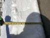
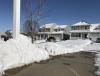
Some pics/images from our big blizzard last year on 2/23. Crazy storm!

-
February 2020 (It's cold at the end of the run!)
OmahaSnowFan replied to Madtown's topic in East of the Rockies
50 yesterday and 56 today. Should be close to 50 tomorrow too depending on cloud cover. -
February 2020 (It's cold at the end of the run!)
OmahaSnowFan replied to Madtown's topic in East of the Rockies
Saw this post on another site. Crazy strong storms in the north Atlantic right now... This is downright the craziest surface analysis I've ever seen; we have:A 933hPa low sitting over the North Atlantic;A new 941hPa core right next to it deepening to 929hPa in 24h;Another system coming in from the SW at 972hPa, forecast at 917hPa (!!) in 24hThree days from now, pretty much the entire North Atlantic at middle latitudes will see waves of 5-15m high and locally even more. Just imagine how much energy is being released onto the ocean surface to do that.You can find the latest analyses here: https://ocean.weather.gov/Atl_tab.php -
I've been lucky enough to see 35-40 tornadoes in my lifetime, but I've been chasing since 2008.
-
February 2020 (It's cold at the end of the run!)
OmahaSnowFan replied to Madtown's topic in East of the Rockies
Made it down to -5.9 on my weather station last night. Coldest low of the season. Looking at the airport obs, the lowest windchill I see from last night was -26. Back up to 9.7 right now with a high in the low teens today, but right back to the 30s tomorrow, 40s Saturday, and then may hit 50 Sunday and Monday. -
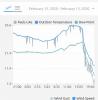
Down to 12.6 here now. We were about 40 just before 4p. Saw the airport had a gust up to 48 mph as well. I’m including the graph of the temperature from my weather station. Wonder when the front came through?!
-
Dropped from 37.2 to 23.2 in the last hour(410-510p) on my weather station. Just some lt flurries here but north winds are gusting up to 45 mph.