Snowy Hibbo
-
Posts
14 -
Joined
-
Last visited
Snowy Hibbo's Achievements
")
Newbie (1/14)
32
Reputation
-
Part II- January 2020 Obs and Discussion
Snowy Hibbo replied to snow_wizard's topic in West of the Rockies
Look like it’s certainly been a wet for the lowlands and snowy for the mountains kind of time in the past few weeks for the PNW. Should continue for about a fortnight IMO. https://longrangesnowcenter.net/2020/01/22/north-america-on-the-long-term-22nd-jan-2/ The latest blog update for North America (the first of 2020, finally) from my perspective. - PNW/BC/Northern Rockies to remain good for the next fortnight, reducing in the second week of Feb. - California/the SW/Southern Rockies to improve for the latter half of February (maybe a bit earlier) - Eastern US expected to improve for the last 15-20 days of February (2nd-3rd weeks of Feb, possibly into the 4th week) IMO. - These impacts may be reduced/weakened by Arctic influence, etc. -
December 2019 Weather Discussion for the PNW
Snowy Hibbo replied to Timmy Supercell's topic in West of the Rockies
https://longrangesnowcenter.net/2019/12/30/north-america-on-the-long-term-30th-december/ Conditions looking good for snowfall over the next two-three weeks for the PNW. The jet is potentially to move further south later in the month, with ridging brought in from the Alaskan domain. -
December 2019 Weather Discussion for the PNW
Snowy Hibbo replied to Timmy Supercell's topic in West of the Rockies
I have been interested in US West Coast weather for quite a while now, just to expand my horizons. -
December 2019 Weather Discussion for the PNW
Snowy Hibbo replied to Timmy Supercell's topic in West of the Rockies
Melbourne, Victoria in the south. -
December 2019 Weather Discussion for the PNW
Snowy Hibbo replied to Timmy Supercell's topic in West of the Rockies
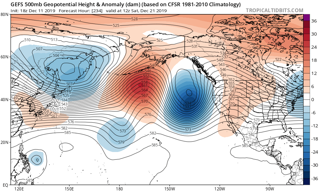
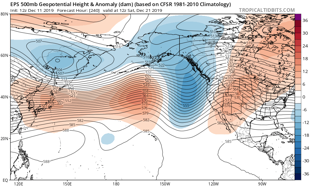
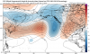
It’s probably more likely to be a bit of both -EPO and +EPO, with the latter slowly fading. It’s just that the +EPO is going to be the outlet as to which the Aleutian Low is displaced upon over the medium term. From something like this: Or it’s opposite here: Both of these particularly the GEFS are very -AAM looks, they have bold anomalies that lie like high to low to high, rather than the Pacific being dominated by a bipole setup with an Aleutian Low. Because there is more momentum down south, the low anomaly that forms the +EPO seems to move on both models down to California in the D10-D15 period, ending the relative +EPO. There will probably be bouts of -EPO forcing, but not strong enough to really force deep cold risk on the Eastern seaboard. So yeah as it’s modelled it probably will favour California beyond the next 10-15 days. And you are right in that there is significant model separation over matters like these. EPS favours a +EPO, while GEFS is more -EPO like. I’d argue that there will be periods of both at least for the medium term. The long term (Late Dec beyond) will probably feature more ridging in the PNW region, because the momentum has been reduced within a GWO Phase 3/4. And the remaining momentum left will probably be more inclined to go south, because of the Aleutian ridging that is to develop.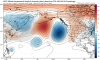
-
December 2019 Weather Discussion for the PNW
Snowy Hibbo replied to Timmy Supercell's topic in West of the Rockies
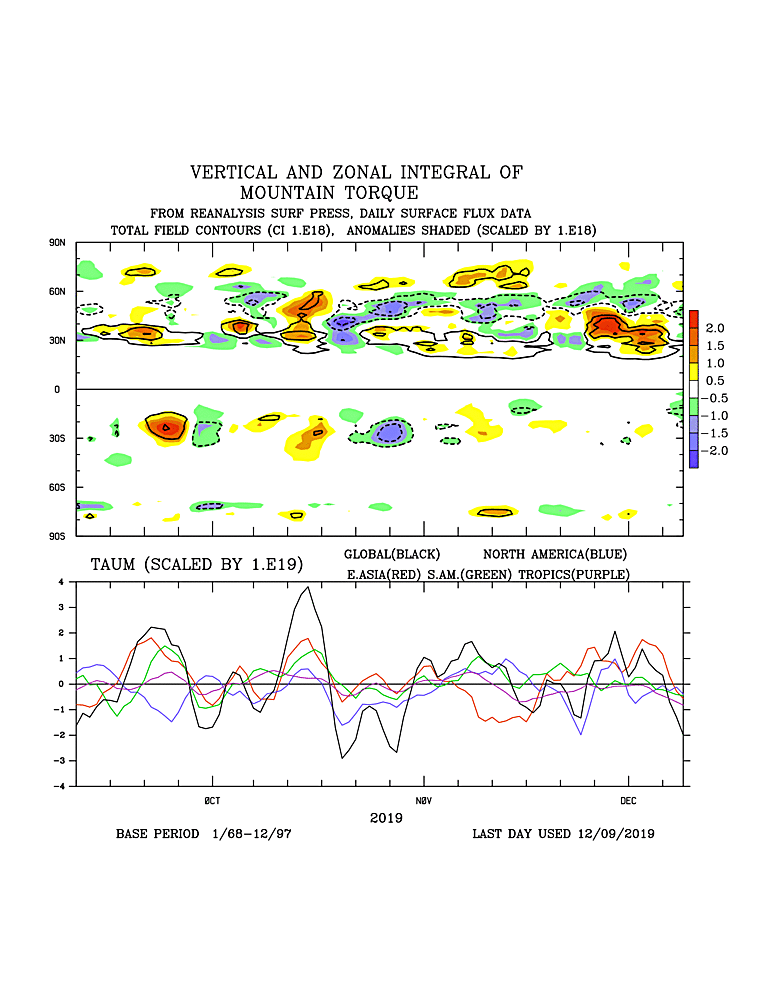
Here’s a fresh chart for you: EAMT declining, and MT worldwide well into the negatives. Will see GWO Phase 2 very soon. And we probably won’t see a positive MT for a while.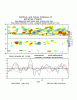
-
December 2019 Weather Discussion for the PNW
Snowy Hibbo replied to Timmy Supercell's topic in West of the Rockies
Yeah I concur with that. That’s what I meant, sorry if I was rambling on. The gradual scrubbing of the momentum anomalies over the next 10-15 days will dislodge the Aleutian Low as it previously standed, and allow the development of a strong +EPO, with -AAM-esque anomalies driving it. Today (per NP jetstream analysis) is the peak of the effects of the +EAMT. -
December 2019 Weather Discussion for the PNW
Snowy Hibbo replied to Timmy Supercell's topic in West of the Rockies
I reckon he’s better than me personally. And as for local, well I’m actually from Australia, so not so local -
December 2019 Weather Discussion for the PNW
Snowy Hibbo replied to Timmy Supercell's topic in West of the Rockies
Thanks. No not necessarily, equating these weather patterns to each other in this case is specific, rather than as a general rule. On many occasions, a +EAMT supports rather the opposite, a +PNA. But in this case, the extension of the jet results from an increase in momentum in the North Pacific basin IMO. The FT has been negative for sometime, though there are some positive FT anomalies in the NH subtropics. But I do agree with the overall view you have here, you are going to need the atmospheric base state to change from the IO to WPAC. I’d however argue that won’t happen anytime soon, probably more likely (gradually of course) to be seen in January. For now, the West Coast should benefit until the momentum anomalies are scrubbed from the NP basin, at which point it is up to the synoptics in this scenario. Of course there’s a fair amount of talk at the moment about -NAM and -NAOs, which doesn’t affect the PNW directly, but will have eventual downstream effects. -
December 2019 Weather Discussion for the PNW
Snowy Hibbo replied to Timmy Supercell's topic in West of the Rockies
I have tried multiple times over the past few months and failed, and it finally worked this time. Apparently persistence is key -
December 2019 Weather Discussion for the PNW
Snowy Hibbo replied to Timmy Supercell's topic in West of the Rockies
No educational background in the subject, just been around for a while doing as a hobby and interested in medium-long range weather patterns primarily. Run a blog and am on several other forums. -
December 2019 Weather Discussion for the PNW
Snowy Hibbo replied to Timmy Supercell's topic in West of the Rockies
We are certainly starting to see the modelling reflect a more -PNA like look in the LR per this EPS run: This means things will get interesting for the PNW and the whole West Coast region for the majority of December, as per the details of the drivers in my long term outlook here This is caused by the concluding +EAMT and a synoptic situation and base state that supports such PNA domain changes and hence snowfall for the PNW.