uticasnow
-
Posts
97 -
Joined
-
Last visited
Everything posted by uticasnow
-
Grand Rapids getting serious: -- Increased chances for impactful mid-week winter storm -- Confidence is growing that there will be a winter storm either directly impacting or in the vicinity of Lower Michigan. In fact, ensemble guidance has begun to converge on a solution that, should it occur, would be reminiscent of our recent December 22, 2022 blizzard. This would mean widespread snow accumulations well over 6 inches, followed by lake effect snow along with very strong northwest winds that could produce blizzard-like conditions Wednesday morning. However, precipitation type is far from certain; a significant rain component remains possible and this could significantly curtail snow accumulations. While what`s described above is far from certain at this point, I still feel it is worth mentioning now as a possibility for the following reasons: 1) It is not too early to be thinking about contingency plans for possible travel and power disruptions next week. 2) There has been a signal for a major pattern shift starting nearly a week ago. This has consistently featured a deep, strongly phased western U.S. trough resulting in surface cyclogenesis in the lee of southern Rockies. These have a strong climatological propensity to track northeast towards the Ohio Valley, often while deepening. 3) Past storms in recent memory exhibiting this pattern showed remarkable predictability and consistency in model guidance leading right up to the event. This presumably has much to do with inherent predictability associated with deep longwave troughs such as the one we`re dealing with now. 4) Ensemble solutions, particularly the ECWMF Ensemble (ECE), indicate potential for explosive cyclogenesis as the surface low tracks toward the Ohio Valley. The ECE mean MSLP has dropped to 980 mb, which would imply that several ensemble member solutions feature minimum pressures significantly less than that. Not surprisingly, we are now seeing Shift of Tails (SoT) values in the ECE approaching 2 or greater over parts of Lower Michigan. This means that there are several ensemble member solutions behaving as extreme outliers relative to ECE model climatology. This also emphasizes strong positional sensitivity to the forecast when dealing with what could be a very deep surface low setting up somewhere. While it`s easy to focus on what snow occurs (which undoubtedly could be especially jarring given the winter that we`ve had so far), we are just as concerned about the wind threat that may manifest on the back side of the exiting, deepening low. The official forecast will continue to smear wind speeds downward due to averaging of model solutions, but it should be noted that we could in fact experience very significant northwest winds and gusts that may impact much of Lower Michigan sometime in the middle of the coming week.
-
So true......
-
January 2024 Observations and Discussion
uticasnow replied to Minny_Weather's topic in East of the Rockies
Thanks! -
January 2024 Observations and Discussion
uticasnow replied to Minny_Weather's topic in East of the Rockies
Sorry for my ignorance, but is the one on the right the most current? -
January 2024 Observations and Discussion
uticasnow replied to Minny_Weather's topic in East of the Rockies
Boy this thread really died out quick... -
January 2024 Observations and Discussion
uticasnow replied to Minny_Weather's topic in East of the Rockies
Detroit doesn't seem too hyped about the end of next week: Cold air trailing this system brings a brief shot of below normal temperatures for highs limited to the 20s Thursday which quickly swing warmer by Friday. -
January 2024 Observations and Discussion
uticasnow replied to Minny_Weather's topic in East of the Rockies
Storm threads for upcoming storms? -
January 2024 Observations and Discussion
uticasnow replied to Minny_Weather's topic in East of the Rockies
When posting maps can everybody post Maps of the entire Midwest area including the Great Lakes (Michigan, etc) It would be much appreciated Thanks! -
I would say at least half of what fell melted yesterday and today
-
Alot of the snow is melting away today....
-
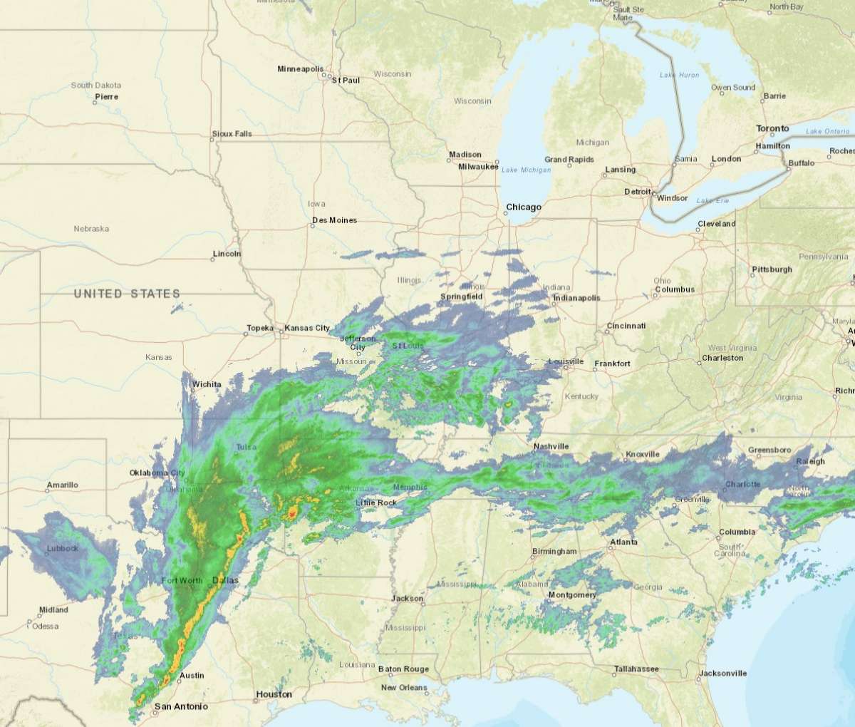
Do I see two separate Low pressure centers?
-
March 1st-4th...Major Winterstorm Potential
uticasnow replied to Niko's topic in East of the Rockies
-
March 1st-4th...Major Winterstorm Potential
uticasnow replied to Niko's topic in East of the Rockies
Good luck...hope your power goes back on soon -
March 1st-4th...Major Winterstorm Potential
uticasnow replied to Niko's topic in East of the Rockies
Finally a true snow storm here in southeast Michigan! -
March 1st-4th...Major Winterstorm Potential
uticasnow replied to Niko's topic in East of the Rockies
Now it's snowing 3:35PM Macomb County southeast Michigan -
March 1st-4th...Major Winterstorm Potential
uticasnow replied to Niko's topic in East of the Rockies
Nothing here in Macomb County yet! -
March 1st-4th...Major Winterstorm Potential
uticasnow replied to Niko's topic in East of the Rockies
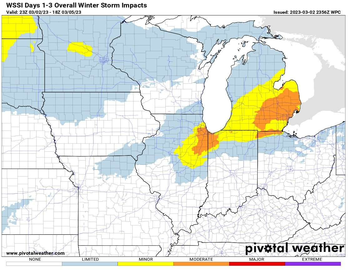
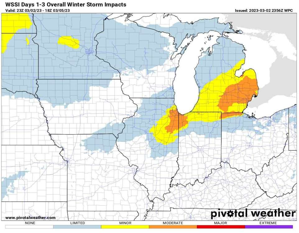
WPC Winter Storm Impacts Days 1-3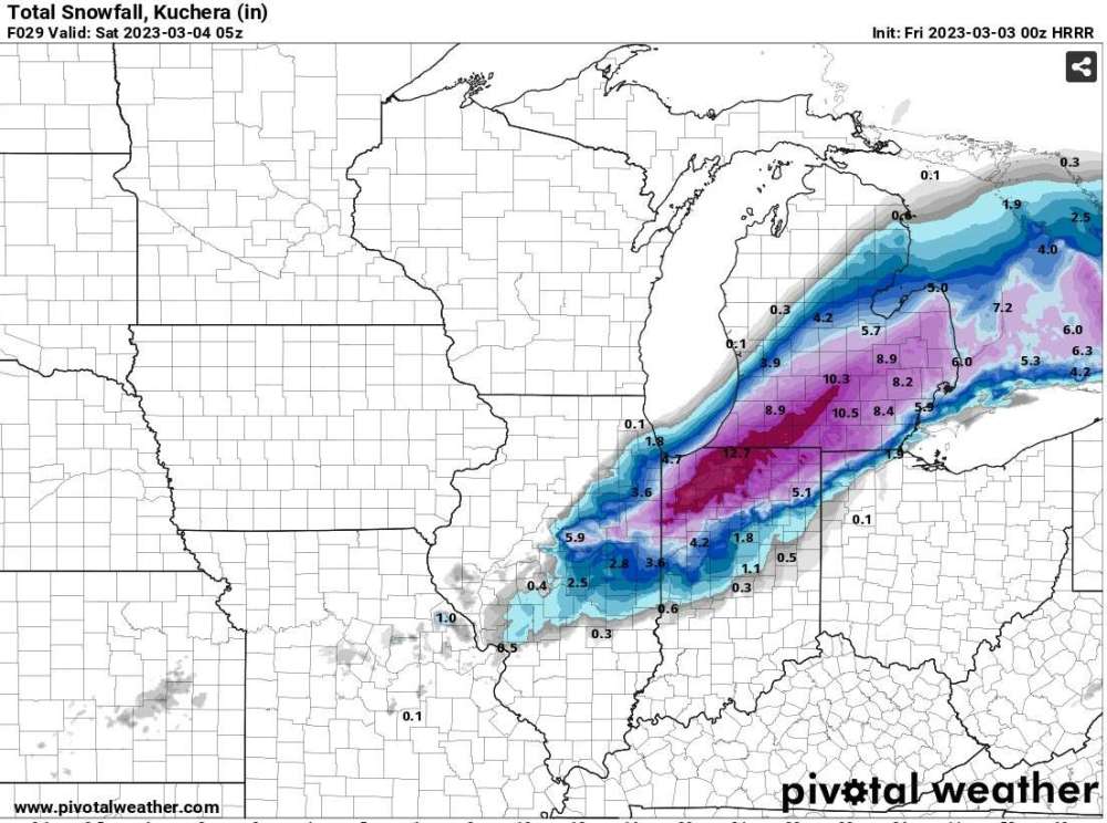
-
March 1st-4th...Major Winterstorm Potential
uticasnow replied to Niko's topic in East of the Rockies
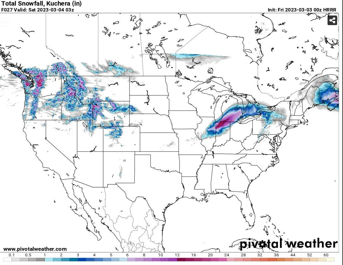
HRRR Total Snowfall Ending Saturday Regional view -
March 1st-4th...Major Winterstorm Potential
uticasnow replied to Niko's topic in East of the Rockies
HRRR Snow total Saturday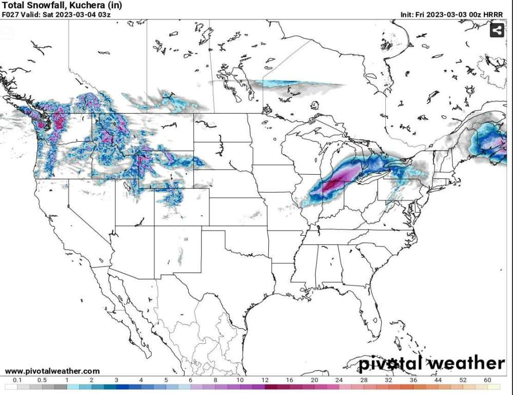
-
March 1st-4th...Major Winterstorm Potential
uticasnow replied to Niko's topic in East of the Rockies
And so it begins.....
-
March 1st-4th...Major Winterstorm Potential
uticasnow replied to Niko's topic in East of the Rockies
ECMF 6AM SATURDAY
-
March 1st-4th...Major Winterstorm Potential
uticasnow replied to Niko's topic in East of the Rockies
NWS DETROIT SNOWFALL PREDICTION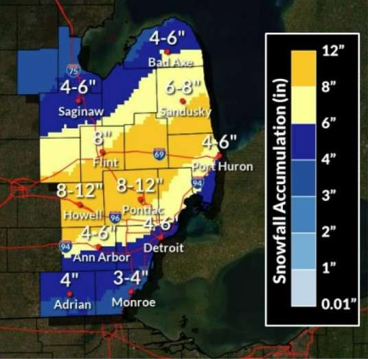
-
March 1st-4th...Major Winterstorm Potential
uticasnow replied to Niko's topic in East of the Rockies
-
March 1st-4th...Major Winterstorm Potential
uticasnow replied to Niko's topic in East of the Rockies
Looking more likely for snowstorm for southeast Michigan...... latest DTX discussion Winter Storm Watch for heavy wet snow accumulation potential remains in effect for all of southeast Michigan for Friday afternoon through much of Friday night. Moderate to heavy wet accumulating snow will be possible during this timeframe, along with wind gusts of 35-45 mph. Potential for freezing rain and subsequent minor ice accumulations continues to decrease. Rain will also be possible, with highest confidence in a transition to rain across southern portions of the region. Peak of the event will be in the 4pm-10pm timeframe, with significant travel disruptions to the Friday evening commute likely. Snowfall rates of 1-2+ inches per hour will be possible where the heaviest snowfall occurs. Where the heaviest snowfall occurs, the potential exists for 6-10 inches of accumulation, with localized 12+ inch totals. However, there remains significant model spread in potential snow amounts across much of southeast Michigan. More specifics on snow probabilities are discussed below. Unusually high forecast uncertainty remains regarding where exactly the rain/snow line sets up and the placement of highest snowfall totals. Precipitation types will be crucial in determining locations and higher end snowfall amounts. More specifics on model variability with respect to the upcoming winter storm are discussed below. -
March 1st-4th...Major Winterstorm Potential
uticasnow replied to Niko's topic in East of the Rockies
I know, not getting hopes up but this one might be different