Scott
-
Posts
646 -
Joined
-
Last visited
-
Days Won
1
Everything posted by Scott
-
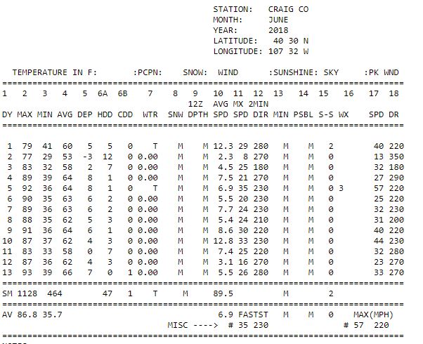
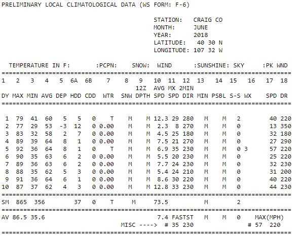
The 100 almost surely isn't valid. The 100 was supposedly recorded on 6/12/1936. None of the other weather stations in the area, including the ones which are normally warmer than Craig had highs close to that; the warmest being at Sunbeam 7 SW (which is usually a warmer location than Craig) with a 91. Further in all other locations, the 12th was not close to the warmest day of the month. 6/19/1936 through 6/21/936 was a lot warmer at all other locations. The 100 is almost certainly an error. The 65 on 7/31/1966 may be valid; I don't know. There was also a reported 66 on 7/2/1963 and a 64 on 6/29/1970. At the airport the warmest readings were 63 on 8/2/2007 and now on 7/9/2018. Interestingly, the 1894-1976 station never had a August night warmer than 61. Nights above 60 are very rare at both weather stations and in most years don't occur. 1976-present, as soon as the old COOP station ended. The station was moved to the airport, which now has 42 years of data. There is also a station at Craig 4SW, which started at same time (1976 to present) but that one is not a good one to use. It is full of inaccurate and missing data, and especially in recent years the data collectors have gotten really lazy (I used to work at the place collecting the data). Further, the station sits on a hill and the temperatures are often very different than in town. Craig 4SW tends to be warmer in the mornings, cooler in the afternoons (except in winter), and windier than in town. It is also a snowier location than in town, though the weather records don't show this because there is so much erroneous and missing data. They also put the snow depth measurement location on a south facing hill. I wouldn't trust the Craig 4SW station. The other two stations (Craig-Moffat [Airport] and the COOP from 1894-1976) are much more trustworthy.
-
Craig Airport had it's warmest reading in history on 7/8/2018 with 99 degrees. The previous record was 98. On 7/9/2018, the low was 63 degrees. This was the warmest low ever recorded in July and ties the record warmest night. And no, there is no UHI here.
-
It does get cool here at night, even in summer, but I'm guessing the forecast is a little off.

-
DIA is prone to more extremes on both ends of the temperature spectrum, including cold records as well. There were warmer places: Las Animas: 110 Lamar: 109 La Junta: 108 Pueblo: 106 Some news reports were saying that Cheyenne hit 101 (all time record 100), but 99 is what I see? Near were I live, Craig Airport tied it's all time record of 98.
-
Las Animas and Lamar were forecasted to be 111, so that would put it in the range of one of the hottest days in Colorado. It didn't make it though. It was at 107 and quickly cooled to 101. Cloud cover or wind maybe? DIA hit 105, tying the all time record for Denver.
-
As of 8 PM tonight, NOAA just bumped the forecast up and are now forecasting temperatures hotter than that. DIA is supposed to be 104: https://forecast.weather.gov/MapClick.php?lat=39.74001000000004&lon=-104.99201999999997#.WzRKutVKjIU Tomorrow is supposed to be one of the hottest days in Colorado history.
-
32 this morning at the house when I left for work. It has been such a hot June that I think that this might be our last frost of the season. I'm guessing we won't see another frost until late August/early September.
-
Officially the low this morning was 50 at the Craig Airport due to cloud cover and high winds. This is by far the warmest low of the year and the warmest night since last August.
-
Still hot and dry with no measurable precipitation this month. Yesterday was 93, the hottest day of the year so far. At least the nights are still in the 30's.
-
If we don't start getting some moisture soon, much of West is going to burn to the ground, especially much of California, Arizona, New Mexico, Colorado, and Utah.
-
The trend continues; lows near freezing and highs near 90, though it's supposed to be cooler today. Also, 29 at my house this morning.
-
Hot days here (especially considering an elevation of 6200 feet) with nights near freezing and dry, dry, dry seems to be the theme here: It's still green here, but drying out quickly, especially with the hot and dry weather.
-
For official weather stations at least, Lamar had us beat by one degree (for diurnal change). 47 to 104.
-
The official high was 92 today. The 39 to 89 yesterday doesn't look so impressive now compared to today's 32 to 92 (36 to 92 at the airport).
-
(Updated) It happen today. It was 32 this morning at home and the 12:30 and 12:35 PM official temperatures were 90F: https://forecast.weather.gov/MapClick.php?lat=40.518014900000026&lon=-107.54947359999994#.WxbadO4vzIU If it stays clear, it could rise a few degrees more in the afternoon.
-
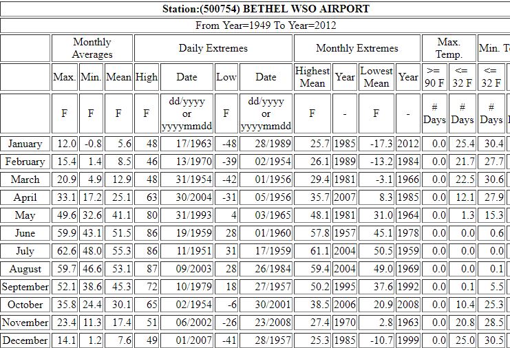
Compared to the Eastern US, or the West Coast, yes, but not really for much of the interior West. All of the Western states have locations where 50 degree diurnal changes are very common. Most of them aren't major cities, but Reno is an exception. There are literally hundreds of stations out west where 50 degree diurnal changes are very common. More than 60 degrees is less common, but 50 degrees isn't unusual at all. All Western states have such locations. Oregon has Seneca, Idaho has Stanley, California has Bodie, Nevada has Elko, Utah has Ibapah, New Mexico has Galivan, Colorado has Alamosa, Wyoming has Basin, etc., etc. Even at the airport here (nights are cooler at my house than at the airport), the average July high is 88 and the average low 46. Cloudy days and nights have less diurnal changes (30 degrees), but clear days are often in the 50-60 degree range, so the average balances out to 42 degrees on an "average" day. Since nights are cooler at the house, the average range is about 48 degrees. There are several other places out West that have similar diurnal changes. 50 degrees isn't a massive diurnal change for an interior location in the Interior West. It may be "massive" for the West Coast or most areas east of the Rockies, but not in the Interior West.
-
Denver has smaller diurnal changes than much of Colorado. Freezing to 90's isn't that uncommon where I live. Places like Alamosa and Gunnison can have some big diunral changes as well. Anywhere in an exposed valley floor in Colorado is going to have larger diurnal changes than Denver. Anyway, we haven't had any big diurnal changes this month yet, but June is a good month for them. Thus far this month though, all days have had dirunal changes only between 38-51 degrees, but the month is just beginning and I'd expect at least some of them to be close to the 60 degree range by month's end. Update: Today's range at the official station was 39 to 89, so still no big diurnal days yet this month.
-
I'd say both are questionable, but not entirely impossible. Both seem overexposed in relation to other readings in Montana during those two heat waves. Personally, I believe that these 113's are all plausible: Hysham 25 SSE on 7/15/2002 Garland on 7/17/1923 Miles City on 7/16/1966 Culbertson on 7/5/1937 Glasgow on 7/31/1900 The 115 at Outlook on 7/5/1937 seems a little overexposed compared to the surrounding areas. Same with the 114 at Radersburg on 7/13/1896. It is also interesting that there have been no readings below 11 in Montana in June. Hegben Dam as well.
-
I'd say overexposed. Between 1976 and 1979 Haines was at or near the top of the list when it came to warm temperatures in Alaska in the summer months. From 1980 onward, it drops way down the list and doesn't have anywhere close to the warmest readings in Alaska for any summer month. There was definitely something going on with the weather station during that time period.
-
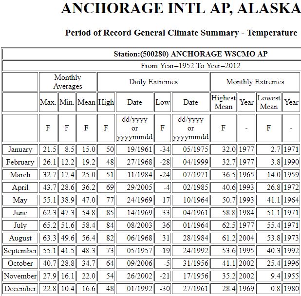
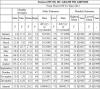
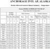
Which ones are you referring to? These ones? None of the 100's measured at old COOP's in Alaska are reliable, it isn't even a question in my opinion. We have: 104 on 6/7/1936 @ Ruby 102 on 6/26/1916 @ Camp #6 100 on 6/20/1915 @ Anchorage 100 on 6/27/1915 @ Fort Yukon 100 on 7/30/1907 @ Teikhill No, I don't think they are due to a shift in climate. The 100 in Anchorage, for example just isn't plausible climate shift or not.
-
I don't know, but it is strange. In places like Barrow, it can be expected that January would often get warmer than February, but even then why December? Barrow Airport has risen above freezing (33 or above) 5 years in January, 2 years in February, 2 years in March, and 1 year in December. The only area that I can think of a good explanation is the Yukon River Valley (including Fairbanks). While January averages the coldest month, most or all of the warm spells come from Chinooks off the Alaska Range. All winter months are probably equally prone to Chinooks. Still, it is interesting that January is the only month between November and February that it has risen above 50 in more than one year. True, but why?
-
This brings up a curiosity that I have had. It is actually common for locations in Alaska to have higher records in January than in February, March, November, and December. While this may be expected in places like St Paul Island, Barrow, or Prudhoe Bay, it is common all over Alaska. I haven't gone through all the WRCC basis, but before the internet existed, I hand copied all the station records I could find for Alaska using sources at the library. I had a total of 51 stations. Here are the months that had the lowest monthly record high for the stations: January = 8 lowest monthly record highs February = 10 lowest monthly record highs March = 5 lowest monthly record highs November = 3 lowest monthly record highs December = 25 lowest monthly record highs I don't know why it is so common for January to have higher record highs than February, March, November, and December, but it is. You would think that it might be one or two state wide warm spells tipping the balance, but it isn't. This is true in all parts of Alaska. Here are random examples from most regions of the state: These aren't isolated anomalies either and it seems to be at least as common as not.
-
The station looks like it was in the same location since 1973 at least, so I would guess that it would be the equipment.
-
I wonder what the high in August would be if the Tanakee Springs reading is dismissed. This is more complicated than it should be. I did find the highest reading recorded in Alaska though. Eielson Visitor Center high 140 in 8/2005, making this the highest reading on earth! It should be the true state record. Anyway, Matanuska Valley 16 supposedly record a 98 on 8/6/1966, but this seems very dubious. The next highest Alaska reading was 85. McKinley River (RAWS) had a 98 in 8/1995, but this one is not valid. No other readings in Alaska were above 83 that month. Haines supposedly had a 95 on 8/1/1978, but looking through the data, I really believe that the Haines station may have had over-exposed readings between 1976 and 1978. Haines had several readings in the low to mid 90's in August those years and then none since then. Though they did happen during known warm spells, they don't seem that well collaborated with other stations. I wouldn't rule them out completely, but I'm guessing that the readings were probably over exposed by at least a few degrees. Other places in interior Alaska did get almost or as warm though, so there is is a possibility that they might be valid. Mankomen Lake supposedly record a 94 on 8/12/2005, but the record high in July is only 84. There were a lot of high readings in 8/1995 though, so maybe some are valid. It seems like this one might be valid. Some high readings (Some were mentioned earlier): Upper Tsaina River Snotel = 99 Thorne Bay RAWS = 95 Maybe some are valid? Which ones though? It's hard to say, especially with RAWS and Snotels. At least three locations have recorded temperature of 93 in August: College Observatory on 8/6/1994 Eagle on 8/6/1977 Tok on 8/6/1994 These are almost certainly valid.
-
Yes, I'll think I'll just admit that Portland really did hit -39 in 2/1943.