Grizzcoat
-
Posts
4887 -
Joined
-
Last visited
-
Days Won
16
Everything posted by Grizzcoat
-

January 11-13 Major Winter Storm/Blizzard
Grizzcoat replied to Hoosier's topic in East of the Rockies
NW IA -- BLIZZARD WARNING-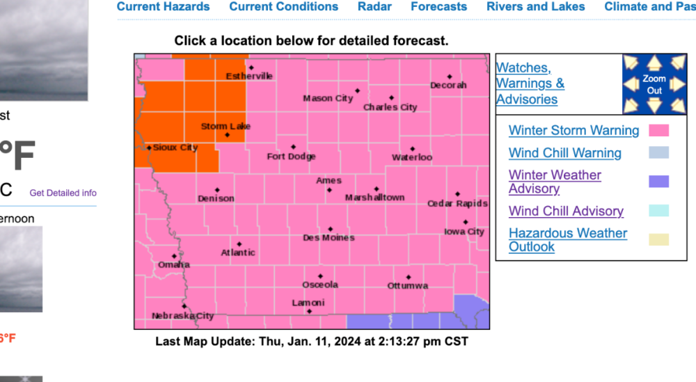
-
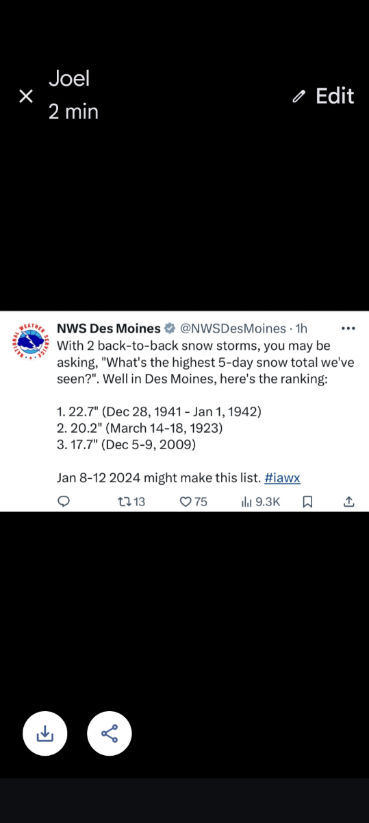
January 2024 Observations and Discussion
Grizzcoat replied to Minny_Weather's topic in East of the Rockies
Back up and transmitting ob's!!! 24 hours nap job -- whatever it is , doesn't look good for LAWRS / ATC doing weather rather than a trained professional that's only job IS weather. Data at: 2037 UTC 11 Jan 2024 KLNK 111954Z 03016KT 10SM BKN100 M11/M16 A2983 RMK AO2 SLP120 T11111161 KLNK 111854Z 03017KT 10SM SCT110 M11/M16 A2986 RMK AO2 SLP130 T11111161 KLNK 101854Z 23007KT 10SM CLR M02/M07 A2939 RMK AO2 SLP967 T10171067 KLNK 101754Z 21009KT 10SM CLR M03/M08 A2942 RMK AO2 SLP977 T10281078 11028 21106 58013 -
January 11-13 Major Winter Storm/Blizzard
Grizzcoat replied to Hoosier's topic in East of the Rockies
I was just going to write something on this. Most models are imo- too fine scaled down to grids that are impossible to define. Especially your Cam's / 3km NAM etc. I mean - come on what exactly are we trying to do here? I like the ICON. It did very well with last system and the scale/grid is about as much as you can expect ( as with other globals) Trying to define something as nearly infinitely complex as the atmosphere in chaos down to 2-5 miles is nuts. I don't care how good the physics are. -
January 11-13 Major Winter Storm/Blizzard
Grizzcoat replied to Hoosier's topic in East of the Rockies
Also gotta remember even though it's basically a nowcast- dealing with the 18z NAM. -
January 11-13 Major Winter Storm/Blizzard
Grizzcoat replied to Hoosier's topic in East of the Rockies
Like I mentioned earlier- the trowal feature on this system is going to be hard to figure out-- likely last minute. -
January 11-13 Major Winter Storm/Blizzard
Grizzcoat replied to Hoosier's topic in East of the Rockies
It is S.IA -
January 11-13 Major Winter Storm/Blizzard
Grizzcoat replied to Hoosier's topic in East of the Rockies
Nam coming in HOT- ( juiced) - appears S *** edit maybe not juiced, but S. -
January 11-13 Major Winter Storm/Blizzard
Grizzcoat replied to Hoosier's topic in East of the Rockies
Euro gives me 1'. I don't trust it with it's bad initializing with surface temps. Wish I had access to upper air soundings and see if they match the 850/ 925 mb temps at 18Z -- I doubt it, can't totally discount past 12-18 hrs , but as Gosaints said, it's likely struggling with the WAA snows -
January 11-13 Major Winter Storm/Blizzard
Grizzcoat replied to Hoosier's topic in East of the Rockies
Euro is 10-15F off at 6 hours-- horrible. Might show a NW trend the Euro is not seeing. Just looking at things with reason. -
January 11-13 Major Winter Storm/Blizzard
Grizzcoat replied to Hoosier's topic in East of the Rockies
Euro at 6hrs for noon today temps vs actual temps -- never seen it that bad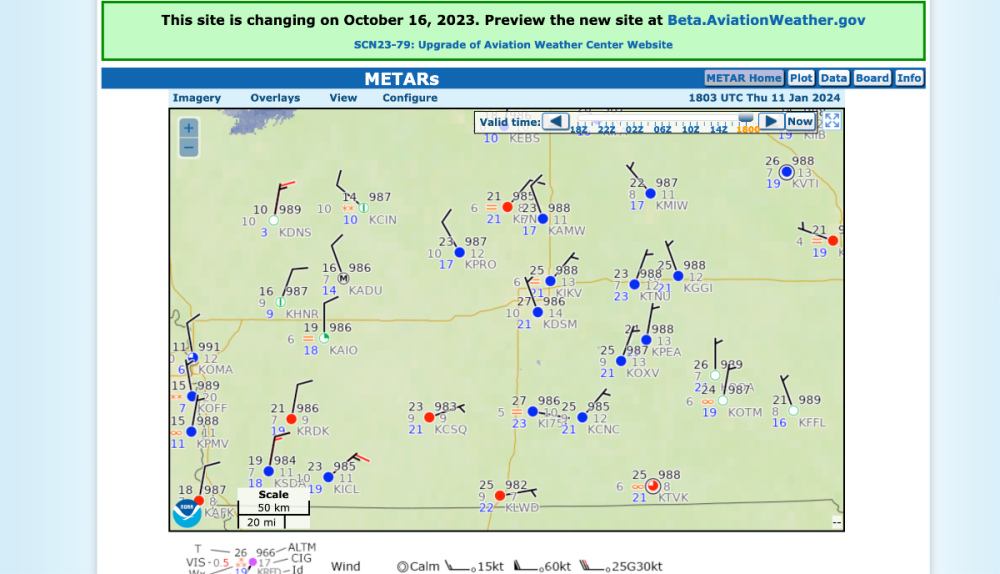
-
January 11-13 Major Winter Storm/Blizzard
Grizzcoat replied to Hoosier's topic in East of the Rockies
The Euro is not initializing well with temps in C.IA-- way off. -
January 11-13 Major Winter Storm/Blizzard
Grizzcoat replied to Hoosier's topic in East of the Rockies
At 12.4"
-
January 11-13 Major Winter Storm/Blizzard
Grizzcoat replied to Hoosier's topic in East of the Rockies
...Central Plains, Great Lakes and interior Northeast... Days 1-3... A digging trough crossing AZ today will take on a negative tilt after crossing the southern Rockies this evening as a double-barreled jet becomes more buckled and S-shaped across the Great Lakes into Friday. This will drive strong upper level divergence and rapid surface cyclogenesis with a deepening area of low pressure lifting Friday from the Ozarks through the Midwest and over the L.P. of MI Friday night. This is a strikingly similar track to the exiting system though it forms farther east over the Plains). Snow will rapidly increase in coverage and intensity north of the low this evening over the central Plains and then IA through MI late tonight through Friday evening. As the low tracks away on Saturday, intense lake-effect snow develops, covering all five Great Lakes by Saturday night. Initial WAA over colder sfc air tonight will likely support a wintry mix in the rain to snow transition zone from northeast KS into northern IL. North in the snow zone, significant snowfall is expected on the northwest side of the low as a deformation band forms and slowly pivots across the area, coincident with an intense TROWAL as the WCB wraps into the low. High-end potential is >18" per PWPF from peak development and lake enhancement in southeast WI and northeast portions of the L.P., driven by strong UVV into a sufficiently deep DGZ. Day 1.5 snow probs for >8" are 20-50% from eastern Neb through central IA, increasing on the Day 2 to 40-90% from the WI/IL border across the L.P. The powerful cyclone reaches peak intensity over the L.P. Friday night with MSLP in the low 970s making for very strong winds and a blizzard threat north and west of the low through this time. Strong northwest to west flow on the back side of the low envelopes the Great Lakes in the wake with LES beginning off Lake Superior Saturday and the rest of the Great Lakes by late Saturday night and continuing in earnest through at least Sunday night. Day 3 snow probs for >6" are 40-80% for typical NW and W snow belts. -
January 2024 Observations and Discussion
Grizzcoat replied to Minny_Weather's topic in East of the Rockies
12Z GFS says Nanook of The North returns a little over a week from now. -
January 11-13 Major Winter Storm/Blizzard
Grizzcoat replied to Hoosier's topic in East of the Rockies
GEM has been very consistent with heavy stripe from E.NE into C.IA --- very consistent -
January 11-13 Major Winter Storm/Blizzard
Grizzcoat replied to Hoosier's topic in East of the Rockies
GFS and NAM world's apart in SE IA- -
January 2024 Observations and Discussion
Grizzcoat replied to Minny_Weather's topic in East of the Rockies
Anybody know what's going at KLNK (Lincoln,NE) -- no weather observations transmitted in the last 20 hours. Supposed to be done LAWRS (ATC)-- apparently not backing up ASOS. NO weather (NIL) being reported makes it illegal per FAA regs for commercial aircraft to land or take off. Not a good situation especially with a Winter Storm approaching. Last report was yesterday 12:54 pm Data at: 1532 UTC 11 Jan 2024 KLNK 101854Z 23007KT 10SM CLR M02/M07 A2939 RMK AO2 SLP967 T10171067 -
January 11-13 Major Winter Storm/Blizzard
Grizzcoat replied to Hoosier's topic in East of the Rockies
I don't think any model right now is doing good at handling the trowal- that could/should be some intense stuff. WPC thoughts- Initial WAA over colder sfc air tonight will likely support a wintry mix in the rain to snow transition zone from northeast KS into northern IL. North in the snow zone, significant snowfall is expected on the northwest side of the low as a deformation band forms and slowly pivots across the area, coincident with an intense TROWAL as the WCB wraps into the low Day 1.5 snow probs for >8" are 20-50% from eastern Neb through central IA, increasing on the Day 2 to 40-90% from the WI/IL border across the L.P. The powerful cyclone reaches peak intensity over the L.P. Friday night with MSLP in the low 970s making for very strong winds and a blizzard threat north and west of the low through this time. -
January 11-13 Major Winter Storm/Blizzard
Grizzcoat replied to Hoosier's topic in East of the Rockies
https://forecast.weather.gov/MapClick.php?x=207&y=141&site=lsx&zmx=&zmy=&map_x=207&map_y=141 -
January 11-13 Major Winter Storm/Blizzard
Grizzcoat replied to Hoosier's topic in East of the Rockies
06Z Euro -
January 11-13 Major Winter Storm/Blizzard
Grizzcoat replied to Hoosier's topic in East of the Rockies
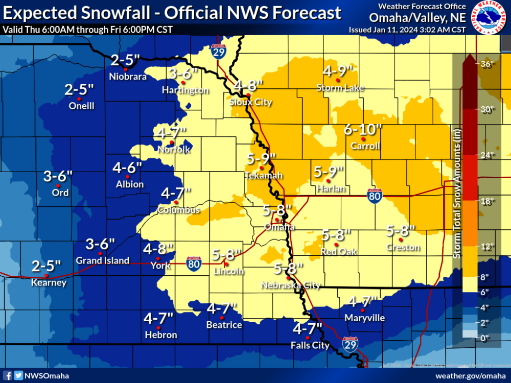
-
January 11-13 Major Winter Storm/Blizzard
Grizzcoat replied to Hoosier's topic in East of the Rockies
-
January 2024 Observations and Discussion
Grizzcoat replied to Minny_Weather's topic in East of the Rockies
From DMX AFD this morning- Details: The potent shortwave trough that brought snow to many portions of the state yesterday afternoon and evening and even our second and third snow squall warnings ever at WFO Des Moines is now centered over southern Wisconsin. -
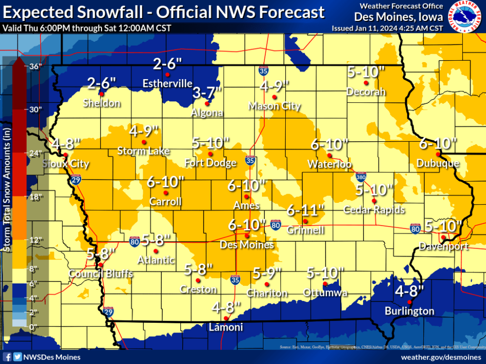
January 11-13 Major Winter Storm/Blizzard
Grizzcoat replied to Hoosier's topic in East of the Rockies
Wont post the AFD- but DMX talking Blizzard Warning potential for late FRI into SAT - but don't want to confuse the public that it would be for the entire event. One thing is certain - DMX must not believe in Wind Chill watches etc like OMX does. -
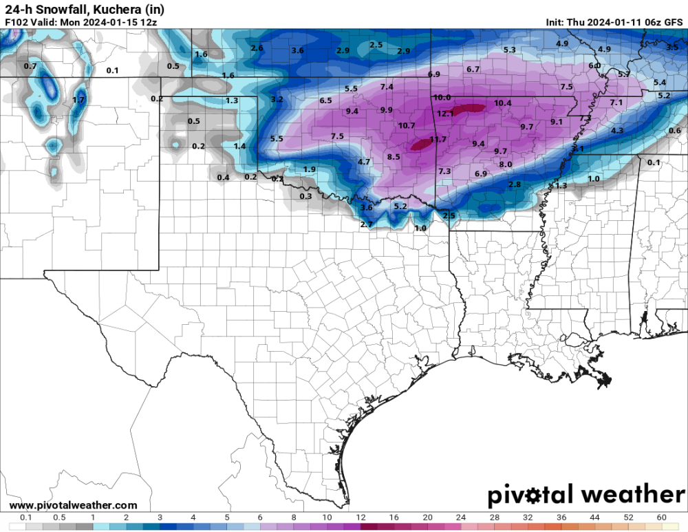
January 14-16 Major Winter Storm and Arctic Blast
Grizzcoat replied to Black Hole's topic in East of the Rockies
Love that you peeps in OK are getting what you want!!! It's difficult even here in IA to cash in on big time snows (been lucky lately) but so many things have to go just right. Congrats- Not often does one get to use a TX base map for a snow event!!! 06Z GFS hot off the press.