

Tyler Mode
-
Posts
2386 -
Joined
-
Last visited
-
Days Won
34
Everything posted by Tyler Mode
-
December 2014 Observations for the Pacific Northwest
Tyler Mode replied to stuffradio's topic in West of the Rockies
The NAM now shows a compact low as others have. It keeps it a little further south. -
December 2014 Observations for the Pacific Northwest
Tyler Mode replied to stuffradio's topic in West of the Rockies
This cool air continues to be very shallow. At my house in Battle Ground it is 46 degrees at 300'. Meanwhile, at my friend Brian's house, 2 miles east and at 500', it's 60 degrees this morning. The warm air is blowing over the top of the cool air still. It'll be a nice temp jump when this mixes out. http://www.wunderground.com/wundermap/ -
December 2014 Observations for the Pacific Northwest
Tyler Mode replied to stuffradio's topic in West of the Rockies
The EURO now shows at least a low pressure center, albeit weaker than the GFS...but it's a major step toward producing wind in the valley. -
December 2014 Observations for the Pacific Northwest
Tyler Mode replied to stuffradio's topic in West of the Rockies
10 AM Comparison 12z vs 0z More compact and stronger low on the 0z -
December 2014 Observations for the Pacific Northwest
Tyler Mode replied to stuffradio's topic in West of the Rockies
Last February was good for the PDX metro... http://weathercrazy.smugmug.com/Weather/Snowy-February-2014/i-7MCcRdv/0/L/32.%20G%20Snowy%20Front%20Yard%20NIght-L.jpg http://weathercrazy.smugmug.com/Weather/Snowy-February-2014/i-6PMMCwp/0/L/120.%20G%20Frontyard%20Misty-L.jpg -
December 2014 Observations for the Pacific Northwest
Tyler Mode replied to stuffradio's topic in West of the Rockies
Then there's this... -
December 2014 Observations for the Pacific Northwest
Tyler Mode replied to stuffradio's topic in West of the Rockies
12z GFS shows strong winds for the Oregon coast with a strong but weakening and baggy low. Gradient never lines up for the valley, but we shall see. -
December 2014 Observations for the Pacific Northwest
Tyler Mode replied to stuffradio's topic in West of the Rockies
Not the most colorful sunrise, but the clouds were interesting: http://weathercrazy.smugmug.com/Landscapes/Winter-20142015 -
December 2014 Observations for the Pacific Northwest
Tyler Mode replied to stuffradio's topic in West of the Rockies
36 this morning here in Battle Ground. Incredibly boring weather the last few days, but it's nice to take a break from the models etc. -
December 2014 Observations for the Pacific Northwest
Tyler Mode replied to stuffradio's topic in West of the Rockies
Yep...for me, 19 degrees 4 mornings ago. 52 now. -
December 2014 Observations for the Pacific Northwest
Tyler Mode replied to stuffradio's topic in West of the Rockies
It's hard to believe fog won't form though. Especially with the relatively cool ground now, and warm air overriding it. -
December 2014 Observations for the Pacific Northwest
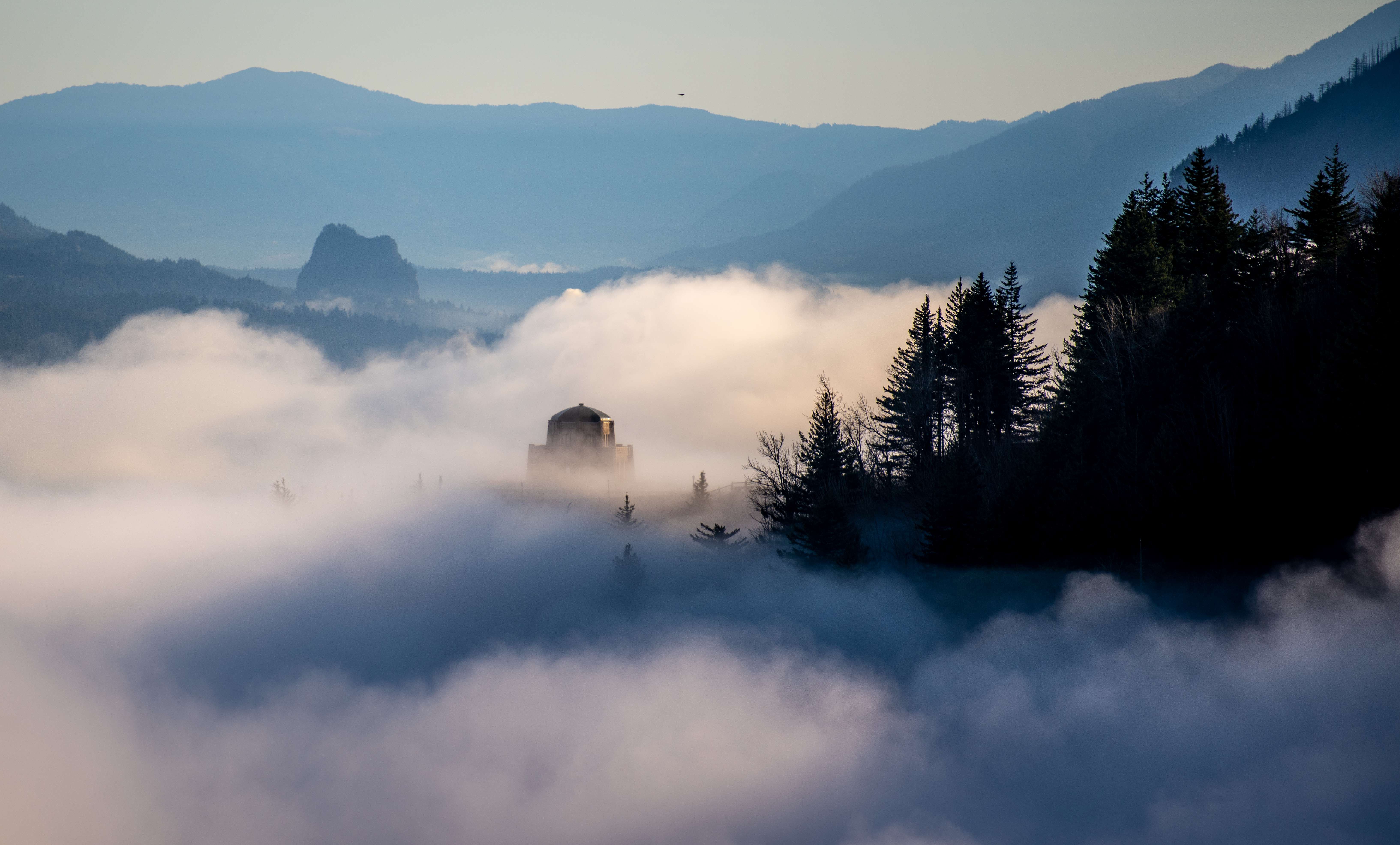
Tyler Mode replied to stuffradio's topic in West of the Rockies
The south wind finally broke through at Crown Point. 39 at 10:17, 46 at 10:27 It won't last long as the GFS shows east wind returning overnight... -
December 2014 Observations for the Pacific Northwest
Tyler Mode replied to stuffradio's topic in West of the Rockies
First westerly flow in a while kicked in around 6 AM. Temp went from 42 up to 48 rather quickly. Its going to switch at Crown Point soon too, for the first time in over a week. http://www.wrh.noaa.gov/mesowest/getobext.php?sid=D6193&table=1&banner=off -
December 2014 Observations for the Pacific Northwest
Tyler Mode replied to stuffradio's topic in West of the Rockies
Today it has switched back to snow at Trout Lake. Obviously the upper levels are finally cooling some. Too bad there wasn't more snow for the mountains. -
December 2014 Observations for the Pacific Northwest
Tyler Mode replied to stuffradio's topic in West of the Rockies
Here is a webcam picture from Trout Lake yesterday. You can clearly see a lot of ice. -
December 2014 Observations for the Pacific Northwest
Tyler Mode replied to stuffradio's topic in West of the Rockies
What a raw December day. Did make it to 41 (now) with 0.78" of rain. Mark Nelsen posted weekly maps over at KPTV and they too show cold air the last week of the month. However, they completely missed the cold back in mid November. https://fox12weather.wordpress.com/ -
December 2014 Observations for the Pacific Northwest
Tyler Mode replied to stuffradio's topic in West of the Rockies
I hate to say it, but I wouldn't mind an El Nino right now, as it seems the best pattern to at least get California some sustained rain. -
December 2014 Observations for the Pacific Northwest
Tyler Mode replied to stuffradio's topic in West of the Rockies
Looks like quite a bit of freezing rain from Crown Point (Exit 23 or so) east in the gorge. The sensor at Crown Point is now frozen as well: http://www.wrh.noaa.gov/mesowest/getobext.php?sid=D6193&table=1&banner=off -
December 2014 Observations for the Pacific Northwest
Tyler Mode replied to stuffradio's topic in West of the Rockies
A Warm Fall Data from my Minnehaha station (Records since 1996) This is September, October, November averages Average High Temp: 66.2, beating out 65.8 in 1999 Mean Temp: 56.9, beating out 55.7 in 1997 Average Low Temp: 47.2, beating out 46.2 in 1997 Some trends for the last 18 years: My average high temp for the 3 month period is down 0.8 degrees. My average low temp for the 3 month period is up 1.4 degrees. My average precip for the 3 month period is down about 2". -
December 2014 Observations for the Pacific Northwest
Tyler Mode replied to stuffradio's topic in West of the Rockies
It's more simple than you think. If the cold air is deeper than the Cascades, the cold air flows over and you can get downslope winds. If it's deep enough just to flow over the passes etc you get gap winds. If you have an inversion on the westside that is shallower than the passes, the east wind/outflow can flow right over the top. It can't be too strong of outflow though or it will mix out very quickly. There has been many times here when I see east winds 25-30 mph, and I know up at CP they are weaker than it would be because it's not being forced just through the gorge. -
December 2014 Observations for the Pacific Northwest
Tyler Mode replied to stuffradio's topic in West of the Rockies
I love this kind of stuff! I have excel sheets/graphs back to December 1996 for my Vancouver station. 4th year of my Battle Ground station on December 10th... -
December 2014 Observations for the Pacific Northwest
Tyler Mode replied to stuffradio's topic in West of the Rockies
19 for a low in Battle Ground. Then dense fog quickly formed. It was thick for much of the morning, then it burned off and more clouds rolled in. Forecast high was around 42-44, ended up at 38. No east wind here until this evening, and it's just a drift. Meanwhile at Crown Point, gusts at 90 mph on the sensor. http://www.wrh.noaa.gov/mesowest/getobext.php?sid=D6193&table=1&banner=off -
December 2014 Observations for the Pacific Northwest
Tyler Mode replied to stuffradio's topic in West of the Rockies
It's not often the skies clear after snow on the west side. This image from yesterday clearly shows the snow on the NE side of the Olympics, near Vancouver BC, and the convergence zone near Seattle. There was a dry slot between Bellingham and Seattle that I would be pissed to live in For the full size version: http://ge.ssec.wisc.edu/modis-today/index.php?satellite=t1&product=true_color&date=2014_12_01_335&overlay_sector=false&overlay_state=true&overlay_coastline=true§or=USA1&resolution=250m http://weathercrazy.smugmug.com/Weather/Snow-and-Cold-Late-November-20/i-2JNSmgH/0/L/t1.14334.USA1.143.250m-L.jpg -
79 here today briefly. Lots of people saying they are liking the cool down. I'm fine with the cool down but okay with the sun too. Really I'm waiting for that day after the first snow falls down to 6-7,000',the skies clear out and the mountains are white and the air is clean again.
-
Pics from just two days up at Mt. Rainier...the pictures don't do it justice though! http://weathercrazy.smugmug.com/Landscapes/Mt-Rainier-818-81914
