whatitdo
-
Posts
146 -
Joined
-
Last visited
Everything posted by whatitdo
-
Nov 30-Dec 2 OHV/Eastern GL's possibly historic snowstorm.
whatitdo replied to jaster220's topic in East of the Rockies
yessir it does. 7-8 3 inch plus events would be very welcomed. That's like 2 a month from december to march. Hope it pans out. I feel like bad luck sometimes don't want south busts to follow me haha -
Nov 30-Dec 2 OHV/Eastern GL's possibly historic snowstorm.
whatitdo replied to jaster220's topic in East of the Rockies
May not belong in right thread but tell me @jaster220 how often in the winter months is there a potential snowfall threat to track in SW Michigan? Like how many snow events a month is common here I guess -
I feel like Decembers have just been terrible these last couple of winters or so for much of the CONUS. Is there a explanation from verified meteorologists or atmospheric scientists why? Climate change? First third looks very meh.
-
Nov 30-Dec 2 OHV/Eastern GL's possibly historic snowstorm.
whatitdo replied to jaster220's topic in East of the Rockies
GRR NWS: .DISCUSSION...(This evening through next Sunday) Issued at 316 PM EST Sun Nov 29 2020 -- Snow Potential for Southeast Lower Michigan Monday into Tuesday -- Two potential storms may have at least peripheral effects for southwest Lower Michigan, one early in the week and another next weekend. The track of the surface low on Monday and Tuesday across eastern Ohio/western Pennsylvania will keep the deformation axis and best f-gen forcing across central Ohio and southeast Lower Michigan on Monday lingering into Tuesday as a trowal persists across the eastern Great Lakes. Lake enhanced snow showers in northwest flow will be affecting the southwest forecast area during this time as well. So POPs Monday into Tuesday will be highest across the SE zones especially Jackson County, along with the SW zones especially Van Buren County. Accumulations and impacts in our forecast area should be low as the stronger mesoscale snow bands are expected to remain off to the east of the forecast area where the best mid level F-gen will be, while the heavier lake effect bands remain to the southwest, across Berrien County and northern Indiana. The storm pulls away Tuesday night while our attention turns to a low cutting off across the Southern Plains. -- Lowering chances for a Big Storm next weekend -- The Southern Plains low is now trending to move along the Gulf Coast and take longer to phase with a northern stream low. This greater separation and slower phasing means the bulk of the heavier precipitation remains south and east of Lower Michigan. There could still be some light snow or snow showers as the northern stream low moves through late in the weekend, but this is looking like less of a significant storm for Lower Michigan. && You in the right spot thus far @Niko this winter! -
Probably will seeing that im out of town (SW michigan) from the 17-23rd lol. Mark it!
-
Nov 30-Dec 2 OHV/Eastern GL's possibly historic snowstorm.
whatitdo replied to jaster220's topic in East of the Rockies
Judging by today's 12z euro he's right haha; further east the better for snow totals -
Nov 30-Dec 2 OHV/Eastern GL's possibly historic snowstorm.
whatitdo replied to jaster220's topic in East of the Rockies
hahahah same. I think the key is to also pay attention to NWS office and what they suspect. Naturally their totals are probably half of what is shown here but they are experts for a reason -
Nov 30-Dec 2 OHV/Eastern GL's possibly historic snowstorm.
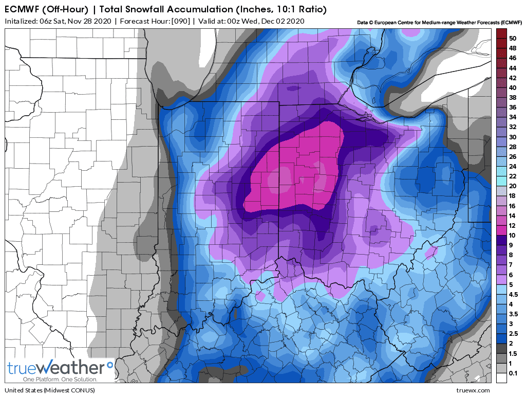
whatitdo replied to jaster220's topic in East of the Rockies
06z euro. Also west. @Niko@jaster220 Nice totals across the board
-
Nov 30-Dec 2 OHV/Eastern GL's possibly historic snowstorm.
whatitdo replied to jaster220's topic in East of the Rockies
18z euro more west..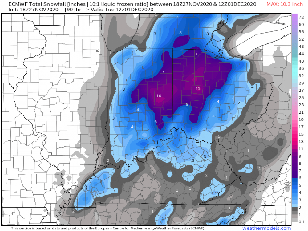
-
Nov 30-Dec 2 OHV/Eastern GL's possibly historic snowstorm.
whatitdo replied to jaster220's topic in East of the Rockies
If the euro doesn’t stop the trend on this run and run tonight may be time to put a fork in it. Not that I haven’t lost all confidence in it already lol -
Nov 30-Dec 2 OHV/Eastern GL's possibly historic snowstorm.
whatitdo replied to jaster220's topic in East of the Rockies
If the models don’t shift back west today it may be over for west michigan. Would lake effect still take place though even if the track misses to the east? -
Nov 30-Dec 2 OHV/Eastern GL's possibly historic snowstorm.
whatitdo replied to jaster220's topic in East of the Rockies
That euro is underwhelming for SW michigan. -
Looks like they think it’s less likely to hit the midwest despite euro’s consistency in the track to do just that. What you thinking?
-
Hoping this doesn’t happen - cold air not being in place with a nice system is all too familiar for me!
-
Weird since it’s been picking it up pretty adamantly past couple days. Wonder what happened
-
None of the snowfall stuck here in kzoo and it unfortunately reminds me of the many snowfall busts the south sees (to be fair this system kept shifting south/east of here as it got closer). Still waiting for first snowfall greater than an inch; but hopeful that next weekend and December delivers
-
Good stuff, man. I found this tweet rather interesting as well: In the last 20 years, accumulating snow >1 inch here has happened after December 15th only once back in 2012. Our average date would actually be tomorrow. Seems like we're due soon eh?
-
Maybe a little something early next week for snow belt areas in Michigan?
-
I appreciate the warm welcomes! Thanks, will check this out. It's in my blood to refrain from getting too excited, but I'd be lying if I said I haven't caught myself wishing for some legit flakes soon. That dusting on the 1st was a nice lil treat.
-
Moved to Kalamazoo area pretty recently from the southeast. Always been a huge snow and weather fan, and I'm sure even the worst of the winters here will exceed what I've been used to (average snowfall per season around 5-8 inches lol, I see it is around 60 inches here). I have one observation and one question 1) the occasional gales that happen in the fall are fabulous. Makes me appreciate the ferocity of the great lakes that im sure are not known to many in the country 2) what consists of a winter storm warning in SW Michigan and how often do you get them in a season? Where I was, this was 3 inches+ (in 12 hours) and 4 inches+ (in 24 hours). Winter weather advisories were 1-3 inches. I've had many bare winters. These were the only winter weather definitions I've been accustomed to and I'm sure there are far more definitions that I'm unfamiliar with (blizzards, lake effect, etc) that I want to get familiar with haha Apologies if I've posted this in the wrong thread