


OKwx2k4
-
Posts
5472 -
Joined
-
Last visited
-
Days Won
33
Posts posted by OKwx2k4
-
-
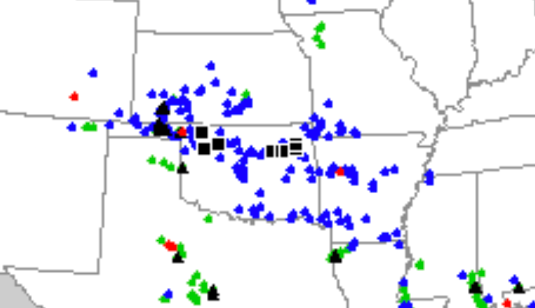
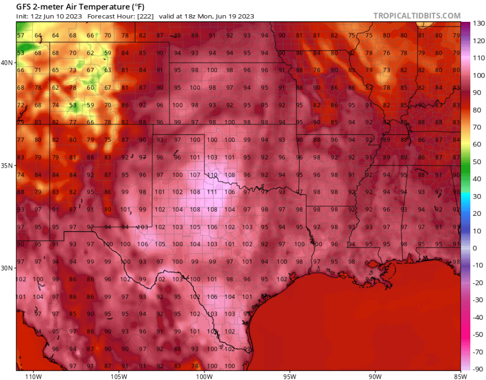
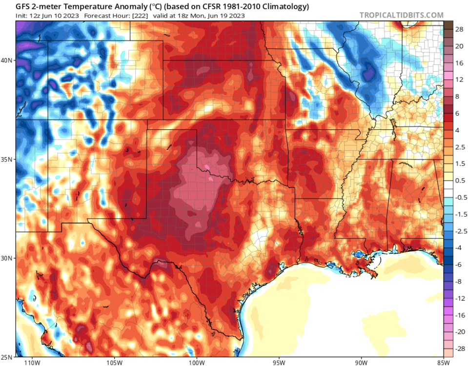
Nasty hot weather for the next couple of days in Texas. Oklahoma and Arkansas look variable over the same span. Hoping that at things get really cranking with the heat, we get a good cold front right down the middle.
-
14 hours ago, Tom said:
Checking into the severe wx reports, it appears @OKwx2k4 got hail and wind out of that line of storms... @Clinton is up in W MO area....
@Black Hole, overnight storms are the worst...that line eventually made it up to Branson around 3:30am and had some loud claps our rolling thunder. Woke me up! Glad your safe and have power...No Power in a hot and humid airmass is NOT fun.
Yeah. I picked up some hail and damaging winds. Lots of trees damaged. Some blown over completely. Was a wild night.
-
 5
5
-
-
21 hours ago, Andie said:
Just heard an interview from a Kansas farmer experiencing their worst harvest in recorded history. His harvest is a total bust.
Meantime Russia is having an exceptional harvest.
Just an example of weather/climate is history.Global climate flip. At least where I'm observing or my opinion. Temporary or multidecadal is my question.
-
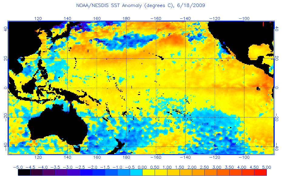
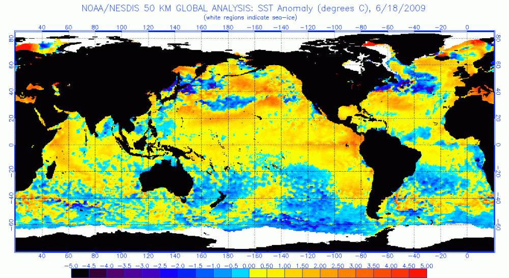 Here's a side-by-side of 2009 and today that are more comparable than the two i posted in a previous post.

-
1
-
-
Great write-up there.
The US being surrounded by cold water this year and in the Baja region are majorly different, along with the orientation of the warming in the N.Pac. These are and will be important factors going forward. Anomalous and massive warm pooling in the NE Pac is also absent. These point to a cooler long-term and an upcoming reversal of our "heat over the heartland" setup.
The Atlantic is in full Niño suppression mode, too. Doesn't matter how much heat you're working with in a suppressed/high shear environment, you can't make a hurricane that way.
Phil pointed out some excellent stuff also. Very excellent.
Only disagreement i have (and absolutely could be wrong) is that in comparing 2009 to this one, we didn't see a Modoki style setup at first. 1.2 wasn't as warm though and that may be the difference-maker.
-
1
-
-
Later in the run today....
This quickly transitions north and east. Not looking forward to it but hoping it is squashed soon after.
-
1
-
 3
3
-
 1
1
-
-
6 minutes ago, Clinton said:
96 and muggy means no shortage of energy, hopefully you avoid the hail and get some nice rains.
Red River area looks to remain active going into next week.

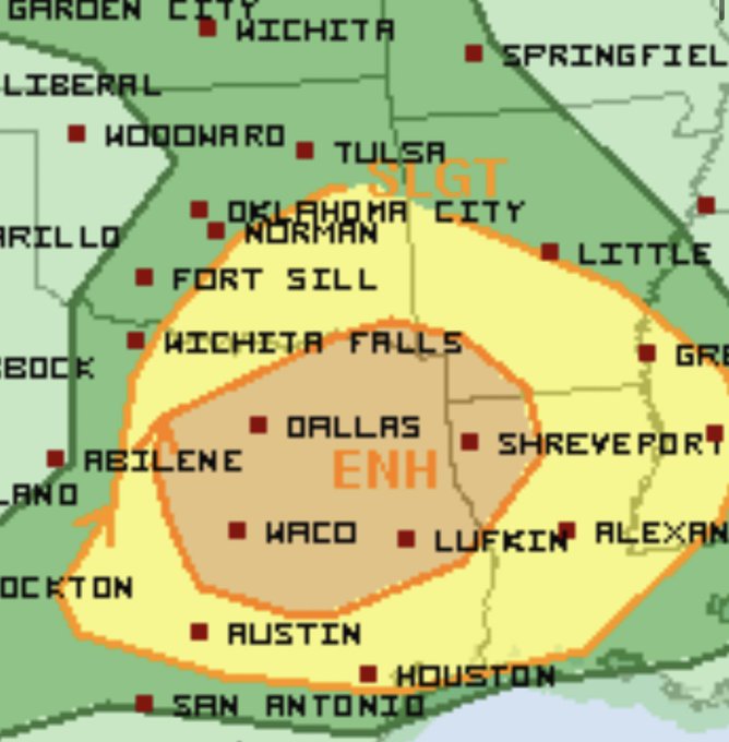
That's a pretty good sized enhanced risk area.
By the end of latest GFS run, Andie and myself may have a rainfall contest. Bad news is that part of it comes from a hurricane.
Storming at my place now. Fun stuff.
-
3
-
 1
1
-
-
On 6/8/2023 at 1:45 PM, Tom said:
The JMA weeklies for Week 2 look hot and dry for TX/OK and the S Plains...cooler/wetter for the Upper MW...MW and Plains near normal with precip.
Things change for Week 3-4....big trough sets up over eastern CONUS and its cooler/wetter for much of the Sub...
Little two week blast of heat before June closes. Will feel pretty summerlike after all these storms pass.
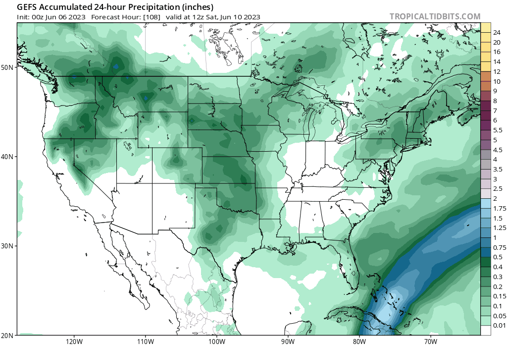
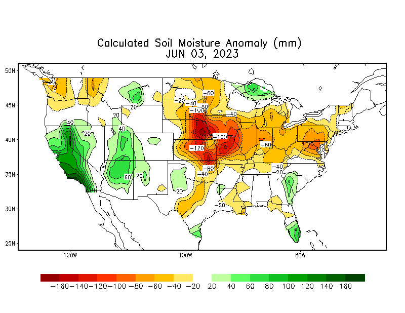
By the drought map posted in another post above, the rain is right on time. Short-term surface drought conditions are in effect.
-
2
-
-
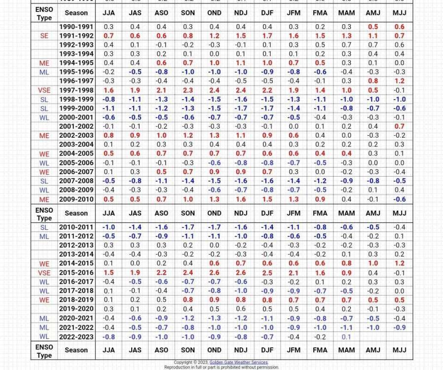
A quick look at the El Niño/La Niña Intensities and years would lead me to believe that negative/neutral or weak Niña episodes actually produce more icing events. This is likely due to the cold air source location in La Niña winters and the cold layer of our atmosphere being more shallow or less dense. La Niña doesn't often trigger an upstream blocking episode to contain the deep cold over our continent or Canada. I think this is right. May check me on it. I know 2010 and 11s blocking episodes were anomalous. Those were post-Nino, but in a La Niña that made the whole Pacific cold, if i recall it rightly.
-
1
-
-
On 6/5/2023 at 9:30 PM, Black Hole said:
I suppose like everything else around here, it's a delicate balance. If that southern jet is modified in the wrong way we just get flooded with Pacific air it seems.
What about a general ice storm climatology? That's a hard thing to look up for some reason. Does it change during ninos?Been my experience that ice events either precede or follow Niños. Ice storms here in 1999, 2000 and 2001, then January 2009 are pretty major ones from memory.
(My opinion...)They are hard to look up because their effects, if not in a large city, are recounted, documented by locals who went through them but not so much by the areas around them.
There's a YouTube video of NWA and Northeast Oklahoma and my hometown in Jsnuary 2009s (winter 2008-09) ice storm. Its pretty wild stuff. It was scary.
I remember reading an ice storm study that looked at tree rings to determine which years saw ice events and their effects. Other than that, i don't know of much to find on the topic.
-
2
-
-
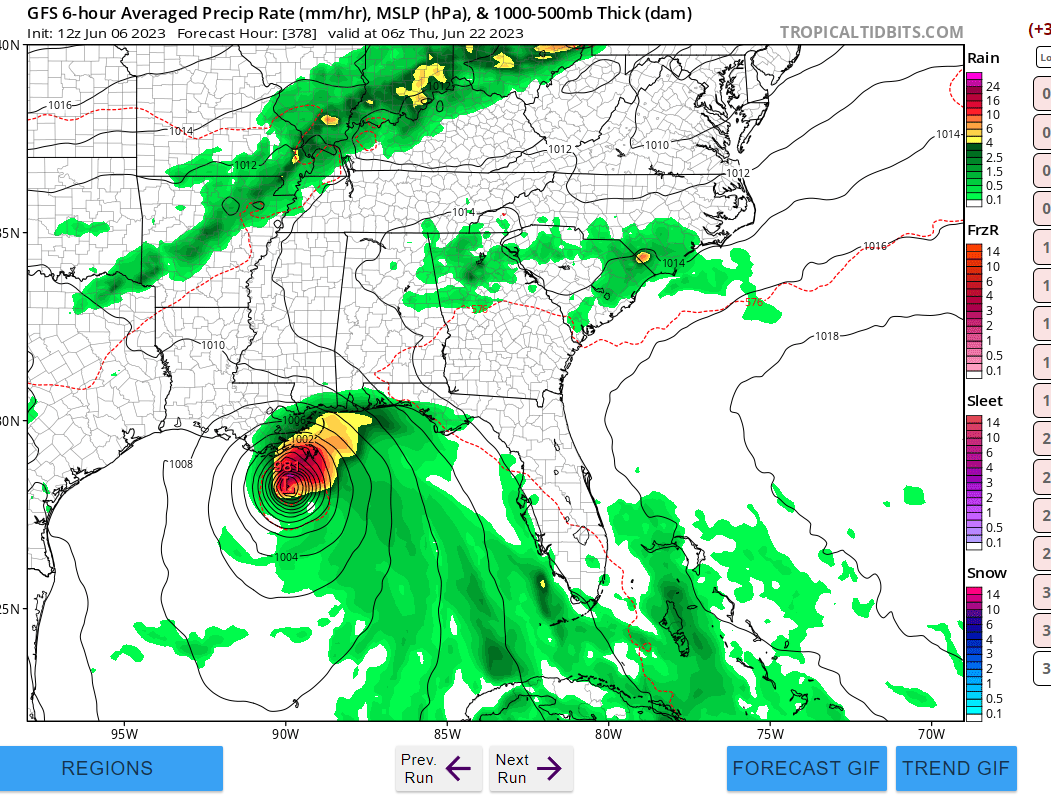
6 hours ago, Thunder98 said:
The GFS is showing a tropical cyclone hitting LA in fantasyland.

Mini Katrina. Well....
Its never good to see a left turning tropical cyclone/hurricane. Would fit part of my summer predictions, though, if it came true.
-
10 hours ago, Tom said:
Good Day all! Yesterday, PHX torched and hit a season high of 107F. Locally, it is a cool 67F this morning and quite refreshing. I smelled the wild fires in the air that are burning near the HWY 87 Beeline not far from my place. In the mornings, while winds are calm, you can see the smoke layer on the camera shots across the valley acting like a "bowl", pooling all the smoke. Just to let you know, the wild fire season isn't as bad as years past. They are manageable and the continued Monsoon rains are really helping the situation.
Is there a pattern change looming? Finally, a storm system will traverse out of the 4 Corners/Rockies and towards the GL's/OHV region by this weekend. The models are showing what was a very common theme over the course of the last cold season as a weak SLP will form out in the Sb Plains and track East bringing a ribbon of much needed moisture to the Eastern Sub. Some signs of a summer version OHV cutter??
I'm wondering if it really makes sense that all models are totally reversing this pattern in the 10-15 day ranges, putting a huge ridge in its place across the heartland and up through the lakes. I don't know if I can agree with them just yet. We'll see.
I'm truly glad to see precipitation in any form on the drought regions.
-
1
-
-
On 6/4/2023 at 7:58 PM, Phil said:
Stuff really drying out here. Been a dry pattern here since last October, and now a top-5 driest Jan-May on record since the mid-19th century.
Looks like another wall of smoke from Canada will move in tomorrow afternoon. Have never seen so much wildfire smoke in June before.
All bad omens, I fear. This isn’t how cool/wet niño summers typically begin.
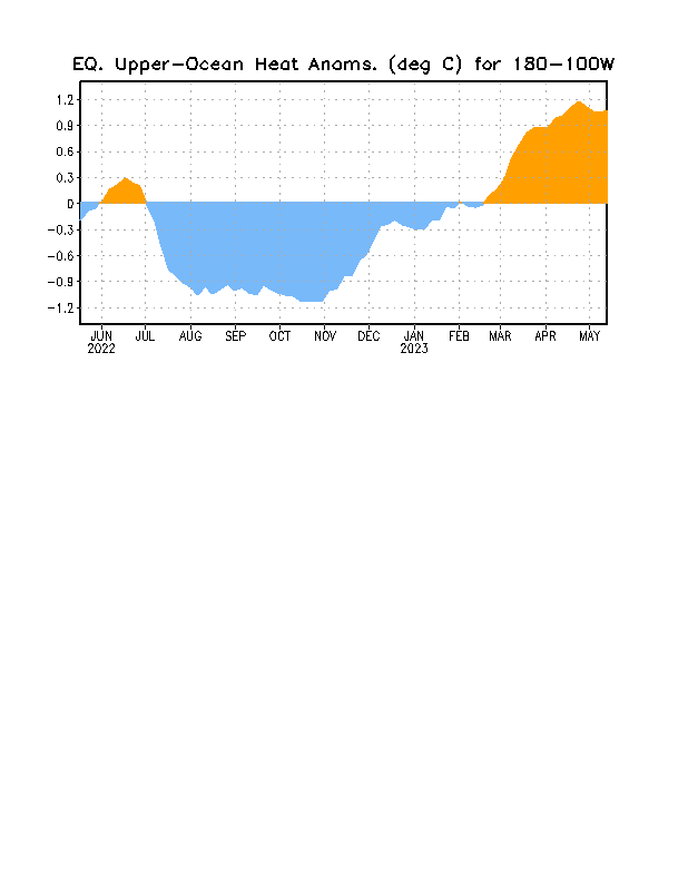
Well, I'm noticing that the eastern flank of Niño has really spiked the last few days, too. I hope this fades and becomes central based as we go, but I could be wrong.
I definitely do not downplay the significance of our massive rainfall deficit region either. More than anomalous would be a great way to put it.
-
3
-
-
1 hour ago, Andie said:
Correct me, but I believe it was 2009 we had a serious Nino winter. Loads of snow.
It will be interesting to see how this year stacks up. So far a relatively cool early summer. We’re seriously enjoying it. We’re getting enough rain so everything is green and lush.
More please.Yeah. 2009-10 was the prettiest winter in a long time for many people. That whole late summer, autumn and winter were awesome weather it seemed like.
-
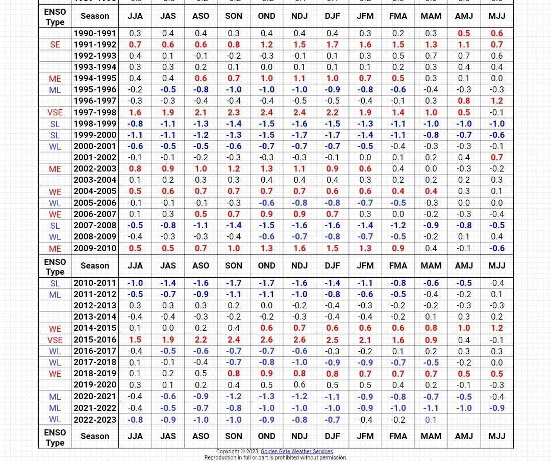
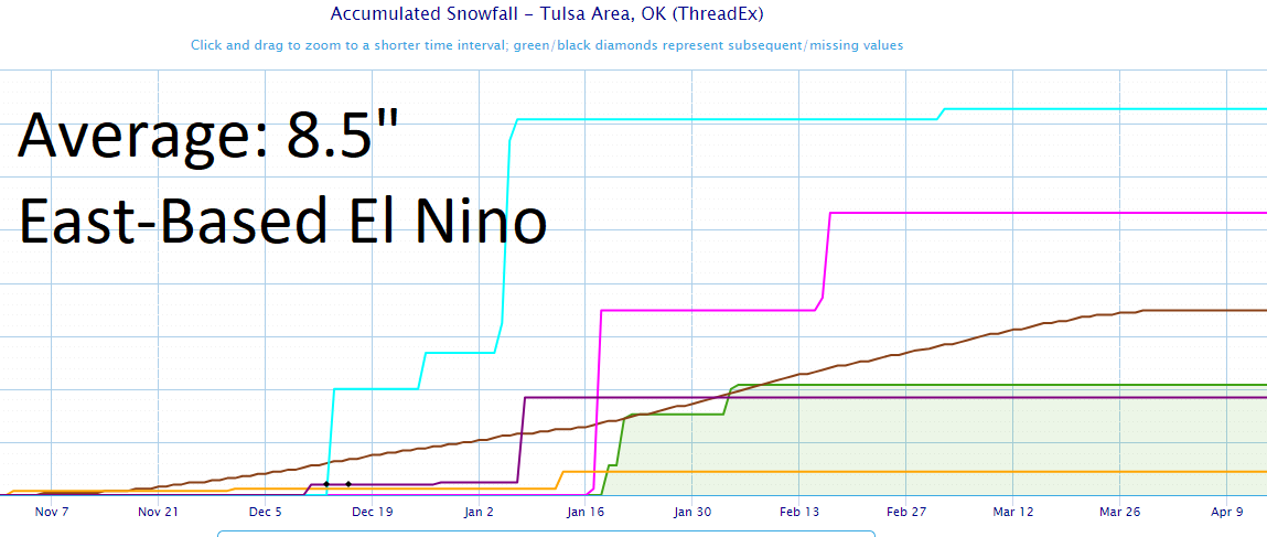
1 hour ago, Black Hole said:
Some snow stats for Tulsa in El Nino's. It looks like Modoki El Nino's are in fact pretty good here as OKwx2k4 noted. The signal is more mixed for strong or east based El Ninos. Plenty of reason for optimism going forward as most El Ninos are more Modoki than east based/strong.

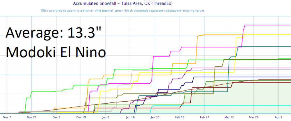
Its a very marked pattern difference in the two. My theory is that in Modoki, the southern branch has less heat but retains the moisture load allowing for slower moving large storms and more precip in our area. The last Modoki was in 2009-10, I think. By the time a major Niño or East-based Niños hotbox Pacific influence on our atmosphere wanes, if the Pacific is in agreeing pdo phase, it's usually very late into the winter before we see snowfall.
-
3 hours ago, Tom said:
Gosh, if that "Split Flow" in the NE PAC can really become a dominant jet stream pattern of next autumn's LRC...Look out below!
100 percent correct.
")
-
3 hours ago, Black Hole said:
What's the typical El Nino effect for my part of the world, especially for winter?
In our area, humid moist in summer BUT cool, dry autumn then cold, wet, snowy in winter. In extreme + Nino episodes with a huge positive pdo signature, it's like the tropics invaded us. Pacific air flooding us for days. In a weaker, more moderate or central Pacific Niño (Modoki), the southern branch can't continually pull hot air off and we see a year like 2009-10 happen. Extreme or very weak Nino episodes are pretty much in the equal chances category. N.Pac ocean temps are a huge part of this equation as well. That's one that has been debated since the great warm pool of 2013-14 and part of '15, known as "the blob" for a time.
-
1
-
-
2 hours ago, OttumwaSnomow said:
I did a little research. Since 2003 Ottumwa Iowa has had 4 sopping wet years, 2007, 2008, 2009, 2010 in a row! It has had 10 dry years well below avg precip. And about 6 years 1 to 3 inches from normal. But here the killer we have had several very wet months outside the growing season. Like a 8 inch October and a 8 inch December. And in general the winters are wetter than normal. So what all this mean? Without a doubt the may to septembers have leaned way way drier than avg. Particularly is this true of July and Aug!!! I haven't specifically looked that up but its a fact that there has been few very wet weeks in July and Aug for many years. This is reflected on us almost perennially being on the drough monitor!
This is awesome research and also an interesting trend over the last two decades. I wonder if this is a pattern that will reverse over the coming years or grow. Seems likely that eventually it would shift or reverse altogether at some point, in my opinion.
-
2
-
-
4 hours ago, Tom said:
Another hot one back in Chi, ORD topped out at 91F (4 days of 91F day highs)...looks like Summer has come early this year...hmmm, is that 1977 going to be an analog for next cold season? Would be nice! I believe 1977-78 was a weak Nino that came on late in Summer but especially Autumn/Winter.
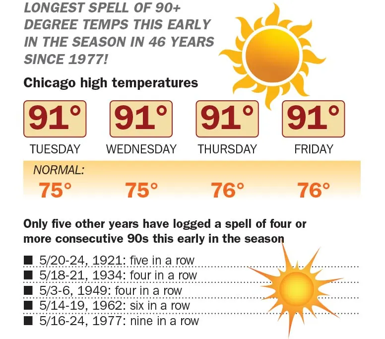
76-77 and 77-78 were the twin weak-mod Niño episodes that marked the great climate shift.
I'll have an order of 77 with a side of 1995. With a 2009 as a cherry on the top.
I find it remarkable that we talked a few times about the end of last year and beginning of this one about 2008-09 and things are still really tracking in that way...In my opinion anyway.
-
2
-
-
11 hours ago, Tom said:
We are heading into an unusually "cooler" weather pattern next week as a cut off trough moves over head ushering in breezy conditions and temps in the low 90's mid week! Wonderful temps for this time of year when you can easily see highs in the 100's, but not this year!
@Clinton, just like you mentioned in your previous post, this pattern continues to repeat just like we saw back in the Winter months. I mean, how many times did we see troughs slide down the west coast and then track into the SW/4 corners? This is like the "up-teenth" time since the Autumn...#cycles
It looks to continue reloading for the forseeable future, too. Split-flow for days across the Pacific.
-
3
-
-
Thrilled to see precip currectly traversing the stack of central states this evening and tonight!
-
3
-
-
On 5/27/2023 at 10:11 AM, gimmesnow said:
Oh man I hope next winter is good. I ended my snowboard season in Lutsen with a high level snowboard instructor who taught me so much stuff, only for everything to be put away for the season.
If enso peaks by October, you will very likely get your wish.
-
2
-
-
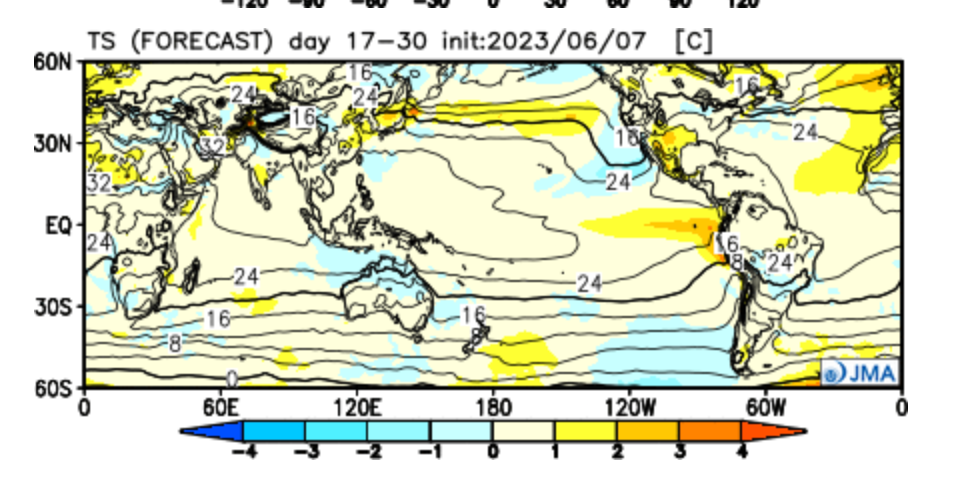
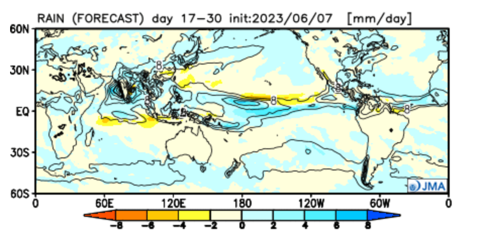
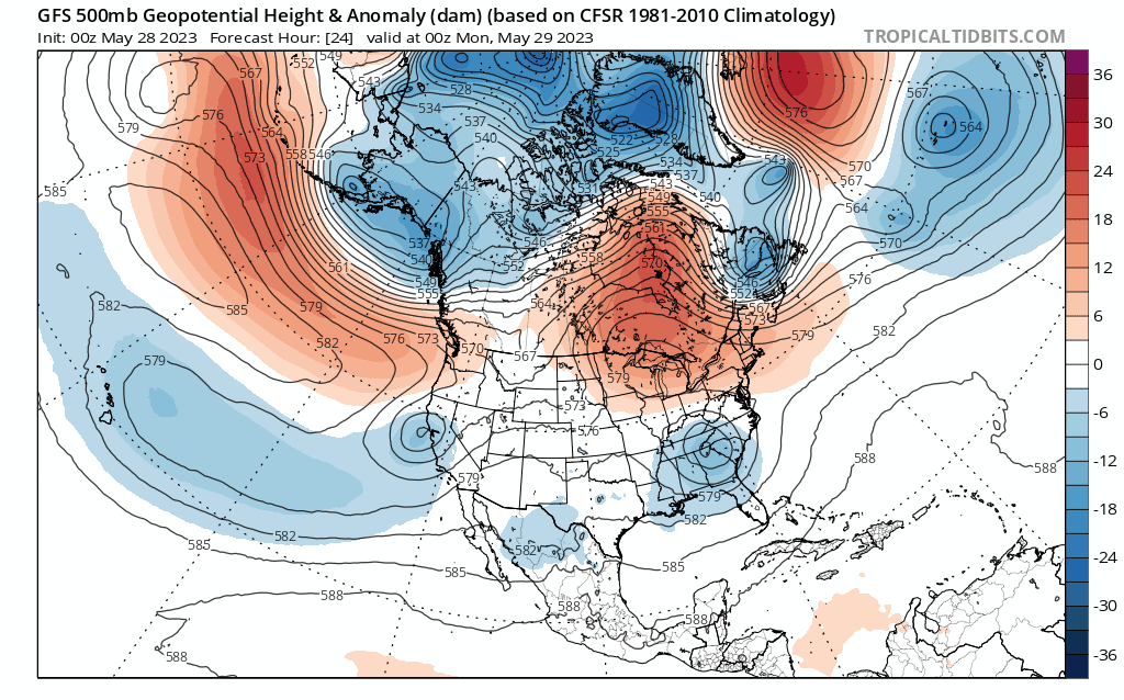
A little more info....
We are very nearly at the tri-monthly threshold to make it official.

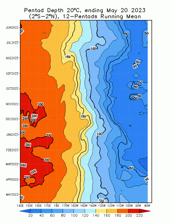
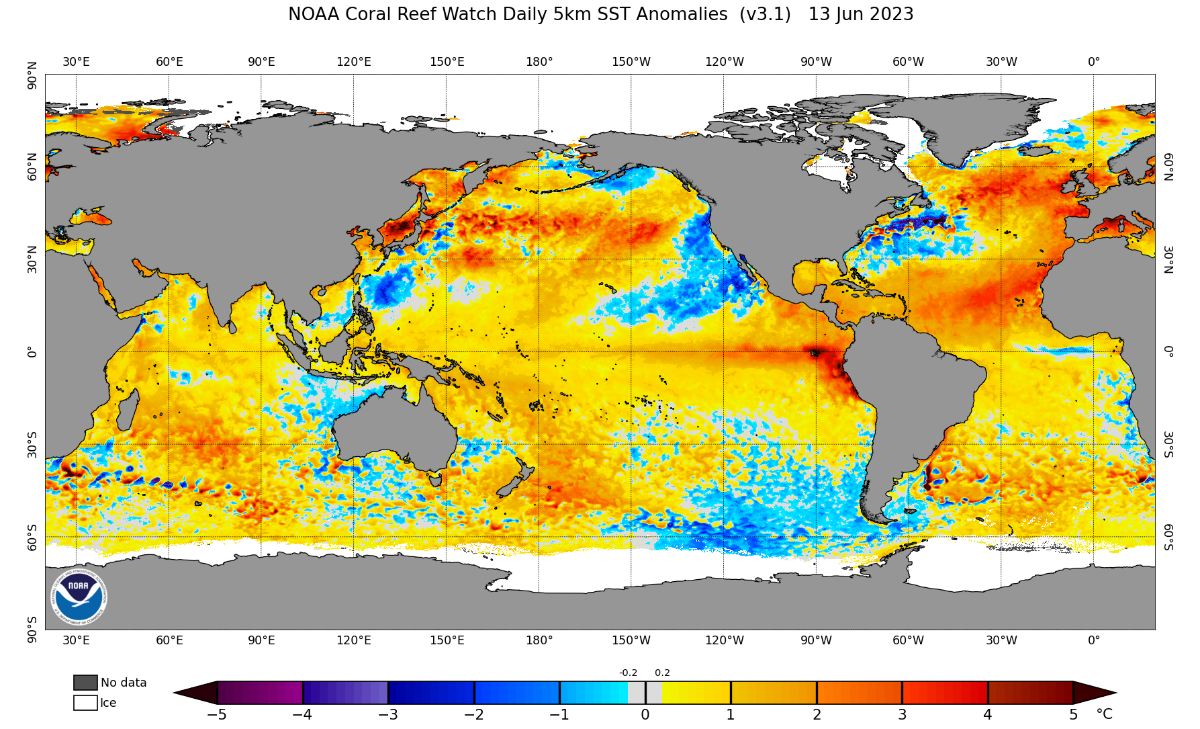
Although heat is surfacing in the east at a rapid rate, it has no depth to supply it...(last image). Lastly, looky at this forecast....(next image). Sorry they're out of order. They didn't post correctly.

-
2
-
-
Also at this...
Tom wrote: "Oh, I'd also be stoked to see the NE PAC warm and hug the coastline in NW NAMER...we haven't had this type of patter for 3 or more years from all the Nina's and a dominant N PAC flow. Maybe nature is shaking things up this year???"
can you say "near permanent Aleutian Low"? Yes please! I'm going to get excited if I don't stop. Lol. That's a southern branch monsters setup if I ever saw it with a delivery path right through my house. All the fuel storms need on the Pac with a reserve in the GzoM. Awesome stuff!!
Alsi, when the oceans warm in a certain pattern, it causes a warm ocean/cold continents pattern or positive TNH pattern. May last two decades, may last two years, but I'll put everything I have on the belief that we witnessed a dual-hemispheric climate shift.


June 2023 Observations & Discussions
in East of the Rockies
Posted
The video is great. Those are excellent explanations for our unusual pattern.
I have been confused as well on our pattern and why in a full El Nino we are struggling. It's pretty anomalous on a national scale, to say the least.
Some stuff, no matter how hard you try or good you are, you can't call it.