


OKwx2k4
-
Posts
5470 -
Joined
-
Last visited
-
Days Won
33
Posts posted by OKwx2k4
-
-
7 hours ago, Black Hole said:
It was 1F at my place again overnight, but -3F at the Tulsa airport which is a record for the date. Looks like we will set another record low high today and quite possibly one last record low tomorrow morning before we moderate. It's been a good run for temperatures.
I'd say this event has definitely hit all of my personal "checkboxes" for great winter weather. I can be satisfied with it.
-
 4
4
-
-
May top out around 9 degrees today. Expecting to see expecting temps to start to decrease soon.
-
- Popular Post
34 minutes ago, Black Hole said:Of note the high was just 5F here today. The airport was probably 6F, one of the coldest ever recorded.
My high temp according to the mesonet was 4, but I spent most of the time I was awake at or around 1 degree.
The total snow here actually impressed me. I'd say I'm just over 2 inches. Everything came together perfectly.
-
10
-
Definitely into some good snow here on the eastern edge of OK. Going to add up pretty quickly at this pace.
-
5
-
 1
1
-
-
7 minutes ago, Black Hole said:
Here is the "last call" for 12z model runs, holding onto 1-3" for me.
Sitting under about 3 here in most of those. Not a bad last look.
I see the radars filling in as everything saturates, so only a matter of time now. I think 2-3 is a good call for me.
Yeah, that snow out by KVNX is already overperforming. Definitely a win.
-
3
-
-
53 minutes ago, Black Hole said:
The HRRR had tried to take it all away overnight but now its back with some. At least for my area I don't see any reason to change what I said yesterday. The only thing left to do is wait and see what happens now.
Yeah. It was alone in that regard and that's why I kinda didn't hold much value in it.
Looking at returns across the state, we have moisture making its way through, so we'll see how it goes. Actually looks early to me, so also just watching and waiting now.
I'm sure of one thing. It's ridiculously cold.
-
 3
3
-
-
5 hours ago, Black Hole said:
Last minute model trends are trying to lower totals more to the 0.5-2" range for here. The reality is with high snow ratios and several chances the next few days there are opportunities to overperform, we just have to hope one of them works out. I'll be expecting the under, but of course hopeful to get lucky. If it can snow enough to cover the grass I'll call that a "success".
Yeah. Brown cold is the worst kind.
I'm hoping to get a bit in to at least kind of justify this cold. Lol.
-
1
-
-
Really honing in on a forecast of 1 to 3 inches here per all guidance and analysis.
Like @Black Holementioned in a earlier post, convective snow looks possible in some places and that may be the kicker on whether I get a good amount or break into wsw criteria for snow.
I think the combined possibility of snow with the temperatures is enough, but could be wrong.
-
2
-
-
3 hours ago, Black Hole said:
For the 00z models so far (Kuchara algorithm) I am shown to get 1" CMC, 4-5" GFS and ICON. Amounts still trending down...
Yeah, you covered it well. One of the most sudden model disappointments of all time here. What a difference 12 hours makes.
-
1
-
-
Running a little ahead of our two storms to start things off down here for the year, I want to point out the third part....
It a week, it looks like we're going to see a beast, per Euro. Holy moly. Really starting to believe this is a reality.
-
I may get lucky and spike another little 2 inch round of snow out of this first storm.
Will be a perfect event to set up the events to follow.
-
4
-
-
Starting to look more and more like I'm going to see a blizzard here in Eastern OK by day 10. That's very wild. Very.
-
5
-
 1
1
-
-
So, Euro and GFS both going to an outcome I anticipate with a snowpack locked in to my North. Really feel as though we may see something pretty radical over the ozarks of Oklahoma and a few other areas what havent yet gotten snow getting to participate in the next 10 days with the rounds of weather and solid cold anticipated.
-
3
-
-
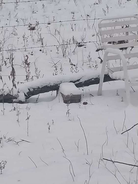
I drove home from work in the snow at 6 this morning and it was pretty cool. Like driving through a snowglobe tunnel. Lol.
It wasn't possible for me to get a good measurement because of ground temps and a lot falling right at or near freezing, but I'd estimate around 2 inches fell here really quickly. Went from near nothing on roads to plowable in 30 mins.
It was big chicken feather stuff falling for well over an hour. Like driving through concrete though. Like mountain snow, I guess. Was a beautiful first snow of 2024! Here's to a lot more!
-
5
-
1
-
-
1 hour ago, Hawkeye said:
Hey everyone. You were probably wondering why I disappeared. Blame Mediacom cable. On December 26th, my internet crapped out. Unfortunately, because I was the only customer affected, I was put at the bottom of the priority list and it took a week to get someone here to check on the problem. Another two days later, another guy came to fix it. It turns out the issue was a simple loose screw on one of the poles. It could have been fixed in a few minutes, but instead I had to be without internet for nine f'ing days.

Welcome back. Yeah, I'd have an issue or two with patience after a thing like that. Wow.
-
35 minutes ago, Black Hole said:
Your fortune is my misfortune ha. Mostly forgettable ECMWF run for me, but I was wowed by that insane cold air outbreak into the PNW.
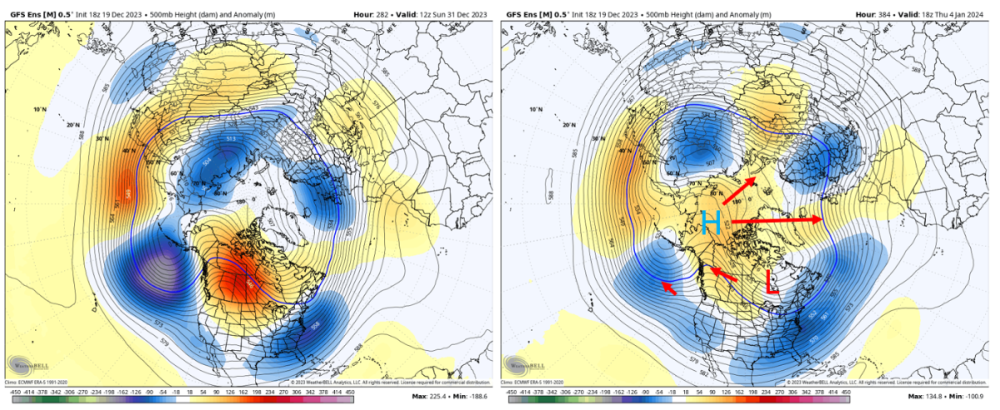
I think in general the northern Plains will do better after the system on the 10th. The coast-to-coast trough should lift the storm track north since the flow is quicker and there isn't anything to force the storms south at that point.It'll be interesting to see if the Euro comes in line with the GFS solutions after this first event here.
What's setting up is a blitz like 2009 or 2013-14, imo. Will be interesting also to see if the dome of cold and snow in the center of the country can, or if it is what's ultimately going to keep the storms developing and running the edge of the snowpack line.
Going to be hard to move that much cold out very fast.
-
1
-
-
5 hours ago, Black Hole said:
The latest GFS antics for my area. That's a blizzard if I ever saw one!

The upcoming setup looks perfect for something big to roll through, so we shall see.
Encouraging to say the least. Get the white stuff, no extreme cold following. Nice times, hopefully. Would be fun to see a massive blizzard.
-
2
-
-
6 hours ago, Black Hole said:
GFS in the long range pumped up some eastern ridging instead of a coast-to-coast trough allowing this beauty to spin up. That is the main thing I am hoping to see more model guidance show as it will really open up some possibilities!
Oh my. I don't have to add anything to this other than that's where I've expected this pattern to go. Just getting the right amount of suppression will be key.
-
16 hours ago, Tom said:
@Black Hole @OKwx2k4...could there be a NYE and/or Day wintry system brewing your way??? There is a system showing up and fits the pattern to race over the 4 corners on NYE and then possibly bring some white gold down your way. The 0z Euro Op is flashing the potential. I will add, that the period between Jan 3rd - 6th is looking like the best set up of the season for a real Winter storm down your way. Plenty cold will infiltrate the pattern by then.
I've thought about this as the start of my winter since a couple months ago so it fits, but will see how it all shakes out.
-
 2
2
-
-
7 hours ago, Black Hole said:
Here is the 18z GFS extended showing the beginnings of the pattern change I've been expecting. Retrogression of the central Canada ridge and building heights across the arctic should result in lowering heights north of us (mostly past the end of the run) and cooler air spilling south.
Slow but steady. I think we're still headed for a good winter after Christmas.
When Alaska starts going warm and that trough breaks, it'll "slosh" over to us and hopefully lock in.
-
3
-
1
-
-
10 minutes ago, hawkstwelve said:
Love seeing these continued big swings towards colder (than initially expected) conditions for Christmas.
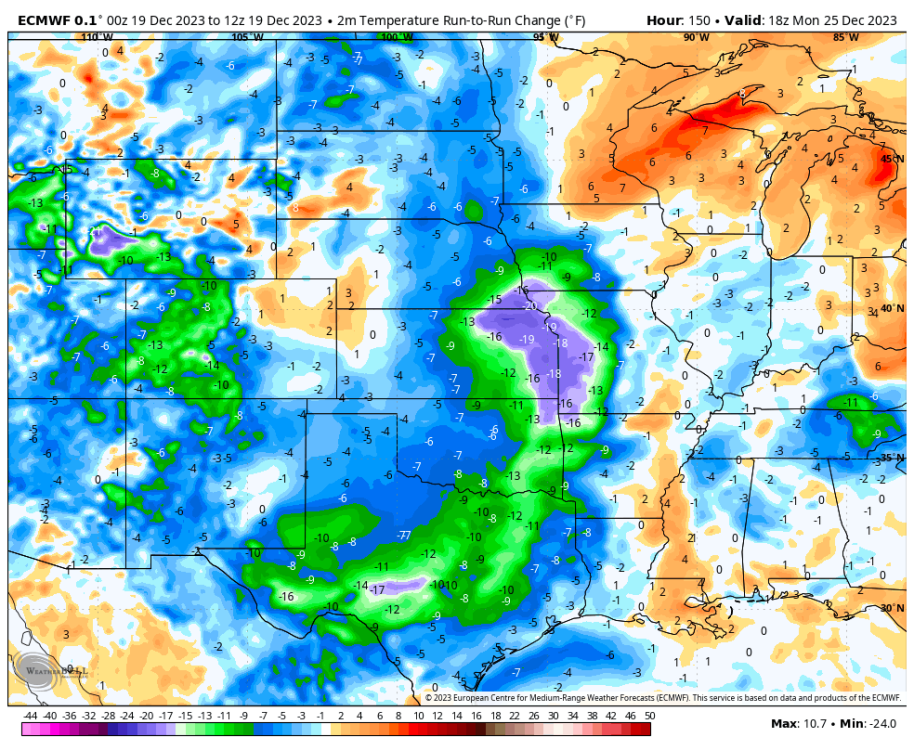
Beginning to look a lot more like Christmas. Awesome.
-
4
-
-
7 hours ago, mlgamer said:
I agree. Also, if I were to think of a similar "harsh" December for me it would be 1983 and 1989.
December 1983 was very cold and snowy start to finish.
December 1989 was very interesting. It was pretty mild on the front and backend with a bitter cold snap in the middle of the month Dec 11-24. Topeka set it's all time record low of -26 on December 23 and had a high of 46 on Christmas Day. The temp had climbed 72 degrees in basically two days.
The 1983-84 cold spells are one of the longest and harshest in Oklahoma history. January 1984's cold wave was smaller, but I joke that it's likely the reason I was born because in mid-October 1984, there I was. Lol. Must be why I like cold and snow so much.
-
2
-
 1
1
-
-
1 hour ago, mlgamer said:
China appears to be enduring a harsh December (all part of that recent Siberian cold blob) which reminded me of their severe winter of 2008. It seems we have nothing quite as harsh as this reads in the USA anymore. This is pretty interesting stuff...
https://www.reuters.com/world/china/china-braces-blistering-cold-this-week-2023-12-12/
Snow, blizzards and plunging temperatures swept northern China in what could be one of its most severe cold snaps in December, spurring authorities in the capital to halt train services, shut schools and tell people to stay home.
A mass of cold air drifted into Beijing from the west, the second cold wave this week. City officials have issued the second-highest alert for blizzards through Thursday, the only such warning yet in the country...
...This week's cold snap, compared with the autumn-like conditions of a week ago, reflects recent sharp temperature swings. October was one of Beijing's warmest in decades, in a year of weather extremes...
...Temperatures could drop more than 14 C, across swathes of northern, northwestern and southern China, along with parts of Inner Mongolia, Guizhou province and even regions south of the Yangtze River, weather officials have said.
Issuing its first alert since 2013 against freezing temperatures, the National Meteorological Centre (NMC) urged local governments to take precautions, along with measures to protect tropical crops and aquatic produce.
It has forecast wide rain and snowfall in central and eastern regions until Friday, with as much as 30 mm (1.2 inches) of precipitation in snowstorms in parts of Shaanxi, Henan and Shandong provinces.
The cumulative snowfall could be the highest in the corresponding period in a decade, it added.
Many rivers have already frozen over in the vast northeastern province of Heilongjiang bordering Russia.
https://en.wikipedia.org/wiki/2008_Chinese_winter_storms
The 2008 Chinese winter storms were a series of winter storm events that affected large portions of southern and central China, where it does not usually snow severely or extensively, starting from 25 January 2008, until 6 February 2008. The systems affected most of the area with heavy snows, ice, and cold temperatures causing extensive damage and transportation disruption for several thousand travelers. It became China's worst winter weather in half a century. According to some media sources, the storms were directly responsible for at least 129 deaths...(more at link)
I believe we are currently sitting on the warm side of this balancing act. However, if I were storing cold air, I'd start it over the largest landmass in the Northern Hemisphere.
Interesting stuff indeed.
-
1
-
1
-
-
@mlgamerbrought up a year that has kept creeping into my consciousness and that was 2008-09. Even though it was pre-niño of 2009-10, there are some similarities in the nature of this season and that one.
@Black Holehas great points about 2009 still being relevant in a lot of areas and also why its not, as well. The forcing and modeled -NAO are two very key points.
That is what makes weather and sst/analog based forecasting so fun. No two years are the same. If you get close at 500mb you can get a reasonable idea of some stuff. El Niño, in the broad sense, does do some generally predictable things but I'm very thankful now that major forecasters are stating in their forecasts for the first time in over a generation that there's no cookie cutter for an El Niño or a one size fits all and to me that's a huge breakthrough. Stating things now that are science backed like that background state in prior years does matter and some other stuff.
That said, I think there's still a good amount of winter to go around yet.
-
3
-


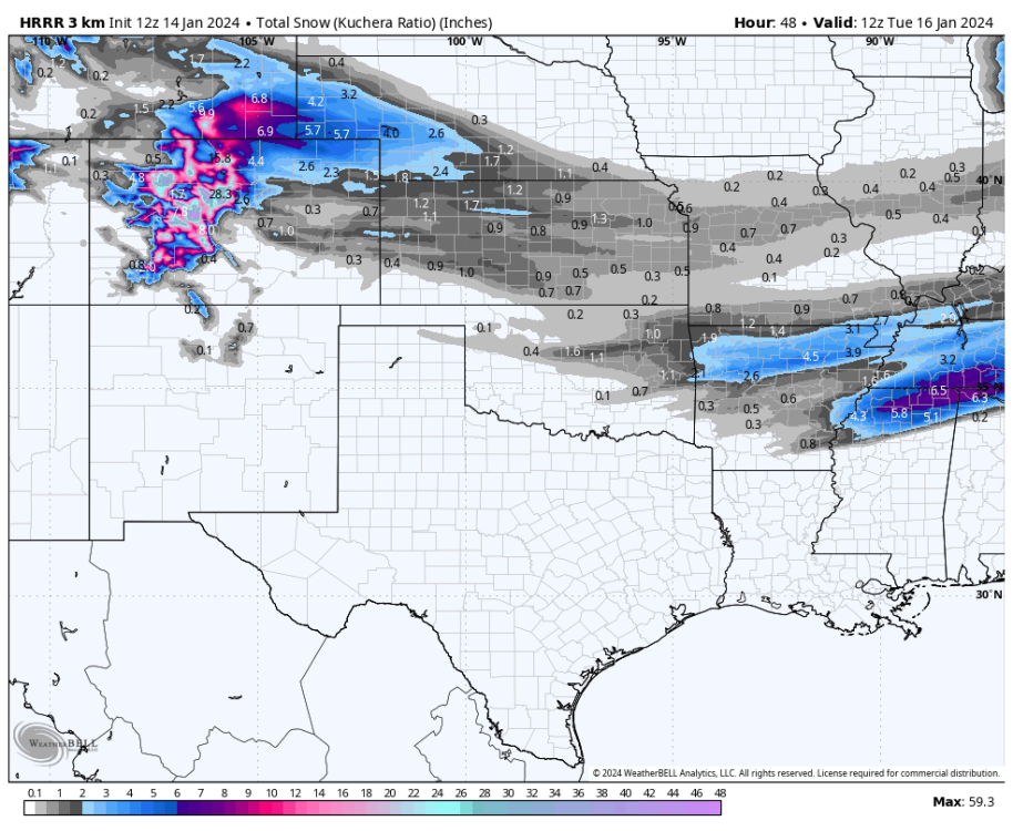
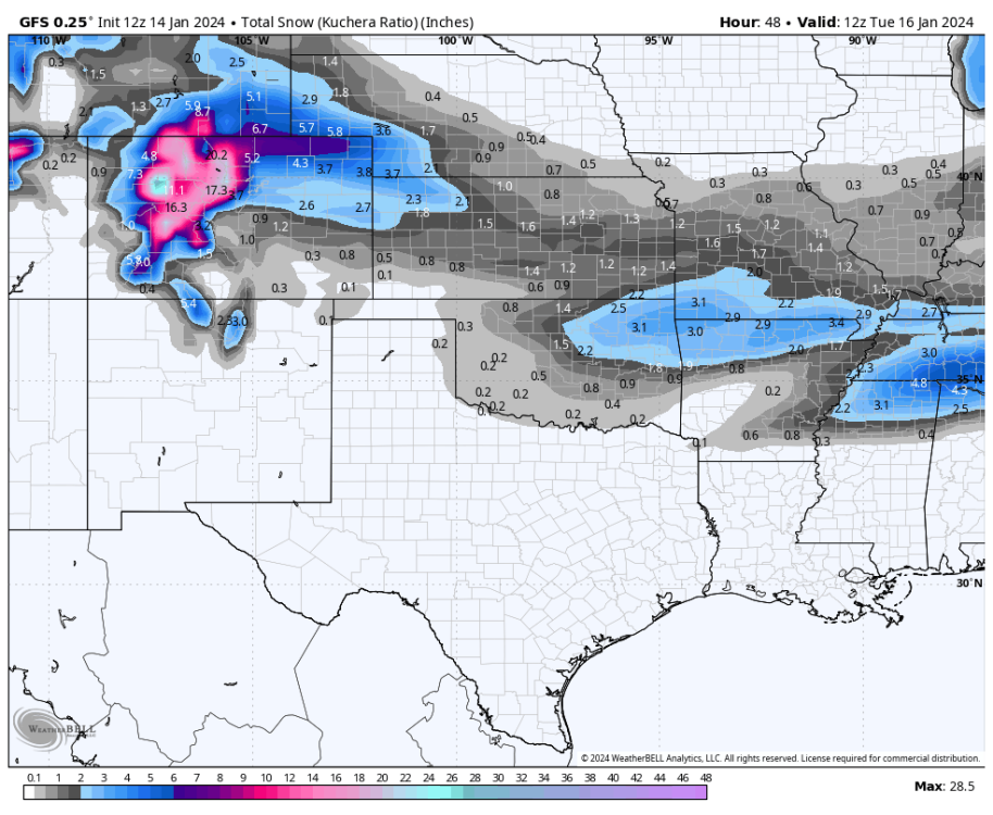
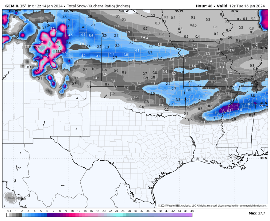
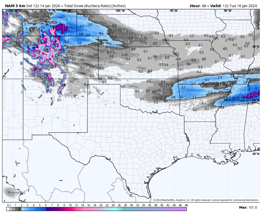
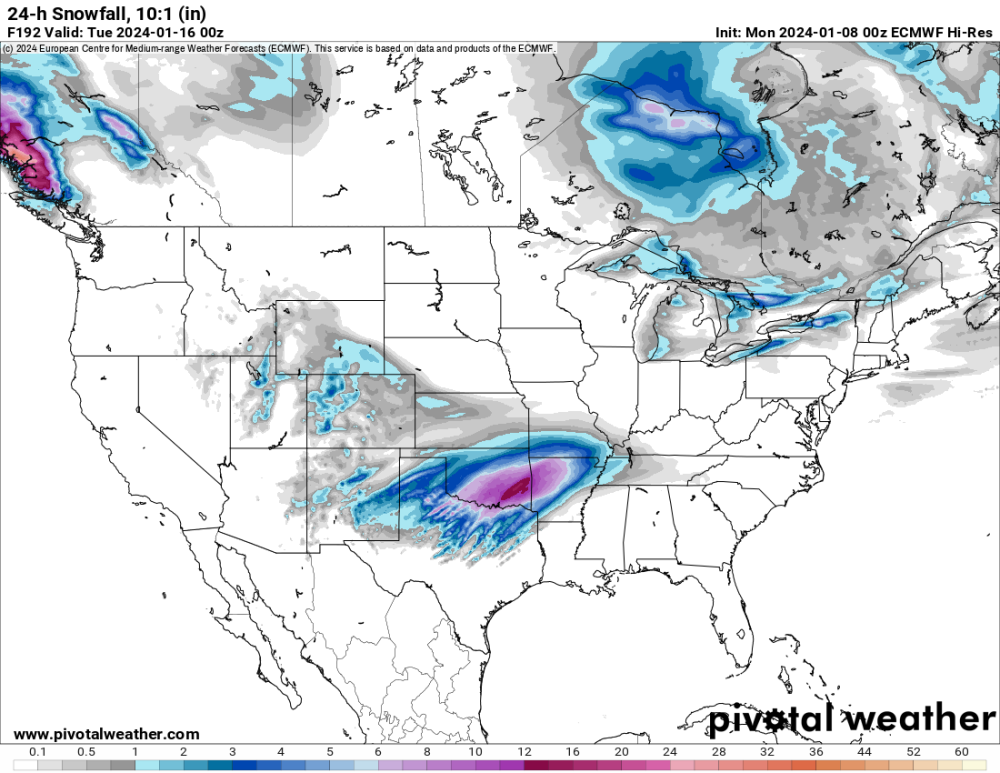
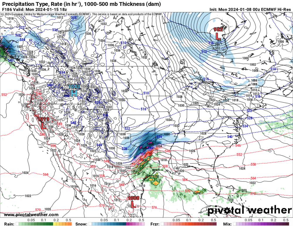
January 14-16 Major Winter Storm and Arctic Blast
in East of the Rockies
Posted
Our forecasters also did an excellent job, in my opinion, given the changes and spread sometimes going into the last 48 hours of the forecast period leading up to the start.