


OKwx2k4
-
Posts
5472 -
Joined
-
Last visited
-
Days Won
33
Posts posted by OKwx2k4
-
-
One truly unique thing this month is that there are an unusually high number of trees which have broken out in bright yellow splotches.
Definitely very likely heat stress and surface drought-related from end of summer, but I haven't saw trees change this early in years. Probably 22-23 years. Can't remember which.
I'm split on whether or not the overall foliage season will be good or bad.
-
 3
3
-
-
1 hour ago, Iceresistance said:
Rain!
That's a nice good wall of water headed east on radar. Looking forward to it! Definitely an autumn feeling day today.
-
5
-
-
I'm sitting at a nice cool 60 degrees this morning.
Fall is officially here in green country. I couldn't be happier. Going to be a beautiful season.
-
4
-
 1
1
-
-
Glad to hear thunder and rainfall returning to my area tonight.
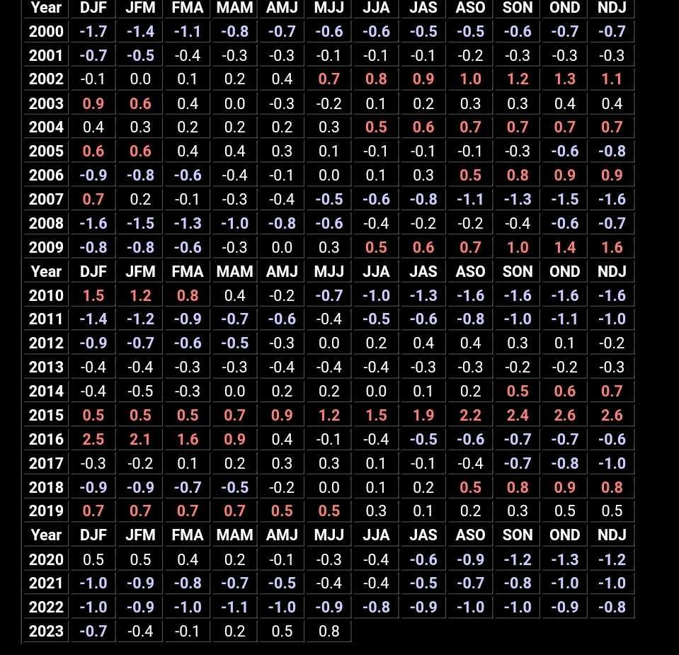
Doing some record searches for fun I discovered that September has an incredible temperature range at Fayetteville Arkansas.
The all-time high is 103 (tied on 3 other occasions), and the all-time low was 31. It has frosted three times in September since records began there in 1949.
Makes June, July and August the only 3 months here which have not recorded frost or freeze. I don't believe we will see that this year, but it is interesting.
Of the coldest Septembers on record, only 2009 at 15th place ever went on to produce a great winter. However of the memorable warmest and driest episodes in September history, 2000 being a prime example and 2013 as another, the winter that followed was epic.
-
1
-
-
My only disappointment with my forecasting so far since spring is underestimating the heat/drought cycle severity in TX coming off a Niña. A mistake I hope to not overlook in the future.
-
3
-
-
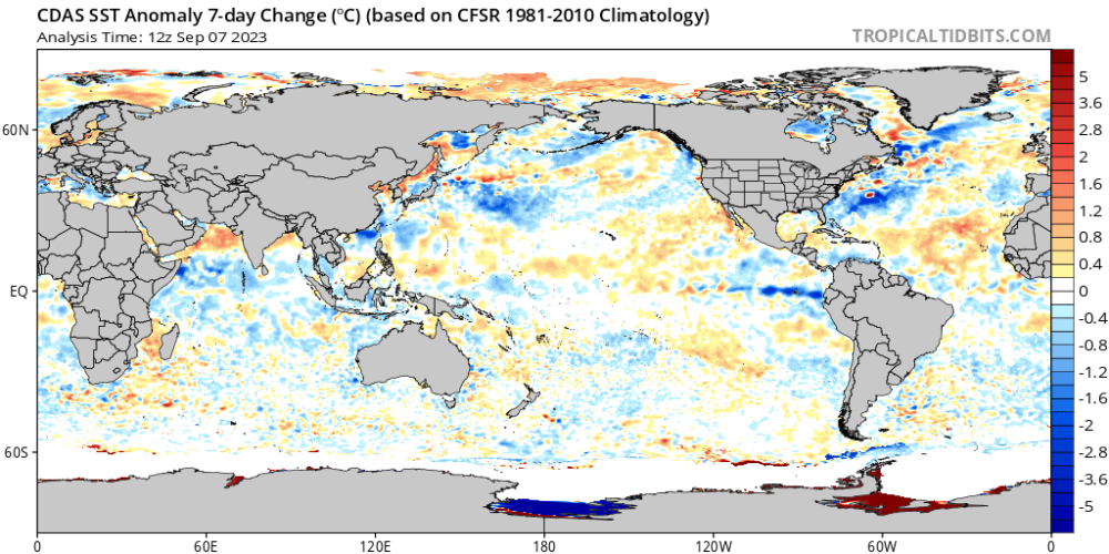
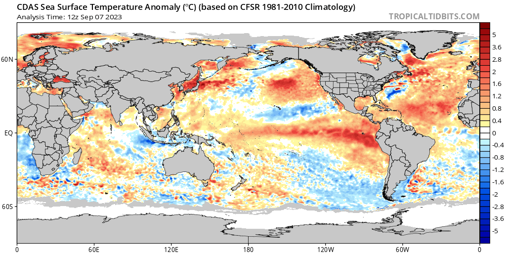
The change I've spoken about in the Niño has officially begun in earnest. It appears 1.2 has topped out and begun its gradual step-down process, while 3.4 is holding stable. (2009 Analog for the win.)
Also, seeing the cold strip from Hawaii to Baja warm is a huge indicator for cold over the CONUS and a positive pdo signal developing.
This should shift forcing back off towards the dateline and open the door for colder futures anywhere east of the Rockies with exception to the New England states.

-
5
-
-
On 9/5/2023 at 7:53 AM, Black Hole said:
I'd be curious to hear more about what you are looking at for the southern hemisphere flipping. I wasn't even aware they had been running cold for so long. Interesting stuff.
It's not made public knowledge very often because its not really popular (like the growing mid-latitude glaciers, etc), but, yeah. Up until recent years (record max 2014; 2 seasons off the Arctic's record low) the ice in the SO. Hemisphere has grown steadily for 40 years.
It's like so many other climate scare holes in the science they don't have answers for and never predicted.
This season they recorded a record ice loss, while over the last 10 years ice loss in the Arctic has stabilised and our Hemisphere is nowhere near a chance of recording a 40 year record low at minimum.
Here's an article from 2019 that talks on it a bit.
-
 1
1
-
-
On 9/5/2023 at 6:01 AM, Tom said:
Something is telling me this will be a "Frozen Tundra" come JAN...enjoy the warmth as much as you can and prep for an early Autumn (heck, you can say it has already come up by you).
Meantime, our friends wayyy down south should really like what the models are showing. Is this the trough that "breaks the Summer back?" I am becoming increasingly convinced ya'll down south are going to come out of Summers grip with a nice Flip. @Andie @OKwx2k4 @Black Hole and the Okie crew.
....just for fun, not a forecast, but some early signs of the new LRC??? Kinda looks like many of the maps @Black Holeand others have posted in our threads. That is a classic El Nino #STJ pattern...I'm going to try and dial in on the up pattern ahead as we get towards the middle of the month and provide some clues of the new LRC. This is about the time of year I start paying attn to Eurasia and the snow that begins to fall up in the northern lats among other variables at play. My gut feeling is this will be an overall active and exciting season tracking storms.

There's stuff setting up right now that looks almost too good to be true if you love real winter and cold weather.
-
1
-
-
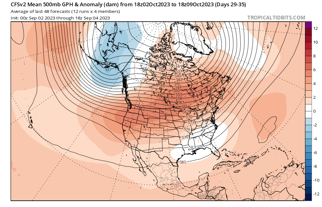
GFS showing a nice trough cutting right down the heart of the country mid-month. Going to feel like a whole other world to a lot of us after the summer we have had.
-
5
-
-
10 hours ago, Black Hole said:
Definitely think its unlikely we go the super nino route. Besides the different modeled progression, the pattern this summer has felt distinctly different from those years. That also showed up in the pattern analog years I posted where my number one match was 09/10.
In that article you shared the UKMET wasn't so good, but it was nice to see the above normal snowfall every month on the ECMWF. I'm curious how many inches it actually showed now

Yeah, the UKMET was absolutely a sad winter. About like looking at NMME or CFSV2. Lol.
I've never saw the Euro show above average snowfall here starting in November. I know outside of this warm cycle we are in, it snowed here November through April more often than not until the hemispheric climate shift in the late 70s.
That era will return. I have no doubts now after looking at the SO. Hemisphere temp alignments shifting. They've been cold for 40 years.
Flip time.
-
1
-
-
Just on the number of "once in a hundred years" events this year, sky's the limit on winter and I really mean that.
As @Black Hole mentioned, 2009 and 1976 are probably my top analogs as well. We're simply slightly later than 2009 in progression.
Add in 1980-81, 2000-01 and 2010-11 (Part anti-logs, part for exiting deep Niña and just actual verified weather) for background state and other variables around the globe, and you have every ingredient to produce long-lasting cold that is really hard to budge.
-
If the Euro depicted in this article verifies, going to be winter here in November.
It's showing above avg snowfall for every month Nov-Jan.
-
3
-
-
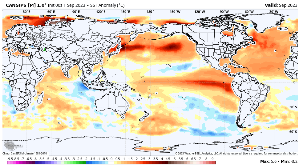
7 hours ago, Black Hole said:
We still need to wait 2 days to see the new seasonal ECMWF, but the CANSIPS still really shifts the big warm anomalies west over the next couple of months with a textbook modoki setup for much of winter. While nobody knows for sure, I still think this favors a cooler winter for many of us, especially JFM.
This right here. Beautiful. Been waiting on this. I'm good with being warm for a bit. I'm still betting on cold.
This is not a classic, canonical strong Niño. I just don't see it going the 1983 or 1997 route.
-
1
-
-
13 hours ago, Hoosier said:
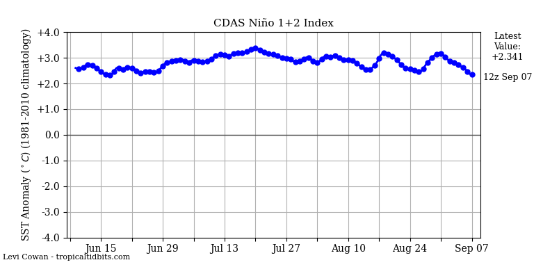
That chart you posted is the ONI chart, which does use region 3.4 for the measurements. So looks like we're all good.
Most people would classify anything above 1.5C a strong Nino. Based on the trends and modeling, I don't think we're going to be able to keep that number below 1.5
We'll see. I don't think it has a lot of strengthening to do as an east-based. I think we'll see 1.2 start collapsing any day now. I think it'll yield a moderate Modoki by time all is said and done. Some folks use SOI or another way of measuring 3.4, which is why I stated that.
Like 2009, some call it moderate, others call it strong. Technically, it was strong by number for only one month.
-
4 hours ago, Hoosier said:
I don't think there's a prayer that this Nino ends up as only moderate based on ONI. Now the bigger questions, assuming a strong Nino, are does it act more like a moderate Nino, how is the forcing distributed, how quickly does it start to fade, etc.
I still use the original standard as measured in 3.4. Keeps things consistent. To each their own I guess.
If ONI has a strong Niño, I wouldn't know it.
-
If our Niño can flatline, it appears to have a shot at being classed as moderate, which is a great thing.
For those who may not know, even if 1.2 is over +3°C, if 3.4 is +1.12°c it's that number we measure by.
Still giving me cause to toss the extreme Niño analogs.
-
1
-
-
2 hours ago, CentralNebWeather said:
NWS Hastings says well above normal, record temps?, starting Thursday and lasting through at least September 11th or longer. They mentioned it may be the longest late season heat wave that they can remember. Not a fan of this.
Yeah. It appears that it will actually be hotter there again than down here. I think the 2011 heatwave was more confined to the south.
-
The funny question is why theirs doesn't match Tidbits CFS monthlies. Is there something I'm missing?
-
4 hours ago, Black Hole said:
Pretty interesting seeing how closely the CFS run last night matched the analog progression I posted.


Spot on. Absolutely spot on. Nothing to add to that.
-
1
-
-
6 minutes ago, Tom said:
I do see the DP's will be lower and more tolerable which will make it "feel" more tolerable. You gotta look at the bright side of things!
I agree with that down here too. 100 with a dewpoint of 80 feels far different that 96 with a dp of 60.
The pattern is changing, just not always "here" yet.
-
5
-
-
60/90 looking like my numbers each day to close August. Looking like normal end to summer with at least one more heatwave in store for the majority of us.
-
2
-
-
3 hours ago, Andie said:
81 with that front. Awesome.
Smells like rain. Awesome.
I’ll take that big Low crawling into Texas! Let’s hope it makes into a Okla as well !I'd take it. Ground will be pretty dry by then.
-
1
-
-
6 hours ago, Black Hole said:
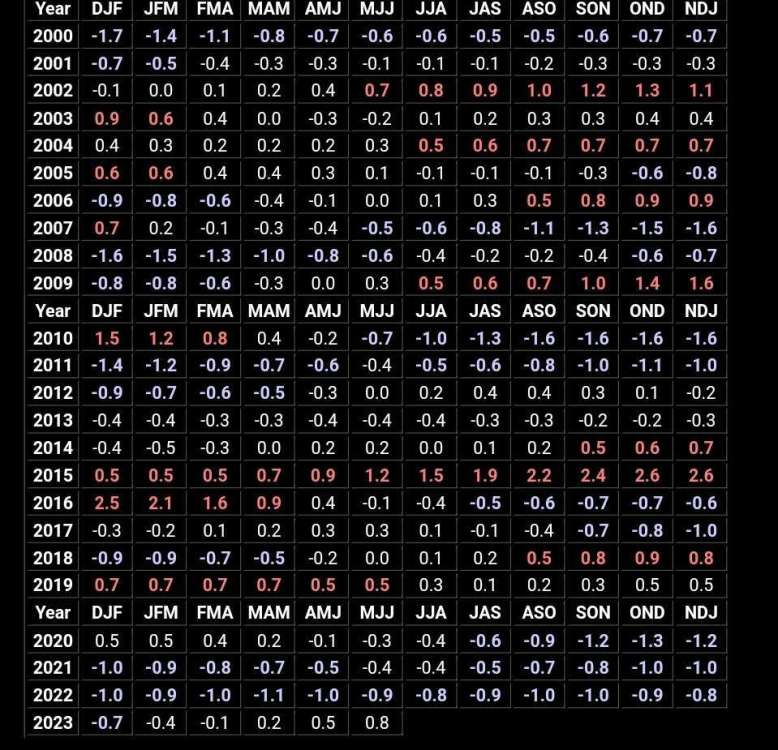
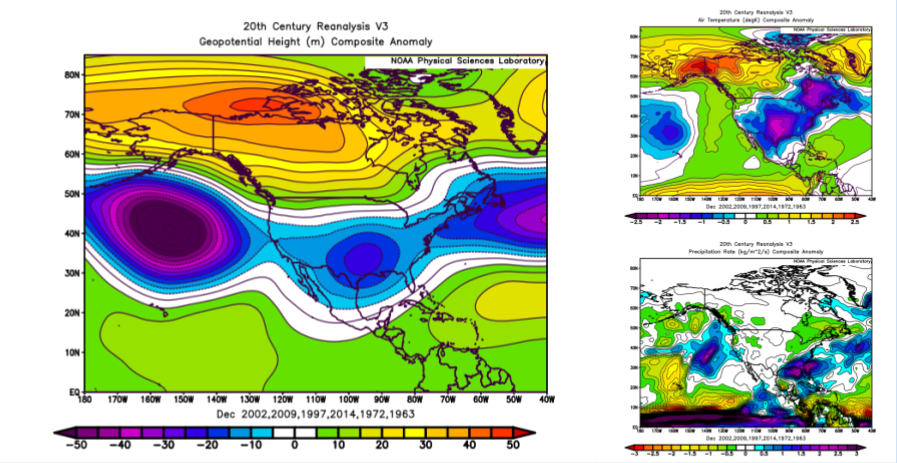
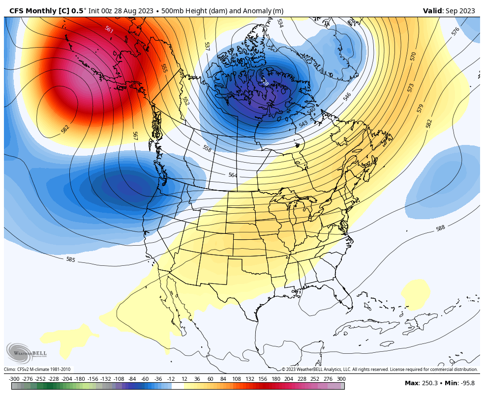
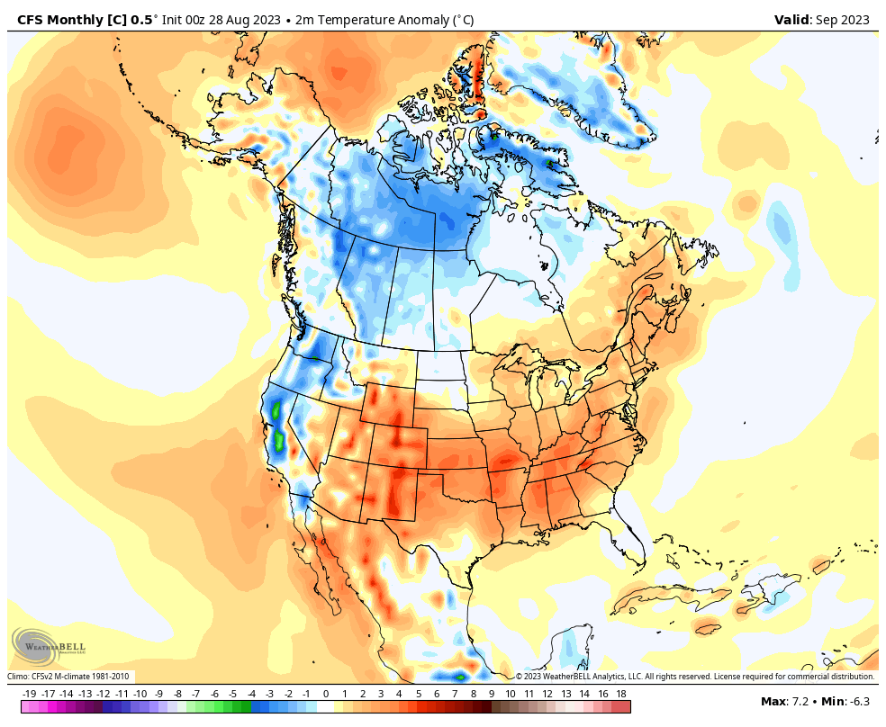
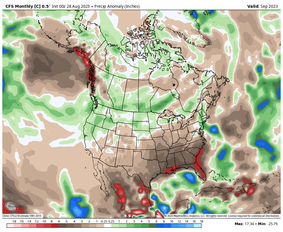
I spent some time this morning matching the forecasted pattern for the 1st half of September (with some nod to towards the EPS weeklies for the 2nd half) to try to get our current top El Nino analogues. Here is what I came up with and the analog forecast going through fall and winter.
September:
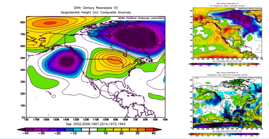
October:
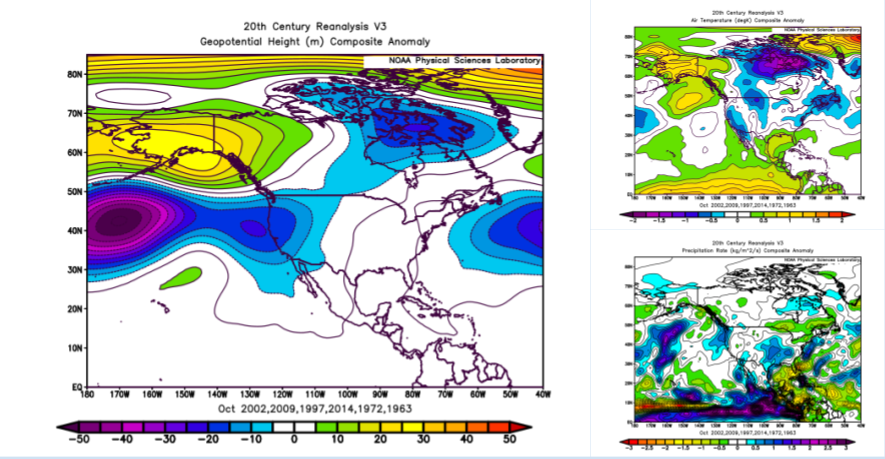
November:
December:
Jan-Feb:
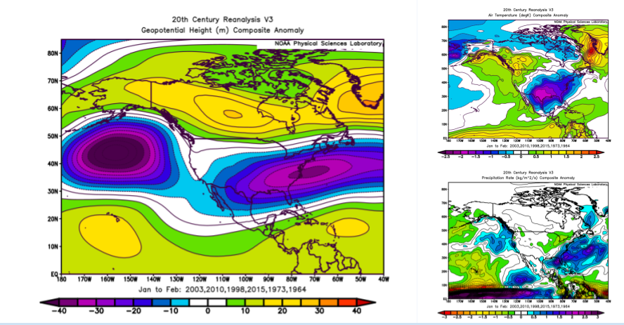
So if this progression is right, September will be the last warm month for all of us, with October being a transition month, and then cold for the rest of the winter. This would no doubt be a very wet winter towards Florida, and near to below normal for the rest of us. However, its good for snow in the south. Probably a cool and dryish winter in the north.
The analog matching didn't have any great matches, but the composite of the ok matches actually turned out pretty well. I guess we will see what happens.That's a really cold winter and the perfect progression.
Sometimes analogs don't exactly match month-to-month I have found, but the patterns and progressions work correctly. You just slide a month forward or backward.
I've had the "opposite years" thing as well and believe that's due to coming from an overwhelmingly long Niña. When I'm seeing 2000, 2008, 2010 show up, it's weird. Lol.
-
If the latest 12z runs of the GFS are to be believed, in 10-11 days Andie will be the closest of us all who are under the heat dome to average temperatures.
In the meantime I'm going to enjoy the cooldowns. It feels great after oppressive heat to even go back to average, let alone below average for a few.
-
3
-


September 2023 Observations and Discussion
in East of the Rockies
Posted
Next 100 or so hours around my region look like autumn perfection followed by a late reminder of our summer before I believe this pattern finally starts to cave all the way.
It'll put September basically on the lukewarm side of average if it all plays out. Will have at least a better base of data to look at in the next few days. Glad to see a cold front deliver all the way south of the Red River.