


OKwx2k4
-
Posts
5470 -
Joined
-
Last visited
-
Days Won
33
Everything posted by OKwx2k4
-
I'm beginning to think we may all grow gills to breathe at this point. I've literally been physically looking at the GOM in my life and never felt a dewpoint like the other day without fog. In fact, the number of times I remember seeing dew at these extreme night low temps in my life is very few in August.
-
Then emee are actually in very much perfect agreement on all the other contributing factors. I was unsure about the expected effect on the stratosphere or other layers and how it would relate to the surface. I'm still learning a lot about how vertical mixing all the way throughout and how it affects longer-term cycles. Not necessarily overall climate. You're right in that the ultra warm Gulf early in the season was a big part and absent tropical storms to aid in mass heat transport from equator to pole, massive death ridge was the only out. Same with the high lat ridge over western Canada, I'd assume. When the tropics are suppressed that long, it has to go somewhere. If the Pacific can finish shuffling all its major weather features around quickly enough, it'll be the polar opposite around here in short-order. I find it unusual that all the records we are contending with every day from now to September 7th or so are mostly 2000 (Mod/Strong Niña), 2010 (HUGE La Niña) or 2011 (super Niña lag year). It's why La Niña years keep coming up in my ideas. Even one of the big late-70s years that keeps showing up was a weak La Niña. Odd, but it's been on point for me so far.
-
Lol. I like your style. Haha. Thanks for sharing. So I had a question for you. What are your thoughts, if any on hunga tonga volcano and its effects on our current weather, or winter. It's my opinion that these events this summer can be ascribed to long-term Niña drought compounded by persistence or already favorable conditions. In other words, there was already a well known drought in place, it grew. It was pretty predictable by looking at a precip map. I guess I would just like an opinion outside of mine and all the vague writing on it that just gives no reason or science just says, "it's going to be warm, trust us."
-
I still think so too even though I've not said it much lately. It looks like to me it has already started. It's just not materialised yet, if that makes any sense. Also as I look at the Euro today, I actually do see this giant ridge briefly shift west and poke up into Canada, so I still do have a lot of hope for a pretty radical shift in September.
-
I agree very much with that, but it still "is what it is". In defense as well, is the fact that one just can't predict extremes like this at seasonal range. One may call out potential stuff that could lead to extremes or use analog years that have those extreme events but betting on a 100-1 or more shot at 3 months out is not sensible. There's not a person anywhere that I'm aware of who predicted a California hurricane at range nor the Atlantic pumping dry air all summer long until the absolutely worst part of it and now we're all in 80 degree dewpoints. A very wild summer is an understatement. If Niño forcing can shift west, my belief is leaning toward this ridge becoming a future part of the warm PDO signature that goes with Niño. Hoping it retrogrades out west soon.
-
Am glad to see at least a positive trend starting. Hoping it continues.
-
Yeah. It got this heatwave correct. It's brutal. Very. Anything to break this heat will be welcomed.
-
Its going to be brutal down here, but I promise they are seeing it at the most beautiful I've seen it here in 2 decades. Hope they enjoy their visit.
-
The year without a summer held up poorly unless you consider this the compromise part. The northern parts have had the coolest summer in a long time, while the SW regions until recently have verified well. The ridge complex ultimately setup right from San Antonio to Arizona and extended north into my state and beyond ( Dust Bowl region), setting records as it went, so I'd rate that as pretty accurate. Thankfully at peak drought, a lot of folks saw great rainfall and even some major recovery in some areas due to what I believed to be a great inland store of water out of Colorado and points NW receiving abundance of water in the winter and spring. I guess the blown part of my forecast is this week, really. Never imagined the ridge resetting up over the heartland for the finale of summer and I'm truly disappointed about that.
-
Beautiful and ugly atmosphere.... Here's to reversals.
-
This right here. Perfectly said.
-
Pretty classic Niño look there.
-
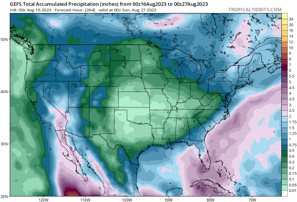
Up ahead, we have a giant donut hole of dry forming over many of us. Will be grateful to be on the tail end of a few more frontal passages if all works out. Otherwise, buckle up. The models do appear to change a lot day-to-day right now, so we may see something totally different in 3 days in the extended. Hoping so.
-
Yeah. A lot of times, evidence supports that early starts don't necessarily translate to more snow or winter events overall in El Niño. Exceptions being 2009 and 1976. In 1998s Niño, the Pacific raged and flooded the US with heat (same in 2016), but after Niño faded in spring, it was colder than average. In other words, when Niño faded in 1.2 and shifted forcing west, we cooled down. The reason I'm fine with the delay is that it appears to be well-timed. Let the Arctic and northern landmasses fill with cold first before we go dislodging too much of it and we'll see really good winter.
-
That's plain nasty heat. Yuck, indeed.
-
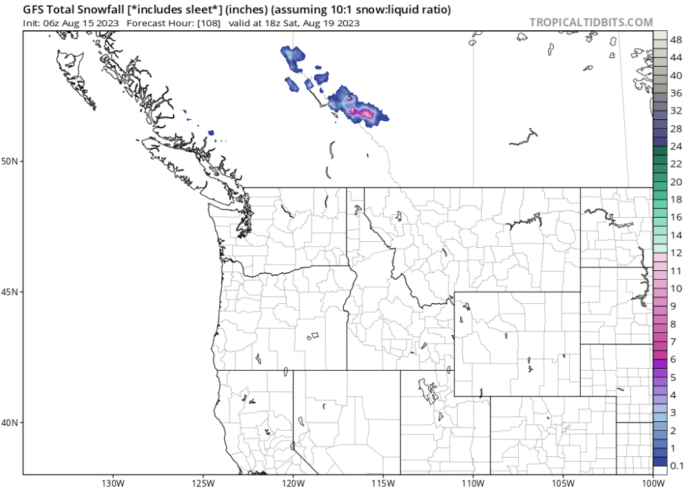
Well, the western part of Canada waa shattering all-time heat records 6 or so weeks ago, while Colorado was still seeing snow modeled in July, so I have faith in major reversals on the way still. Getting water out over So Cal and the desert SW is a blessing to me here in Oklahoma as well, as it seeds moisture into storms. Monsoon is usually a June event, as is the opener to Gulf hurricane season along TX/LA and here we are still waiting on a major hurricane. If it all flips at the same time, we're all going to have a lot of weather to yalk about. Anyway.... Western Canada. From shattering all-time records to this..... Think cool thoughts, my friends.
-
Going to be a tough stretch across my region to close the month out here in the south. Especially in Andie's area. In contrast, wild to see our northern states see one of their coolest summers in history. If the Niño continues its decline as we go throughout the rest of the month, we may see a change shortly after month's close. Hoping the tropics truly do wake up soon. All the moisture is returning off our southern and eastern coasts. Hoping this relates/propagates into moisture return when the heatwave breaks.
-
Anybody else having trouble getting reactions to work on the site? I don't mind, as it encourages communication, but I enjoy liking everyone's stuff even when I have nothing to say.
-
I'm glad to see the cool front is going go at least cut the heat down for a couple of days there at least. I didn't make that call because it was hard to judge where the front would stall. I saw comment about hurricanes as well and I agree that this pattern usually ends with a hurricane, but we still have some retrogression of this ridge to go. The tropics are really out of whack now.
-
Same here. I can't believe it. It's going to be refreshing here in the morning. August is a month of extremes for us. We rarely notice that huge range we can get in just a two week span like we have this year.
-
While I do want to shift as fast as possible for personal reasons, the delay will be worth it if we love winter. @TomGreat write-up. It does show a perfect, albeit slow change into what looks like an amazing autumn. Seeing a hurricane run the Baja peninsula in model-land is a huge tell as well. I love how by November it now has Niño moving west. That's critical as well.
-
Yeah. There's been some wild weather. Great rainfall, too though.
-
Right. It's the absolutely most perfect pattern.
-
Buddy, that's cold weather. Extremely cold. Like you said, exactly the opposite. Imagining that on into full winter months of DJF and you have a full-scale memorable winter for the whole eastern 2/3 of the US.
-
Waking up under what looks like an atmospheric river today. After all the heat, it's very welcomed. Was very nearing drought category or was at it again. Had grass dying or looking burned up. Really feels like summer is ending early, though. As the models continue their waffling back and forth, will be interesting to see if the severe heat clears out all the way back down through Texas before month's end. August is a weird weather month sometimes. Anyway, thankful for the rainfall.


