


OKwx2k4
-
Posts
5470 -
Joined
-
Last visited
-
Days Won
33
Everything posted by OKwx2k4
-
That's beautiful.
-
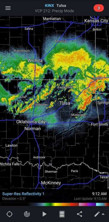
I'm so glad models whiffed on this one. Radar looking pretty nice.
-
That's a pretty solid assessment. One more week in the furnace. We got this. I've got tomorrow at the peak before it comes down VERY slowly for me.
-
Basically, my belief is that the excess evaporation and snowmelt seeded storms over the central US. It was like having a reservoir of water inland.
-
The lengthy dry spells are a byproduct of being in LA Niña for the last 3 years. Less heat to atmosphere in general means less water vapor transport to us. I believe if Colorado hadn't had its wettest period on record going into this warm season, northern/central parts of our region would be desperately struggling right now with very little help from the cold waters in the eastern Pacific (off Cali and the SW US) blocking the Niño input. Our Summer in a lot of places would be a lot different today.
-
If the forum wants to watch the perfect pattern to cool our continent, there it is. I just am scared we'll see it too early. Need that 1.2 Niño region to collapse along with this silly ridge to retrograde.
-
Man, if you take 2019 and 2006 away, wow. Tom wrote on the rest of it well. I don't really mind there being a ridge occasionally over the Aleutians in Autumn, (per this map) but the fears come if by October, that thing doesn't budge. Thankfully, the SST alignment doesn't truly, in my opinion, support massive ridging into DJF.
-
Today through the next 84 hours or so begins the slow breakdown of the frustrating heat ridge over TX and OK. At least the opening salvo in a clash of cold and warm that will probably become a hallmarker of our early autumn pattern as the month progresses. Most iterations in model-land actually are leaning towards pooling up cool air in the heart of the nation. This is a great resemblance to 2009, just a month late. In 2009, the arctic had already teleconnected -AO and combined with tropical influences to begin fall early. The pattern shift happened in July instead of August. Niño hauled it from the east flank (1.2) out to 180 degrees (3.4) and parked it. The rest, as they say, is history. One thing that is surprising me today is that there aren't a lot of typhoon recurve situations over the Pacific to punch up the wave train in the polar jet yet and I'd have thought that would be well started by now with El Niño having rule over the bulk of the weather pattern for the time being. If the western part of the warm pool can continue splitting and retrograding west, typhoons will recurve and punch the PV. I think the southern ridge is crying its demise as we speak. My region of Oklahoma enjoys a pretty huge range of weather in August. I don't know the dates or exact records off hand, I know we have saw temperatures ranging from 110 degrees to as low as 50 (maybe unofficially some 40s in valleys or near cold springs), which is pretty astounding for a warm month in the south. As we go on through August, I make it through the dog days by looking where the seasons are starting to change on our continent. When I see central-eastern Alaska and western Canada warm with our west coast heating up also, I know good things are coming sooner rather than later for the eastern 2/3 of the country if you're ready to cool off.
-
As a general guess, the strongest Modoki was 2009 and it peaked at moderate. Don't know of any really strong events that didn't really bleed over into the full-latitude category. I used to know where the reconstruction sst maps were and could be generated, but I don't anymore.
-
There's that westward shift in the Niño I've been looking for! Should be actually underway right now. Add all these things together and trim off the extreme solutions on either end of the spectrum and I think it spells a nice winter on the way. It's August 1, I can talk about winter now. I think we're all over summer finally.
-
Our month with only a couple of days to go. Borrowed from a Facebook post.
-
I feel like Michigan did back in spring. Lol.
-
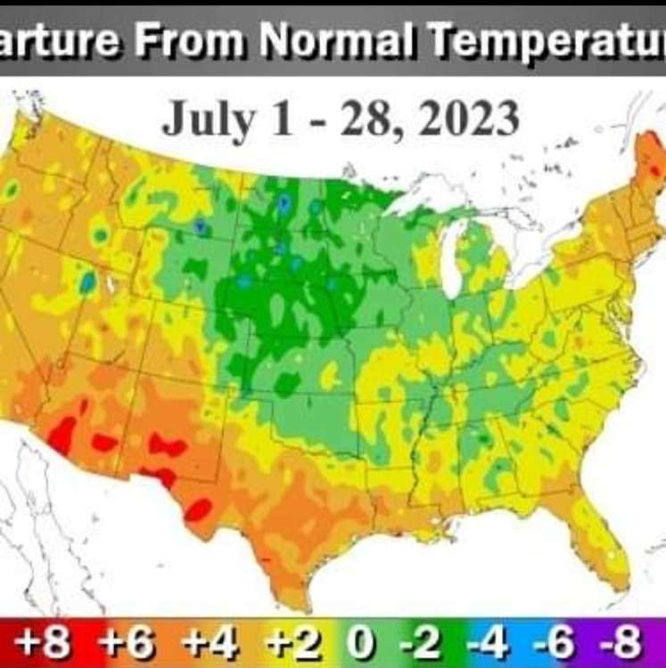
I don't disagree with that assessment at all. If we were breaking records at peak summer, it'd be extreme, however, due to humidity, the above avg and discomfort is at night. This has actually been an incredibly good summer in a lot of places.
-
Had some unscheduled showers show up this AM and now looking at models, although there's a heat dome, it appears showers want to break out periodically through the forecast. The bad news..... Looking like the bowels of hades on 8/4. Still time for these highs to come down in later runs, as has been the pattern of late. Still, that's hot stuff folks. We have crossed over peak summer as a nation and that is wonderful news!


-
Yeah. Looking at my forecast, it's 7 days of 95/70 temps and sunshine. Would be nice, but I work in it. Far better than some of the extreme modeled solutions we saw a few days ago.
-
There's no getting away from a good punch of heat for most of us in the subforum through the next 5-7 days. The top half or so of the forum appears to get cooled quickly after. Longer-range stuff is really showing split-signals. The annoying ridge causing all this appears to reset in the SW, while possibly retrograding further west, in some runs and ensembles. Some even stack ridging up the west coast all the way into the Arctic and Alaska. This would almost certainly put cooler readings east of the Rockies just after month's end and into August without any type of SE ridge present, really.
-
Absolutely. I'm looking forward to what should be a truly beautiful autumn. I don't really see a future of summer prolonging itself into late September, as has been normal the last few years. Warm-dry autumn is more of a Niña type feature, although not a guarantee. If we get a huge cool week in the middle of next month, it'll ring more of those 2009 memory bells. That year was perfect. White Christmas, snow in every month. I'm truly glad we have good and smart folks like you in our NWS here in Oklahoma. You have one of the most difficult or challenging meteorology jobs of most offices in the country. It's not something I take for granted. The July cooldown at the end of 2009 did produce the coldest July day I remember. According to mesonet, 7/30/2009 had a high of 76 and a low of 66, still making it the coldest I can remember. (Besting even the record from 1915 that was recently reset). What's compelling is that it came 2 weeks after a string of 97-100 degree weather over 5-6 days. Month had a temp spread of 100/53. It had something for everyone. Lol.
-
Yes! Absolutely. You nailed it. I've seen it every time. In fact, it's very well noticed in the fact that I'm sub-20 on 90 degree days. Does that mean it's not been hot? Nope. BUT, lasting heat anywhere but west and SW of us? No. Not even close to what we see forecast a lot of times. If I looked at modeled heat anomalies on maps in forecast vs actual results. It's night and day to me. If we only remembered anomaly forecast maps, we could easily be deceived to think this summer has been horrifyingly hot all over. Not true at all, as the actual temps proved out. Also, very correct on the 2009 look. The pattern gets to where it really looks like a massive "death dome" may setup like in the mid-and late 90s or a couple of the early 2ks years and then "slam", a trough busts it all up. Yesterday was the coolest July day I can remember since 2009. Well, it was actually the coolest high for that day since 1915. I think it's compelling that three of us have independently said, "Hmmm...Something is off here." That and the 2009 flashes are so uncanny. If the 1.2 region of Niño collapses, we'll see more of that 2009 pattern. I can't blame forecasters when guidance is off, but they have a duty to make sure we are safe. Far cry from crying wolf. Extreme heat and cold without warning are both deadly, so I get caution. Especially with more and more people in our time today, it seems, who are intolerant to extremes of temperature do to lack of acclimation or activity in some situations. I guess what I'm saying is that you folks have had your hands full this year.
-
They're showing the autumn I've forecast, basically. That ridge over TX has a home SW and the Northern part becomes an NAO block in my scenarios. This is the setup to our winter. A lot of mets forecast Niño based off only one of them... 1998. There's so much more to it than "California floods and the weather is extreme. Push how warm it is." That's the Niño agenda. It's a stock forecast, basically. I guess what I'm saying here is El Niño is neither a blanket statement nor an excuse. Lol. That SW ridge now has a tropical pacific connection forming as waters increase dramatically in temperature over and near Baja the last few weeks. Cold air typically over time pools up over the continents in our current ocean alignment. With the warm pool setting up in the NE Pac, the theory here is that the EPO/AO/NAO drive the bus while the Niño starts to fade out and just subtly feeds moisture into storms. That's the scenario I envision as these heatwave episodes break down.
-
That's awesome. I had about half what you picked up.
-
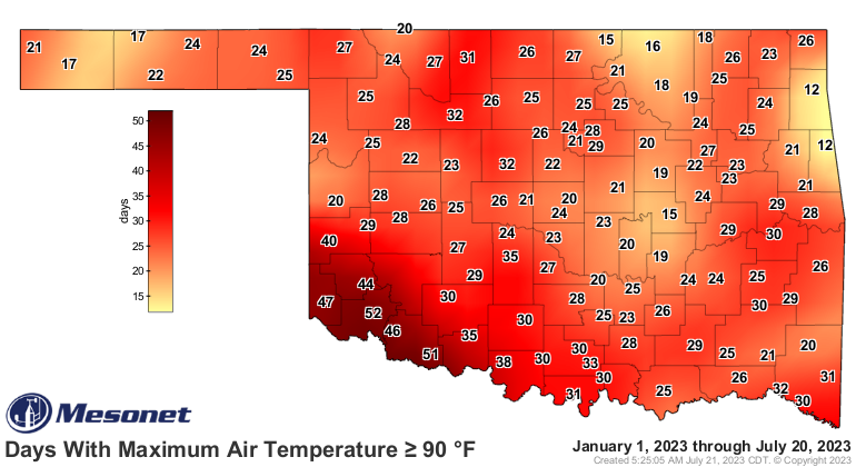
To say that I have been spoiled in relation to the rest of my state so far this summer is a massive understatement. Tied for fewest 90 degree highs is a great place to be. Blessed. Very much.
-
My high 0f 79 for today was actually reached at midnight. Only forecast to reach 77 by afternoon. I can probably count on one hand the number of times that's happened in mid-late July. I'm going to enjoy this next two days before going right back in the furnace Monday.
-
True, I suppose. There's a literal barrage of rain and cool weather headed in tonight through tomorrow. Will be a relief.
-
Days like today make me want to tell forecasters that heat index and real temps are not the same. It doesn't matter what it feels like, 93 isn't 99. That's a blown forecast by a mile.
-
I envy your July weather.


