


Nov1985
-
Posts
614 -
Joined
-
Last visited
Everything posted by Nov1985
-
PNW December 2022, winter might be coming; but mostly canceled.
Nov1985 replied to The Blob's topic in West of the Rockies
It will happen again. But I think ECMWF/EPS will pick it up before the event start is 130 hours out. Also, big difference of 3 feet of snow in downtown Seattle (GFS forecast) vs at 600' in the snowy spots of Kitsap co. -
PNW December 2022, winter might be coming; but mostly canceled.
Nov1985 replied to The Blob's topic in West of the Rockies
More likely than the 00z GFS, the very dry air will be crippling if you don't have enough hand lotion. -
PNW December 2022, winter might be coming; but mostly canceled.
Nov1985 replied to The Blob's topic in West of the Rockies
It's going to feel cold Sunday to Wednesday, but I don't think we have to worry about "too much" snow. Certainly not roof-collapsing amounts of snow with this setup. -
PNW December 2022, winter might be coming; but mostly canceled.
Nov1985 replied to The Blob's topic in West of the Rockies
Euro already threw them a bone and EPS has been consistent. We won't see 40" of snow in Seattle, and Spokane won't smash its low temp record. But a nice round of moderate cold and snow will sink well into Oregon. It's all right there in ECMWF and EPS runs for 3 days now... -
PNW December 2022, winter might be coming; but mostly canceled.
Nov1985 replied to The Blob's topic in West of the Rockies
Ya, but snow depth in that run peaks at only 24.7" for Seattle. Lame.... -
PNW December 2022, winter might be coming; but mostly canceled.
Nov1985 replied to The Blob's topic in West of the Rockies
Maybe after Wednesday or so. But EC/EPS has a decent probability track record for the Sat/Sun event timeframe. -
PNW December 2022, winter might be coming; but mostly canceled.
Nov1985 replied to The Blob's topic in West of the Rockies
Pay no attention to GFS. It means literally nothing this week. -
PNW December 2022, winter might be coming; but mostly canceled.
Nov1985 replied to The Blob's topic in West of the Rockies
Just ignore GFS entirely. Mr. consistency runs in less than 2 hours. -
PNW December 2022, winter might be coming; but mostly canceled.
Nov1985 replied to The Blob's topic in West of the Rockies
Random musings...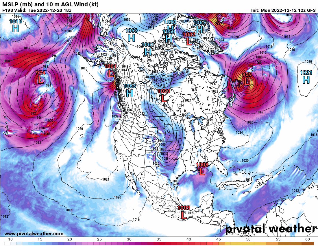

-
PNW December 2022, winter might be coming; but mostly canceled.
Nov1985 replied to The Blob's topic in West of the Rockies
I swear I read this comment and map yesterday. -
PNW December 2022, winter might be coming; but mostly canceled.
Nov1985 replied to The Blob's topic in West of the Rockies
NAM actually forecast that narrow pscz band. First spotted by Skunk Bay weather as scary clouds then it quickly aligned and dumped for a few hours right on the King Sno line. Power went out quick. Heaviest snow I ever shoveled.
-
PNW December 2022, winter might be coming; but mostly canceled.
Nov1985 replied to The Blob's topic in West of the Rockies
The trees, branches, cracking and crashing. It was terror. Lost a few tree tops too. Structure repairs and cleanup cost $$$. But I'd do it again. -
PNW December 2022, winter might be coming; but mostly canceled.
Nov1985 replied to The Blob's topic in West of the Rockies
Just a few miles N and E of Seattle was 11 inches heavy snow. The tree damage from that one was significant. There was wind after too.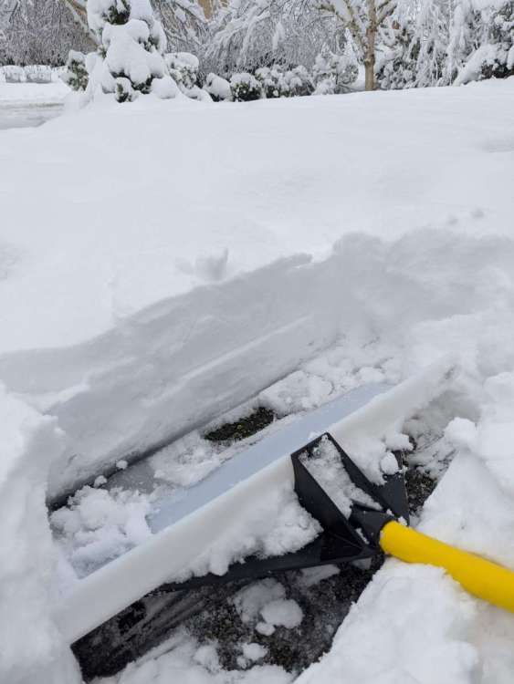
-
PNW December 2022, winter might be coming; but mostly canceled.
Nov1985 replied to The Blob's topic in West of the Rockies
Agree on the forecast maps changing. I see some risks too, but I thought that nudge west of the high pressure between 00z and 12z actually looked pretty good. I didn't notice the staying north part..thumb.png.a932c09e57cb0f417690e9fae8294b90.png)

-
PNW December 2022, winter might be coming; but mostly canceled.
Nov1985 replied to The Blob's topic in West of the Rockies
T-Minus 114 hours until that modified front passes over the San Juan islands! -
PNW December 2022, winter might be coming; but mostly canceled.
Nov1985 replied to The Blob's topic in West of the Rockies
12z EPS showed cold and snow into N. California. 18z EPS just doesn't go that far out. Aside from debunked GFS snow maps, what model is showing a border hugging event? -
PNW December 2022, winter might be coming; but mostly canceled.
Nov1985 replied to The Blob's topic in West of the Rockies
M vs C 18z/12z

-
PNW December 2022, winter might be coming; but mostly canceled.
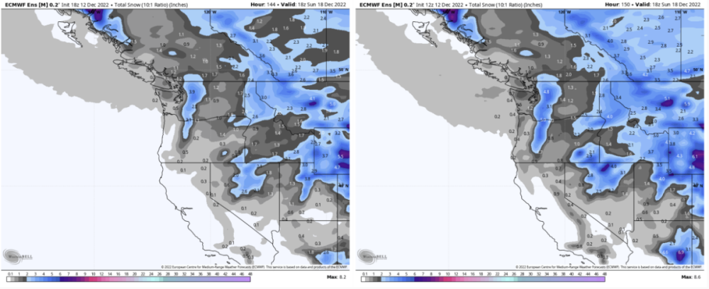
Nov1985 replied to The Blob's topic in West of the Rockies
Cold air still moving south when EPS hits the 144 hr limit. Maybe a bit slower. M vs C 18z / 12z snowfall with the front.
-
PNW December 2022, winter might be coming; but mostly canceled.
Nov1985 replied to The Blob's topic in West of the Rockies
Above was Control. Here is Mean..thumb.png.035e5e1ef4f78d860bd033a7819d0f00.png)
.thumb.png.34c059e86ae7cfc56530c2599ba9684a.png)
-
PNW December 2022, winter might be coming; but mostly canceled.
Nov1985 replied to The Blob's topic in West of the Rockies
A little less aggressive..thumb.png.7224855a4e3d4a7fe8caca6ec6f06225.png)
.thumb.png.efd2c2dd9eee6f14feabc073d2185c71.png)
-
PNW December 2022, winter might be coming; but mostly canceled.
Nov1985 replied to The Blob's topic in West of the Rockies
EPS tiny bits of adjustment. 12z / 18z.thumb.png.b7988efa39d04dcfeb11077d86e212ac.png)

-
PNW December 2022, winter might be coming; but mostly canceled.
Nov1985 replied to The Blob's topic in West of the Rockies
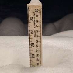
Speaking of low level cold, the last time I broke 42°F was November 26! Snowfalls of 8.5" and 3.5" so far this season. 4th fun winter in a row IMBY.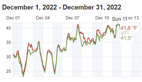
-
PNW December 2022, winter might be coming; but mostly canceled.
Nov1985 replied to The Blob's topic in West of the Rockies
I think this event has been advertised as a quick hit since the start about a week ago (6-10/8-14, EPS and other forecasts). Only thing that's changed is it is trending about 1.5 days earlier for start, while the ending/warmup hasn't really changed much. -
PNW December 2022, winter might be coming; but mostly canceled.
Nov1985 replied to The Blob's topic in West of the Rockies
This season I have enjoyed watching Russel Wilson suffer more than watching the Seahawks succeed. I may need to seek counseling. -
PNW December 2022, winter might be coming; but mostly canceled.
Nov1985 replied to The Blob's topic in West of the Rockies
Pretty sure December is still a ratings month for old school radio and TV media formats. So I'm sure they are drawing up the graphics today!


.png.7ab57107aed188a6a2e3a74ca98b88ff.png)


.png.02de8888f016e954f06d2e3c55650c60.png)
.png.f71a854650a84d47f6ff810e0be6ac15.png)
.png.abcd0ea6512389f1955f1d885428d0c6.png)
.png.5252f68413dc50575951052fdf24ceeb.png)
.png.975fe866d5c86bb7feff072798401b58.png)

