


AquariusRadar
-
Posts
303 -
Joined
-
Last visited
-
Days Won
1
Everything posted by AquariusRadar
-
The light snow flurries in the Sierras looks to be supplied with a backdoor moisture flow into the low that is over the center of the state. That moisture flow originates from the big blob of moisture near 145 W of the ITCZ. Isn't that path unusual. Or is that a sign of a potent summer monsoon coming for the Southwest?
- 4890 replies
-
- 1
-

-
- california
- climate
- (and 1 more)
-
News today- California government has a USD $76 billion dollar surplus over and above the current budget. Why not use some of that to do something about new water sources for the state? California government often reminds me of a dying carp flopping in the desert dust just inches from the water's edge-but never capable of flopping the right way in order to save itself..
-
There is nothing more noble than a coastal redwood tree. Tree huggers, of which I am one, have general notions about weather, and rainfall in particular, that science doesn’t put at the top of weather discussions. Notable weather expert Dan Swain of Weather West never mentioned trees in his discussion of the California High pressure ridge that is blocking normal rainfall:Dan Swain discusses RRR https://agupubs.onlinelibrary.wiley.com/doi/full/10.1002/2015GL066628 The most notable tree hugger notion is that trees are principal in the water cycle. A more complete science discussion regarding the biotic pump theory and world weather can be found here:Tree process of water https://www.treehugger.com/process-of-using-water-by-trees-1343505#:~:text=Trees supply leaves with water because of a,is eventually dispersed and released from leaf stomata. and here: https://upliftconnect.com/amazon-controls-earths-climate/ Here is my take on trees and the California drought. In the upper reaches of the Sea of Cortez, the brilliant sun beats down upon the warm water. One might expect evaporation of the seawater and the high temperature of the air to initiate some kind of natural precipitation to cool the thirsty Baja to the west and Sonoran desert to the east. The desert heat comes right down to the waters edge. But no clouds ever form. The enclosed sea is not alone in this predicament. The Red Sea and many areas around he world that set directly adjacent to seas are desert. The air parcel containing the evaporated water is at the same temperature as the surrounding air. It is not buoyant. There is no natural mechanism for the development of CN rainclouds. The dry air of the highs of the descending Hadley cell dilute and desiccate the surface air that might hold any evaporated moisture. Opposed to that: The Tropical Amazonian rain forest is the initial source for the Pacific ITCZ moisture as the equatorial thunderstorms come off the western side of the South American Continent. It is this air borne moisture that starts and maintains the long chain of thunderstorm events that keep the far eastern Pacific part of the ITCZ very active and is the fuel for ignition of Pacific Hurricanes. The same can be said for the storms that come off the African coast and start the Atlantic hurricane. The same can be said of the cyclones that form from moisture that departs the Indonesian archipelago to savage the Indian subcontinent and East Africa. All three of these areas owe their rain making ability to land masses that heat quickly in the equatorial sunlight and thick tropical forests that transpire huge quantities of water into the air. The Amazon rain forest is the most active region of the ITCZ and is fueled by the almost continuous draw of wet Caribbean and Atlantic air into its region of low pressure. That combination builds thunderstorms that move with the equatorial easterly winds off of the continent and sustain the convergence zone over the water. Each day the chain of storms is reinforced as new storms move off the coast. The continuing storms create the low pressure over the ITCZ that pulls up some additional moisture in the thin layer of high humidity air that lies just above the ocean surface. Most of that moisture is remnant from the previous days ITCZ thunderstorm activity. But this day to day cycle can’t continue indefinitely. The further west along the ITCZ less and less moisture is available and the thunderstorm activity slows and completely disappears near West 160; depending on the vagaries of ENSO. Without the initial thunderstorm activity created by tropical rain forests, the ITCZ would not exist as we know it. Evaporation from the ocean surface alone is not capable of creating the CN cloud necessary for thunderstorm development. The seawater will not heat up as the land will. The exception to this is of course the hurricane because the cyclone low pressure covers such a huge area of hot sea surface moisture and becomes self sustaining as it moves northwest away from the ITCZ. Without the tropical rainforest of the Amazon, the normal circulation of the Hadley cell over the eastern Pacific would languish and slow down to a near standstill. Jet streams intermingled with winds of the Hadley, Ferrell, and polar cells distribute the moisture around the world. Local instabilities of world environments create rain. Orographic lifting and low pressure systems that produce copius amounts of rain are distributing the moisture initially provided from the ITCZ. The great Boreal forest that circles the top of the northern hemisphere redistributes water it received from the ITCZ. The once huge deciduous and evergreen temperate forest of the eastern half of North America, mostly chopped down now, was redistributing water from the ITCZ. The temperate “rainforest" of the Pacific Northwest can originate rain from near surface Pacific air; much less now as a large portion of the forest has been cut down and historically never more than a small fraction of the rainfall created by tropical forests along the equator. But again, the water for the temperate rainforest there is protected by the ITCZ not so dry descending air via a long looping route over the top of the Pacific high from around 160E of the ITCZ into the area of the Aleutian low. Many areas of this temperate rainforest receive over 80+ inches annual rainfall. The dramatic rise of the Hawaiian volcanoes recycle ITCZ water by turning fair weather cumulus clouds, returning on Northeast trade winds created by the wet Hadley/ITCZ loop, into downpours along the rapidly ascending flanks of the larger volcanic peaks. The Hadley cell rotates with varying speed around the world; near 115 W water vapor streams away to the northeast from the ITCZ at a brisk pace aided by the sub-tropical jet. This is the result of the very active thunderstorms along the ITCZ at this longitude and the low pressure here frequently pulls the jet into the area to intercept and guide the moisture. This feeds the water vapor to the eastern US and Gulf Coast to clash with cool temperate storms and where average annual rainfall is near 60+ inches. Further west along the ITCZ near 160 W, the thunderstorm momentum imparted by the tropical rainforest is depleted such that there is little CN development. The ENSO moves, expands, and contracts the ITCZ quiet zone between 140W and 180. The Hadley cell rotation is slow and little moisture is moving northeast towards the California coast. The lack of low pressure aloft seldom attracts the subtropical jet. The gist of this idea is that the destruction of the Amazon tropical forest is creating a worsening drought for the US west coast and interior. It means drier conditions around the world as tropical rainforests and temperate forests are destroyed. The world has little choice but to stop the cutting of forests as there is no other natural mechanism to create the lift necessary to get water vapor to cool and form clouds. Normal atmospheric evaporative physics alone cannot create near 100 percent relative humidity and still maintain buoyancy. But trees can “pump” water into the air to super saturate the air with water vapor. The buoyant water vapor removes the heat from the leaf canopy generated by the sunlight beaming down on the forest. The water vapor leaving the leaf surfaces is hot and even beyond supersaturation, the vapor is forced out as the biological processes of the tree requires cooling. At it’s base, a 300 foot tall coastal redwood can produce a head pressure of 300 ft (9 atmospheres). All trees can of course do something similar depending on height, but only tropical rainforests, because of their equatorial location, can do that initial lift of water. Forests in general are needed to continue the redistribution of that fresh water. The world must help those countries with tropical rainforests to protect and preserve existing rainforest and to fund the planting and nurture of canopy trees. An estimated 20 percent of the Amazonian rainforest has been cut down. That has reduced the extent of the thunderstorm activity of the ITCZ. The really active daily deluge doesn’t extend west as far into the equatorial blue Pacific as it once did; before men cut down the huge canopy trees of the rainforest. That means the idle zone ITCZ portion of the Hadley cell can now only deliver bone dry air to the north horse latitudes where it keeps California in semi-permanent drought. Using the US Gulf coast as an example, the conventional weather scenario describes a cold front with associated low pressure approaching from the northwest plains area. Moist wet Gulf air is pulled into the storm and cool air circulating from the north surges under the moist air and lifts it to produce CN clouds and ensuing rainfall. No mention of trees. But where and how did the moist Gulf air come from? The Gulf coast sets near the 30 degree latitude and descending air of the region is not bone dry-it contains some residual moisture from the active ITCZ region near 105-115 degrees west. The water flow is visible with the IR satellite view. As the air descends, it does not desiccate the low altitude and shallow layer of moisture laden air just above the Gulf water. The relationship of the drier conditions as one travels west across the US and the faltering and less frequent thunderstorms of the ITCZ as one sails westward along the ITCZ is apparent. At Pensacola, Florida (87 W ) the descending air contains moisture from the ITCZ 115 W; an active storm region of the ITCZ. At San Diego, California (117 W) the descending air is bone dry and originates at 145 W of the ITCZ ; a weak area of ITCZ storms. The larger the area covered by the Amazon rain forest, the further west along the ITCZ the strong thunderstorms will occur. More thunderstorms further west means more water vapor in descending air of California and less drought.
-
A seven Billion USD$ 7,000,000,000 part of the infrastructure plan for water infrascructure has been approved by the US Senate and will likely be signed in to the law. Absolutely nothing about new water sources for the western states. Washington totally blind to the ensuing drought disaster.
-
OK back to more uses for the aquariusradar...... AquariusRadars can temper the huge CN storms that produce hail and tornados. Modern NWS information can accurately predict the location of hail and tornado warning areas with enough time to allow mobile AquariusRadars to be set up in advance such that the storms can be intercepted and tempered; an EF5 storm may be reduced to a less harmful EF1? This tempering can be achieved as most violent CN storms are surrounded by competing but smaller storms. When the big tornado storm growth is stunted by the AquariusRadars microwave beam, the surrounding smaller storms take up the water saturated air that would otherwise fuel the giant storm. The small storms grow while the big storm is restrained; if the tempering is sustained, the storm would be reduced below the dangerous thunderstorm level. The tempering of large mature storms will result in greater micro downbursts of cold heavy air and increased straight-line winds. Straight-line thunderstorm winds are dangerous but preferred over tornados and damaging hail. It might be possible to have mobile microwave emitters mounted on trucks to follow and radiate upon the tornado much like storm trackers film as they chase/intercept storms as they move. Large metro areas with concentrated populations might have permanent fixed AquariusRadars to protect the city from tornados and hail. Note April 29- Texas/OK metro areas hit with 3" size hail storms. Auto damage broken windshields-Insurance losses in the tens of millions. Permanent acquriusradar stations in large metro areas could have alleviated the loss. Note December 10- Mayfield, Ky hit by large tornado-many lives lost. The NWS severe storm/tornado watch boxes were posted early enough so that mobile aquariusradar could be set up to intercept the storm that generated the tornado. I repeat: It might be possible to have mobile microwave emitters mounted on trucks to follow and radiate upon the tornado much like storm trackers film as they chase/intercept storms as they move.
-
Well a low pressure system did finally clip through the northeast corner of the high with the help of the jet stream and get to the North California coast. Some decent rain around Eureka area and mountain snow in the Trinity Alps, Shasta and Lassen, and the Sierra as far south as Yosemite. The initial moisture source is the ITCZ but via a long and circuitous route-up and over the central Pacific were the jet stream and developing cyclone funneled it down the West coast of the continent. Not from the southern Pineapple Express route. Pretty much like a normal winter storm-in late April? Generally, this is a case where aquariusradar could not be used-no coastal flooding. Except that area just off the coast of Eureka, Ca. could have been tempered to transport more of the rain falling in the ocean to onshore. It would be tempting to target east to west trending storms just a few miles off shore and thus allow smaller CN just north or south that also are moving west to east to deliver more rain to land. Aquariusradar would transport and spread out some of that ocean rainfall to land. But a danger of local flooding might be possible so close monitoring must be exercised-stop if any indication of flooding developed.
-
The hulking high pressure of the Eastern Pacific off California never allows development of any cyclonic activity off the California coast. The lows always are suppressed. The ITCZ is not feeding moisture into the area. If aquariusradar were able to enrich the Hadley cell flow with more water, the descending air of the horse latitudes off the California coast would be lighter as water vapor H2O is less massive than the nitrogen dominated dry air. Cyclones could then push eastward. The ITCZ in the 160-170 W zone is very quiet during these drought periods. Targeting thunderstorms in this zone could increase the moisture flowing northeast with the Hadley cell circulation. Perhaps aquariusradar must prove its worth with more dramatic continental moderation control- tempering hail and tornado producing CN cells-before the Western drought idea can advance. Next-important applications- hail and tornado suppression.
-
While we all keep praying for the inside slider that could bring some rain to the state, the reality is that California has nose dived into widespread and long term drought. Incredible as it sounds, the only remedies coming from Washington and Sacramento are those goofy ideas once thought to make a difference; put a brick in the toilet tank, replace the grass with cacti, etc. Helps a tiny bit but California needs big water-lots and lots of water. The ongoing infrastructure arguments in Washington should include requests for water infrastructure and research. The economy of the nation is highly dependent upon the success of the California economy. Even if you live in a waterlogged state, write or call your representative and urge them to do something big for water in California and the western states- an aqueduct, another dam and reservoir, desalinization plant? California probably has more scientists than any other state. Sadly, too many have eyes in the sky-spending billions to find out if there is water on the planet Mars. Finding more water for California would be a bettor effort.
-
The daily update to the surface map has advanced the development of the low to day 3 of the 3-7 day forecast (18 april). The center pressure predicted to be 992mb. There is a little moisture leaving the ITCZ 160 W area and heading north towards Hawaii. Clouds over and downwind of tall volcanos of the big island.
-
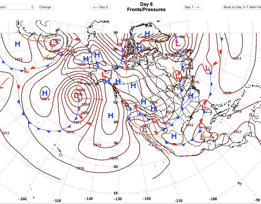
Here is that day 6 surface map.
-
That low pressure area far off the western Washington coast waxes and wanes and doesn't seem to make any improved development. However, the 3-7 day forecast surface map shows good development by the day 6- 21 April- with a 986mb surface center. That could be a player if it can get far enough east. No moisture is going north to nourish that low. Seems unlikely to break through the barricade high pressure. Good moisture flow from the ITCZ 145 W area as the sub-tropical jet throws the moisture to the extreme southern portions of the US. That's helping big rain in the Gulf Coast and a healthy patch of storms in south Texas. Even without a jet to stream moisture north, if more moisture were to leave the ITCZ 170 W area, the Hadely Cell circulation could put added moisture in the domain of the low, creating a strong storm system capable of busting through the blocking high. While dry air of the high is more massive than water vapor alone, the shear weight of dense- (condensed) water particles in strong storms cells can displace the dry air of the high. Strong enough to wedge the high out of the way and move eastward.
-
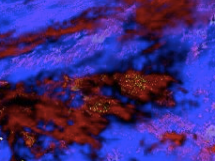
The thunderstorm activity at 170 West of the ITCZ has increased so the MJO for the area is turning positive. It is at this limited time window that the aquariusradar would be most effective. The natural forces of the active ITCZ loft huge volumes of water to great heights with CN and subsequently the aquariusradar, operating from the southern side of the line of storms, slows or stops that growth just prior to the start of maximum rainfall. The CN storms further north take up the available moisture. At the northern extremity of the ITCZ storms, aquariusradar targets these enhanced storms. A large quantity of moisture is held aloft as the storms leave the area of the active ITCZ. Held aloft, an increased portion of the rainfall of the ITCZ is transported north by the Hadely cell circulation. This would require two or more ships equipped with the aquariusradar. A nighttime RGB image of lightning immersed in the CN multiplex of CN storms near 170 West.
-
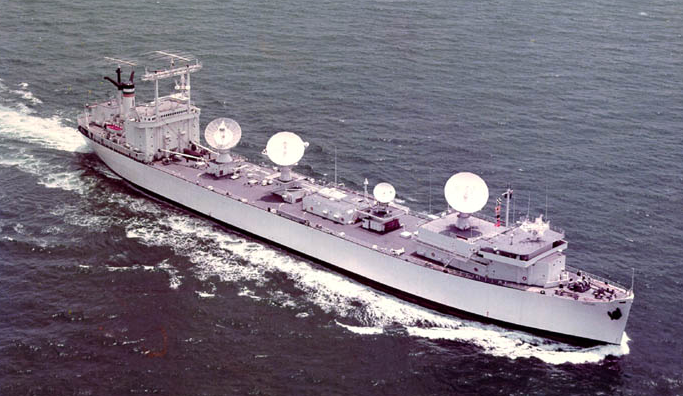
The scenario can’t make any progress as the MJO is in a negative phase for the 160-170 West longitude area so the ITCZ in this zone is very quiet. No moisture is being drawn north. That patch of low level water vapor off the Central California coast isn’t receiving any nourishment and the low circulation can’t shoulder its’ way east as the high continues to block the flow. The dry air of the high is more massive than the thin clouds and water vapor. The dry air of the blocking high desiccates the light cloud cover at the coastal edge. If some heavy weight clouds, like CN, were in the mix of northward moisture flow from the ITCZ, the low pressure could grow to a powerful storm that pushes the high out of the path and continue on the east- northeast track it naturally follows. In order to grow into a powerful storm, the low cyclone needs more moisture and the aquariusradar could provide that moisture by operating from ships at sea. With the addition of GPS and modern NWS type radar pointing information, the technology is available as seen in the photo of this NASA ship used during the Apollo program of the 1960s. By tempering CN cells from the south side of the storm line of the ITCZ in the 150-170 West area, when the MJO is in the positive phase, CN cells that are to the north take up that extra moisture. Aquariusradar slows the growth of CN cells and keeps the water aloft and ultimately prevents the cell from raining down the majority of water lifted by the natural forces and instability of the ITCZ so that the anvil tops of CN cells can leave the area of the ITCZ containing massive amounts of water aloft. The Hadley cell circulation steers these water packets into the domain of the low and provides for growth. The low can now pierce the high pressure shield and rain to the west coast. There is a little more activity in the 170 longitude of the ITCZ this morning and the MJO may be approaching positive in that area. It is cold in Europe and the cool in Eastern US. Winter in the Northern Hemisphere is not quite over.
-
President Biden's infrastructure plan doesn't have any ideas about the need for water infrastructure for the western states. Research grants for ideas like Sawyseekers would be something to add to the legislation. Another idea is a national network of aqueducts to connect wet and dry areas. Consider an aqueduct right down the middle of interstate I10 from Northwest Florida to Phoenix Arizona. The federal government already has the property rights of way. Florida, Alabama, Mississippi, Louisiana would like to sell their excess water to Arizona. West Texas, and New Mexico would like to buy some of that water as well. With Phoenix getting all of its' water from the aqueduct, Colorado River water could go to other users; mostly California. The aqueduct could be open ditch with a lesser capacity in enclosed piping; sparkling clear water from Florida springs in the pipe for home use in Phoenix. Agriculture quality water from the hundreds of rivers and streams of the Gulf Coast flows in the open ditch. The water in the ditch can also serve as a energy storage mechanism; when electrical demand is low, the wind and solar energy produced in this region is used to pump aqueduct water up to storage reservoirs. The stored water is then released for electrical generation during the heavy demand daytime hours. So the cost of aqueduct pumping is minimized. If the nation can build multiple east-west transportation interstate hi ways, why could we not build at least one big water aqueduct from east to west?
-
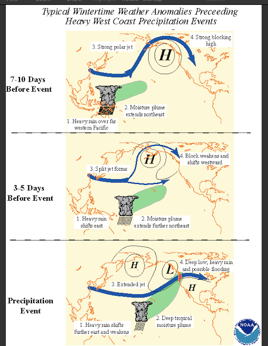
Using the low level IR water vapor images as reference, that low pressure trough has survived and now has pushed down as far as just north of the Hawaiian Islands. Kinda looks like the branch tributary jet shown in the NOAA diagrams. The progress might be similar to the "3-5 days" sketch in the NOAA scenario. Trouble is there is no big plume of low level moisture near the W 170 degree region. Some small amount of low level moisture is seen in Southern California- just enough to keep lenticular clouds downwind of the Mt. Whitney, Russell, Williams area. Maybe the larger moisture plume near W 150 will be intercepted as the trough continues south. Waiting to see with fingers crossed.
-
The SCOTUS has handed Georgia a win in the ongoing battle for Chattahoochee/Appalachia river water. The court couldn't find how Florida was damaged; how much is too much water usage? The real problem is not insufficient water flow down to the oyster estuary of Appalachia Bay; the problem is polluted water. In addition from the huge urban runoff from Atlanta, the farmers in the Georgia cotton and peanut along the rivers banks continue to use Roundup and other posions for weed control. These weed killers are biodegradable by UV light and soil microbes, but once the posions get into the water column they float down to the Bay where it kills the tiny green phytoplankton (plants) that oysters feed on to grow. The issue won't be resolved until this is prevented by subsidizing the additional costs of conventional mechanical tilling for those farmers right on the river drainage. The entire Southeast oyster industry has been destroyed by Roundup like chemicals.
-
Jumping ahead of several more applications (hail suppression and tornado tempering), I think aquariusradar could be used in combating the western states drought. Several days ago, an upper level low developed off the west coast. The low is maintaining and perhaps deepening as it moves northeast. Some CN lightening is observed on the north side of the circulation. In the same time period, a large patch of moisture is streaming away from the ITCZ and is now southeast of the Hawaiian Islands. Looks like maybe some of that moisture could eventually be pulled into the circulation. Is this a developing Pineapple Express as illustrated in this NOAA graphic?...or will the blocking high pressure squash this as well?
-
The sketches used in the previous post are also used to illustrate the urban stormwater abatement case. In recent days Nashville, Tn. was pummeled again by training CN thunderstorms that flooded the city. Aquariusradar, with a narrow pencil beam antenna pattern, radiates microwave energy directly on the base of the CN cloud headed for the city center. That thunderstorm is tempered such that it produces less rainfall on the rooftops and concrete of the city center that cannot absorb any water. The flood waters of the city center rush out and aggravate the flooding on the city suburbs. Other CN cells outside the city center take up the added available moisture and grow to produce more rainfall in the greenbelt or aquifer recharge that surrounds the city. The total local rainfall is unchanged. The rainfall is moved from flood to storage. Using cloud seeding to "make it rain" is cheating mother nature by taking someone's rainfall. Cloudseeding is weather modification. Aquariusradar cannot make it rain more. It can only move that excess rainfall to storage. Aquariusradar is weather moderation.
-
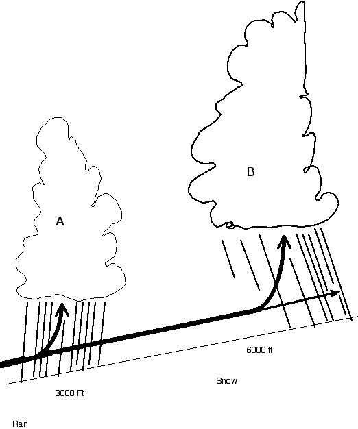
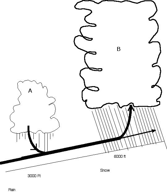
The best way to blunt the forces of drought is water storage. Here are some ways aquariusradar can be used to store water while helping a poor weather condition. Snowpack enhancement is available all along the West coast of Washington, Oregon, and California. The intense rainfall of Infrequent atmospheric rivers (Pineapple Express) can flood the coastal areas of the western coast. Mountain snow is often the blessing of the atmospheric rivers as it encounters high peaks. Aquariusradar targets CN cells as they approach and cross over the coastline and diminish the rainfall of the CN cell over the flood zone. By heating the water molecules at the base of the cloud by a tiny amount, adiabatic leverage is obtained. The condensation rate is slowed and the latent heat is preserved in the water molecule. The rapid growth of CN is dependent on available moisture and the released latent heat of condensation. CN clouds rarely occur alone. CN clouds compete for moisture and when a CN cloud has inhibited growth, surrounding CN cells will take up the extra available moisture. In this example, those storms not tempered and which continue towards the elevation of the snow line of coastal mountains will produce more snow. Rainfall is moved from flood to snowpack storage.
-
In the 1960s, Dr. Edward Lorenz, pioneer weather researcher, discovered the important math that later helped develop and defined the physics of chaos theory; later responsible for the ideas about fractals and popularly called the butterfly effect. Most of this is really beyond my scope and grasp of mathematics. But the important point about why weather is impacted by Lorenz's discovery is how much weather is controlled by dynamics and that the biggest dynamic rain making cloud is the cumulonimbus (CN ) thunderstorm. Dr. Lorenz discovered that in natural fast developing systems like CN clouds, that are best described by dynamic non-linear equations, tiny changes at the start of a chain of repetitive actions has large effects on the final outcome. Microwave energy can heat (speed up) water molecules. Water for tea and coffee can be heated to the boiling point with the home microwave. At a much greater distance, the aquariusradar can heat the water molecules at the base of the developing CN cloud only a tiny amount. Repeated over and over, that tiny amount of heating inhibits the coalescence of water molecules around seed dust particles, ice crystals, etc. and the growth of targeted CN clouds is slowed and stopped altogether in continued for a long time. Aquariusradar slows the growth of targeted CN and inhibits rainfall. The next post will discuss how that inhibition and competition from neighboring CN clouds can be put to advantage.
-
Before moving on to talk about my moderation method, a few words about how I chose the the term aquariusradar. Aquarius is the deity of the ancients frequently called the water bearer and the so named constellation is often depicted as a figure carrying a water urn from which water pours. Sometimes good sometimes bad, depending on the ancient civilization, I prefer to think of it as in Ancient Egypt: In Egyptian Mythology, people who populated dry lands thought of Aquarius as a charitable deity who made rainfall when they needed it for farming. Hey, maybe a little over the top, but I had to call it something. As the name implies, radar (microwave energy) is used to transport water (rain) from an undesirable location (flood) to desirable storage (snowpack, urban greenbelt, aquifer recharge, etc.) And just as obvious, it won't work unless it's already raining. It stands to reason if the coast is receiving gentle soaking rain, it won't be used. But if flood is occurring on coastal rivers , then it can be used to transport excess rain to higher elevations or further away from the coast to possible storage. Next- the scientific background.
-
Weather modification means somehow, on a local or regional basis, to dramatically change the character of weather. It's not raining- changed to-it's now raining. Weather moderation means modestly changing the existing weather for a better, more beneficial condition. Its raining too much in a flood prone area- changed to- some of the excess rain is translocated to a drier area. Many Western states now attempt weather modification with cloud seeding using silver iodide crystals or salt and smoke particles. The effectiveness is still under study. California, for example, uses cloud seeding in an attempt to increase snow in the Sierra Mountains. By definition, moisture in the atmosphere must be available and that moisture that comes down as rain is removed from the atmosphere. It's a dramatic change because without cloud seeding maybe that moisture would provide snow in the Utah mountains. In the West, stealing someone's water is bad juju . On the other hand, if it's raining so much that Western coastal areas are in flood, somehow moving that excess rain to the high mountains as snow is termed moderation. Most of the rain that floods the coast is lost to the sea. So moving some of that excess moisture (as rain-runoff) from the coast to the high mountains (as snow-stored) is beneficial. It's raining-Moderation applied-it's still raining. No moisture is stolen from the atmospheric river. The weather modification case is bad as moisture that could be shared or intercepted by other mountains of the West is "stolen" by the Sierra cloud seeding effort. The weather moderation case is beneficial in that it saves moisture that would otherwise flood to the sea and saves it as snow. My following post will discuss my moderation method and the evidence I have gathered to demonstrate that the method works.
-
The melting Greenland ice cap is caused by warming air over the arctic. The weight of the thick 10,000 ft ice pushes down on the interior of Greenland such that the mantle rock is depressed below sea level. Long term, as the ice melts sea level will increase as a result of the added water to the oceans, the mantle will rebound to some level above sea level adding to sea level rise. If a volcano is erupting in the interior, the melted ice water would be trapped in the interior depression created by the massive weight of ice. Any volcanic eruption on the coast or interior would create enormous blasts of steam through cracks in the ice and would be readily detected by satellite. Even if hot rocks of the mantle were melting ice, that doesn't explain the lakes of melted ice on the surface thousands of feet above the earth's mantle. Ice is a good insulator.
-
I posted the following on Swayseeker "heat air at ground and air will rise " thread; I think I should have posted my reply here...... I think Swayseeker has a plausible idea. The good example might be the Salton Sea and the peak of the Oronocino? Mountain just east of the sea. Swayseekers tunnel might be a plastic covered greenhouse funnel/tunnel/chimney that runs(10 miles ?) from the Sea surface to the peak (3500 ft?). With local heating of the sea, moisture laden air begins to rise and move through the chimney delta that may cover several acres immediately above the surface of the sea and into the chimney stack at say 10:am and continues until near 5:pm on a summers day. The plastic framed stack winds along the ground up the mountain ridgebacks and at some point (elevation 2000' ?)the temperature of the plastic walls of the chimney stack fall below the dew point(added now:dew point of the air/water vapor in the chimney/tower) and water vapor condenses on the walls and runs back down hill to some collection point. The latent heat released keeps the chimney draft working to pull in more moisture laden air at the sea level. The pathway of the chimney will have to be maintain uphill always to keep the draft from stalling out. That covered pathway, with a cool and moist environment, could make an interesting hiking path. Didn't Swayseeker talk about this in another thread? California needs every drop of fresh water. Wouldn't that tiny stream of water be useful now in this horrific drought.
-
I think Swayseeker has a plausible idea. The good example might be the Salton Sea and the peak of the Oronocino? Mountain just east of the sea. Swayseekers tunnel might be a plastic covered greenhouse funnel/tunnel/chimney that runs(10 miles ?) from the Sea surface to the peak (3500 ft?). With local heating of the sea, moisture laden air begins to rise and move through the chimney delta that may cover several acres immediately above the surface of the sea and into the chimney stack at say 10:am and continues until near 5:pm on a summers day. The plastic framed stack winds along the ground up the mountain ridgebacks and at some point (elevation 2000' ?)the temperature of the plastic walls of the chimney stack fall below the dew point and water vapor condenses on the walls and runs back down hill to some collection point. The latent heat released keeps the chimney draft working to pull in more moisture laden air at the sea level. The pathway of the chimney will have to be maintain uphill always to keep the draft from stalling out. That covered pathway, with a cool and moist environment, could make an interesting hiking path. Didn't Swayseeker talk about this in another thread?


