

LowerGarfield
-
Posts
2283 -
Joined
-
Last visited
Everything posted by LowerGarfield
-

January 2024 Weather in the PNW (Part II)
LowerGarfield replied to Meatyorologist's topic in West of the Rockies
Are you originally from Eastern Canada? If so, how do you like your climate vs the old one? -
January 2024 Weather in the PNW (Part II)
LowerGarfield replied to Meatyorologist's topic in West of the Rockies
NWS Spokane puts me under a WWA from 1am-4pm tomorrow and 1am Thur-4pm Fri. I personally think they are jumping the gun for WSW since the Euro and GFS widely disagree. Surprised about WWA but not as much since it's tonight. URGENT - WINTER WEATHER MESSAGE National Weather Service Spokane WA 244 PM PST Tue Jan 9 2024 ...WINTER WEATHER ADVISORY IN EFFECT FROM 1 AM TO 4 PM PST WEDNESDAY... ...WINTER STORM WATCH IN EFFECT FROM LATE WEDNESDAY NIGHT THROUGH FRIDAY AFTERNOON... * WHAT...For the Winter Weather Advisory, snow expected. Total snow accumulations 1 to 3 inches with locally up to 6 inches on the Camas Prairie. Winds gusting as high as 45 mph. For the Winter Storm Watch, heavy snow possible. Total snow accumulations between 5 and 10 inches possible, locally lower amounts of 2 to 4 inches in the Lewis Clark Valley . Winds could gust as high as 45 mph. * WHERE...Clarkston, Peck, Culdesac, Lewiston, Kamiah, Pomeroy, Winchester, Lapwai, Craigmont, Gifford, Lewiston Grade, Nezperce, Alpowa Summit, and Soldiers Meadow Road. * WHEN...For the Winter Weather Advisory, from 1 AM to 4 PM PST Wednesday. For the Winter Storm Watch, from late Wednesday night through Friday afternoon. * IMPACTS...Travel could be very difficult. Winter travel conditions could impact the Wednesday morning and evening commutes. Gusty winds could bring down tree branches. PRECAUTIONARY/PREPAREDNESS ACTIONS... Slow down and use caution while traveling. In Idaho, for the latest road information in Idaho, call 5 1 1. In Washington, for the latest travel information in Washington, go to https://wsdot.wa.gov/travel Monitor the latest forecasts for updates on this situation. -
January 2024 Weather in the PNW (Part II)
LowerGarfield replied to Meatyorologist's topic in West of the Rockies
Then someone will make an ill-advised low budget part 4 featuring the icon that no one likes. -
January 2024 Weather in the PNW (Part II)
LowerGarfield replied to Meatyorologist's topic in West of the Rockies
Can someone explain how composite reflectivity works? How is is different from the regular maps? -
January 2024 Weather in the PNW (Part II)
LowerGarfield replied to Meatyorologist's topic in West of the Rockies
Also for the Pac 12 championship (and regular season). -
January 2024 Weather in the PNW (Part II)
LowerGarfield replied to Meatyorologist's topic in West of the Rockies
all of WA except that area in Portland's sphere of influence. -
January 2024 Weather in the PNW (Part II)
LowerGarfield replied to Meatyorologist's topic in West of the Rockies
There's a very good analogy for 2024 but I'm not going any further. Anyway I am on Team GFS! -
January 2024 Weather in the PNW (Part II)
LowerGarfield replied to Meatyorologist's topic in West of the Rockies
could they notify the coast guard or navy and see if they could land on a carrier if they couldn't make it to North America or HNL? -
January 2024 Weather in the PNW (Part II)
LowerGarfield replied to Meatyorologist's topic in West of the Rockies
Winds are howling...It sounds like high tide at the Oregon Coast. -
January 2024 Weather in the PNW (Part II)
LowerGarfield replied to Meatyorologist's topic in West of the Rockies
How do you get the NAM to show on tropical tidbits? -
January 2024 Weather in the PNW (Part II)
LowerGarfield replied to Meatyorologist's topic in West of the Rockies
I thought it was a Max 9? -
January 2024 Weather in the PNW (Part II)
LowerGarfield replied to Meatyorologist's topic in West of the Rockies
I want to know where the NWS is thinking 2-3 inches for Spokane and probably more for @Phishy Wx unless they were relying on the GFS which is possible since it was published just before the Euro. -
January 2024 Weather in the PNW (Part II)
LowerGarfield replied to Meatyorologist's topic in West of the Rockies
Lucky no damage but wow, that's a big branch! -
January 2024 Weather in the PNW (Part II)
LowerGarfield replied to Meatyorologist's topic in West of the Rockies
NWS Spokane is hedging. They waited as long as possible this morning to post their most recent AFD and it is pretty much a copy pasta from the last two AFDs. " 000 FXUS66 KOTX 091947 AFDOTX Area Forecast Discussion National Weather Service Spokane WA 1147 AM PST Tue Jan 9 2024 .SYNOPSIS... Snow will continue over much of Eastern Washington and North Idaho Today while some areas transition to rain. Strong winds Tuesday will lead to blizzard conditions in the Cascades and Blue Mountains. Winds will also be strong in Eastern Washington and North Idaho as well. The weather pattern will then turn much colder on Thursday into early next week along with additional chances for more snow. && .DISCUSSION... Tuesday through Thursday: Looking at radar and satellite it is very evident this fast moving weather system is delivering a punch of moisture to the region. A nicely wrapped Low is moving into Victoria Island and through the Strait of Juan de Fuca early this morning. The backside of the cloud shield and the warm front is pushing through the Cascades and eastern Washington saw a change over from snow to rain at about midnight. Since then (as of 2 am PST) temperatures from south-central Washington through the West Plains have warmed to 36-39F degrees. Southeast winds have been gusty 24-30 mph and continue to slowly make the shift to the south and eventual southwest. Wenatchee to Chelan and Omak remain 27-29F degrees and reporting snow. Given the warm front arrival a bit earlier, will be ending the winter weather advisory for the Basin and WA Palouse including Spokane a bit early this morning. The Cascades continue to be under the brunt of the convergence zone. Webcams from Snoqualmie to Stevens Pass have worsened in the last few hours with lower visibilities in snowfall. The blizzard warning will take affect shortly as conditions are beginning to become more widespread. Going forward today, the winds are forecast to begin shifting out of the southwest between 3 am and 6 am, according to the latest HREF and UW-wrf guidance. All things considered with wind, we remain on track for the strongest winds to peak with widespread sustained speeds of 20 to 30 mph and gusts 40 to 60 mph now through this evening, about 8 - 9 pm. The ensembles have continued to paint the Basin, the Palouse, and the West Plains through Couer d'Alene as the prime areas to see maximized low level winds. Additional snow, outside the Cascades, will focus on another round late this afternoon/early this evening in Northeast Washington, the Selkirks in north Idaho and the Silver Valley. Timing of the cold pool aloft (500mb temperatures) will move east and result in another unstable environment conducive of producing periods of 1"/hour snowfall rates (60-80%) for areas near Lookout Pass. An additional 6 to 10 inches of snow in the Idaho mountains looks favorable with the west-northwest flow. Wednesday and Thursday we will see two weather features rotate through bringing the very cold air from the north into the Inland Northwest. As we've been watching this trough wobble from east to west as it is anticipated to dig south; pin-pointing exactly where the coldest arctic air will slide south with regard to the Northern Rockies, it appears west of the Rockies will see those very cold temperatures. Areas that will favor additional snow on Wednesday will be under the northwest flow. Idaho mountains and the Palouse down to the Camas Prairie will see accumulations under this cold influence. Along with this northerly flow of cold air, winds will shift from the west to north and become breezy Thursday. Gusts 25 to 35 mph during the day Thursday will also make the temperatures begin to take a sharp turn downward, dropping aroudn 20-30F degrees to near zero by Friday. /Dewey ...Frigid Temperatures to end the week... Friday through Monday: Bitterly cold and unsettled conditions are anticipated through much of the extended forecast. Below zero low temps are expected for many locations each morning through Monday, especially north of I-90. Chances for snow are forecast for nearly every day, particularly across the mountains. That said, the best chances for accumulating snowfall are currently looking to occur from a Friday afternoon through Saturday night time-frame. Amounts are expected to range from 1 to 4 inches (with locally higher amounts) for the lowlands, with greater amounts across the higher terrain. Confidence in snow totals is not very high at the moment as considerable run-to-run and model-to-model inconsistencies remain at this time. /KD && .AVIATION... 18Z TAFS: Gusty southwest winds continue to increase and will remain gusty beyond 06z this evening for most locations. Low level wind shear has potential to impact the region and most air fields with a vigorous push of westerly flow above 2000 feet MSL. Expecting snow showers starting around 9-14z for eastern WA and North Idaho tomorrow. FORECAST CONFIDENCE AND/OR ALTERNATE SCENARIOS: High confidence in gusty winds today persisting beyond 00z, moderate confidence in strength continuing past 06z Wednesday. ------------------ " -
January 2024 Weather in the PNW (Part II)
LowerGarfield replied to Meatyorologist's topic in West of the Rockies
@Phishy Wx did you find it? Also what ever happened to @gusky I think they were supposed to be in Walla Walla this winter?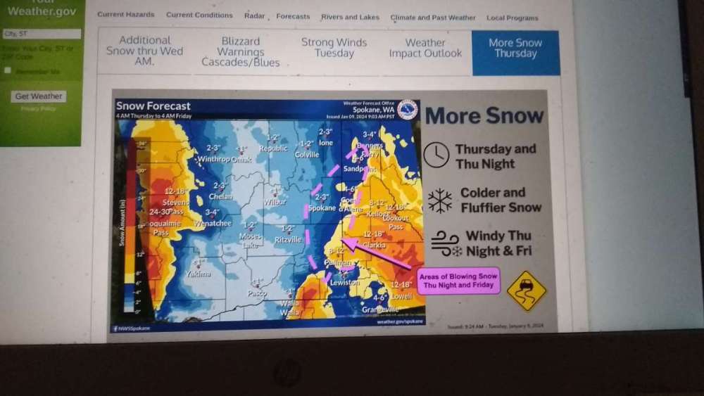
-
January 2024 Weather in the PNW (Part II)
LowerGarfield replied to Meatyorologist's topic in West of the Rockies
Click on "More Snow Thursday" it's the last side bar on the main page. It's new actually. -
January 2024 Weather in the PNW (Part II)
LowerGarfield replied to Meatyorologist's topic in West of the Rockies
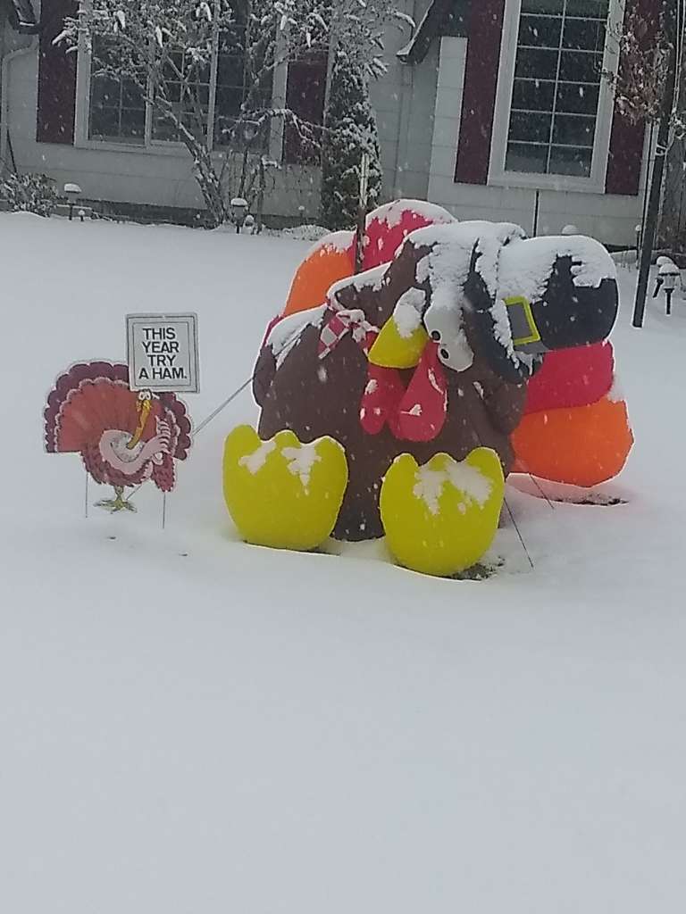
Here was a fun photo we took on Feb 7th, 2014 taken at my place 1 block from Whale Park (the beach) in Cannon Beach. Some friends built the surfman.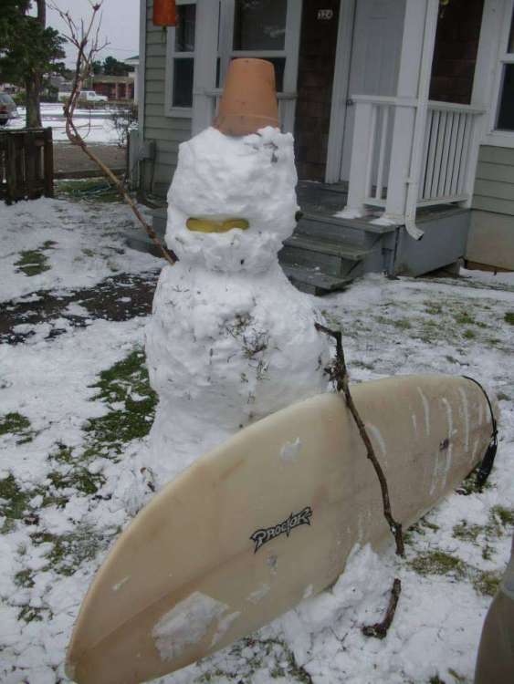
-
January 2024 Weather in the PNW (Part II)
LowerGarfield replied to Meatyorologist's topic in West of the Rockies
Yes I will say this. I had the pleasure of experiencing Feb 2014 (Cannon Beach) and Feb 2019 (Stanwood). Both were amazing. There was even enough for the Oregon event that the college kids built an igloo and it lasted for 2-3 days. No one came to the conference center for a week so all the employees had a super easy week and enjoyed the snow at the high tide mark. -
January 2024 Weather in the PNW (Part II)
LowerGarfield replied to Meatyorologist's topic in West of the Rockies
NWS Spokane is probably relying too hard on the GFS. Shocked they are going against the Euro even with the GFS bias. I mean obviously I'd love that but the GFS is on it's own other than partially the CMC.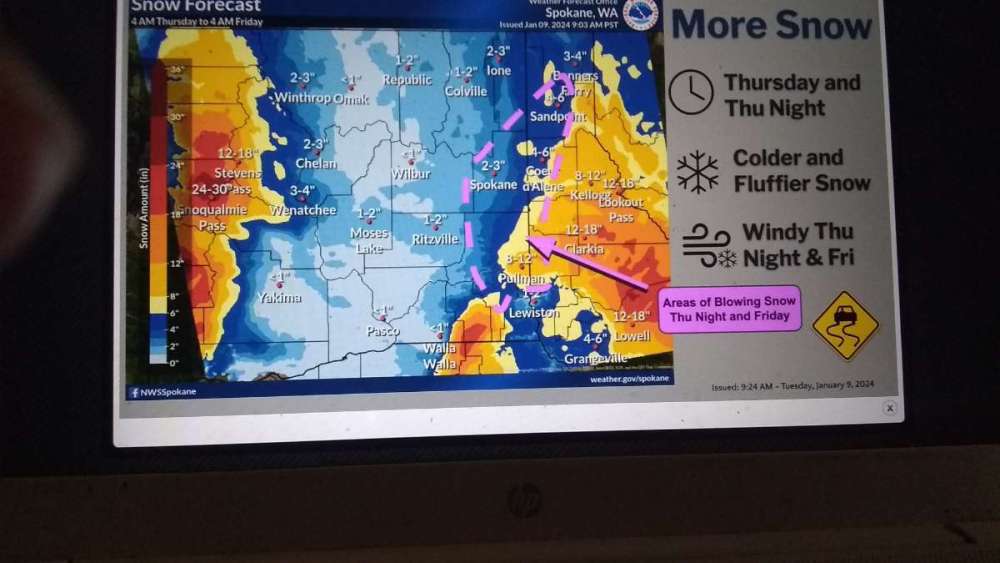
-
January 2024 Weather in the PNW (Part II)
LowerGarfield replied to Meatyorologist's topic in West of the Rockies
I'd even be okay if the Canadian verified. -
January 2024 Weather in the PNW (Part II)
LowerGarfield replied to Meatyorologist's topic in West of the Rockies
Still rooting for Team North America but its probably curtains for the sound and my area too. That Ensemble snow map shown a few posts above gives me something but still not that much and if Euro keeps trending south likely not. -
January 2024 Weather in the PNW (Part II)
LowerGarfield replied to Meatyorologist's topic in West of the Rockies
Except @DRG's cabin just south of Oregon and @MWG in Medford. -
January 2024 Weather in the PNW (Part II)
LowerGarfield replied to Meatyorologist's topic in West of the Rockies
Cliff -
January 2024 Weather in the PNW (Part II)
LowerGarfield replied to Meatyorologist's topic in West of the Rockies
C'mon Canada! Do it for the Blue Jays! -
January 2024 Weather in the PNW (Part II)
LowerGarfield replied to Meatyorologist's topic in West of the Rockies
We need someone in Longview or Chehalis.


