Doinko
-
Posts
5644 -
Joined
-
Last visited
-
Days Won
9
Everything posted by Doinko
-
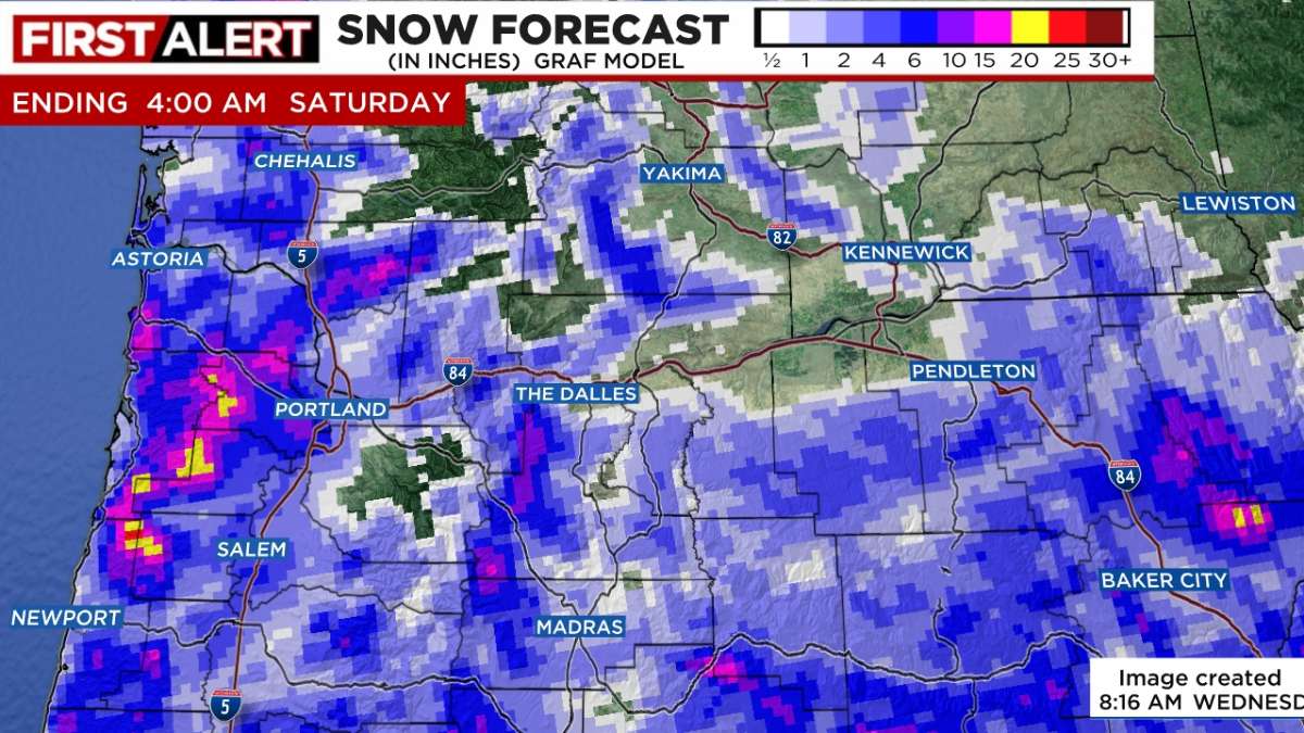
GRAF is solid that most of the precip will happen later but I'm getting a bit worried
-
Looks like we are at 37. Hasn't snowed since around 8:45. Hoping we can get some more soon
-
Just cloudy here right now
-
Down to 34 at PDX
-
Mark Nelsen says there's potential for a real snowstorm
-
Bit worrying but hoping it's wrong. Still a nice amount for sure though
-
https://www.kptv.com/2023/02/22/wednesday-morning-forecast-track-so-far-snowy-models-stressing-out-forecasters/ A quick update here is to tell you that we are very nervous about the late afternoon/evening/overnight forecast. That’s because several models continue to insist we get a real “snow storm” late this afternoon through tonight as temperatures cool down to freezing. For the 2nd consecutive run, Euro and Canadian models say that SOMETHING IS UP for tonight. Implying we get some sort of “January 2017 surprise”. That was the 1-4″ forecast that turned into 2-15″ in the metro area. No, I don’t really believe 28″ snow will fall in Beaverton in the next 24 hours with 1/2″ in Canby.
-
HRRR has some persistent banding right over and near the West Hills and my area.
-
Seems like we're being a bit shadowed at the moment. Do you think it'll even out and we'll do well later on? Most models show it but the last few years have been pretty disappointing here but this time it seems like a decent chance for us doing okay.
-
GRAF looks like mostly not phantom snow, and shows 8-10" here. Hoping it's right
-
Those are auto-generated maps, they have maps for the GFS/Euro and GRAF. They don't show all on air though, but this model nailed the valentine's day snow so it's definitely a pretty accurate one
-
Nothing on the ground here and it's stopped snowing, but the GRAF looks fantastic. Almost 10" of snow here
-
The GRAF increased totals to 10" for my area. Dumping snow already. Could be an amazing snowstorm
-
That bullseye is almost right over me. I'm really liking our chances
-
Dumping snow
-
GFS also looks good
-
Another model showing a foot+ here
-
How's the ICON for snow on WB?
-
ICON also looks good
-
RGEM looks great for Washington county
-
That's all actually from this current band of snow in Clark County. Doesn't show much after this point which is when the other models really dump the most snow
-
Mark Nelsen did mention the possibility of a subfreezing high on Thursday "But if skies remain partly-mostly cloudy and 4″ snow is sitting on the ground, this could be the first time we get a sub-freezing high after February 20th in 60 years!"
-
Has snow ended by that point? Shows over 1.5ft here!
-
High res GRAF and the RDPS also look amazing for here.
-
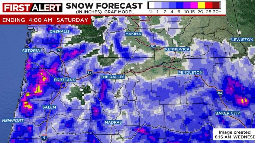
This track will tend to favor the central and south valley for potential accumulating snow with lower chances farther north into the Portland metro. This is reflected by probabilistic guidance capping chances for an inch of snow at generally 10 percent or less in the Portland metro while keeping central and south valley locations at 20-30 percen