


the_convergence_zone
-
Posts
1243 -
Joined
-
Last visited
-
Days Won
2
Posts posted by the_convergence_zone
-
-
Sun is out this morning in Seattle.
-
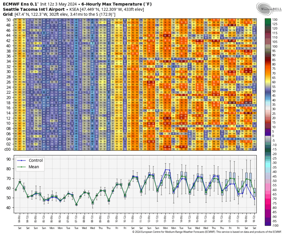
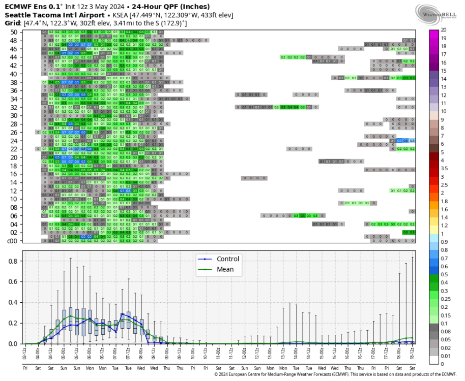
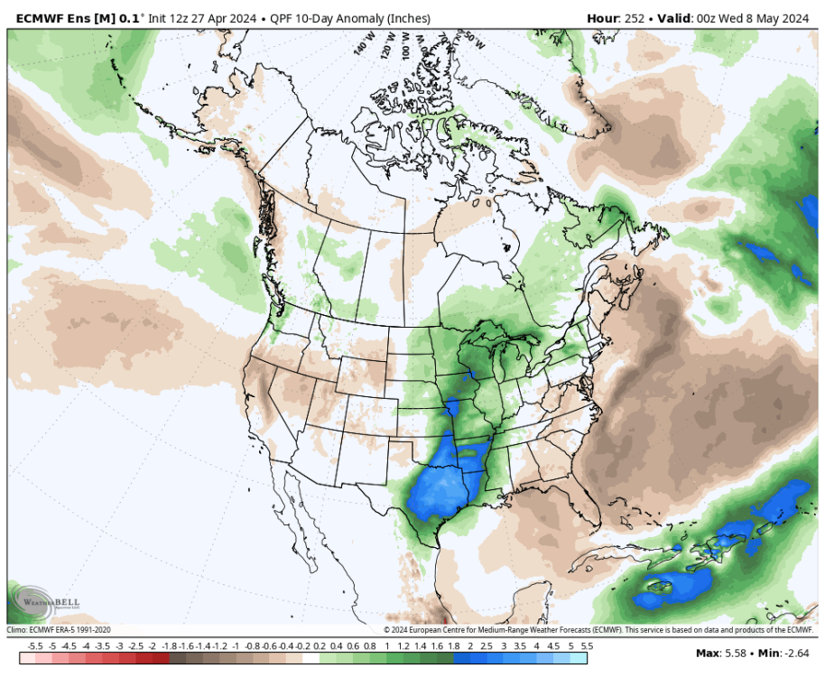
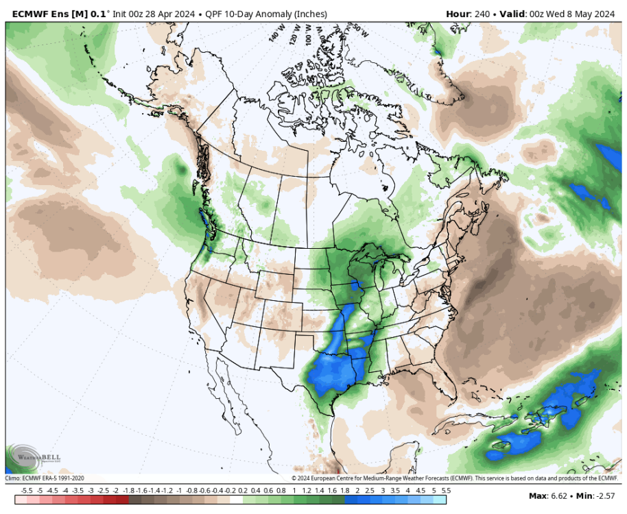
12Z EPS continues the KSEA rainfall rug pull and further ramps up the heat for the following weekend.
-
 2
2
-
 1
1
-
 1
1
-
-
26 minutes ago, Front Ranger said:
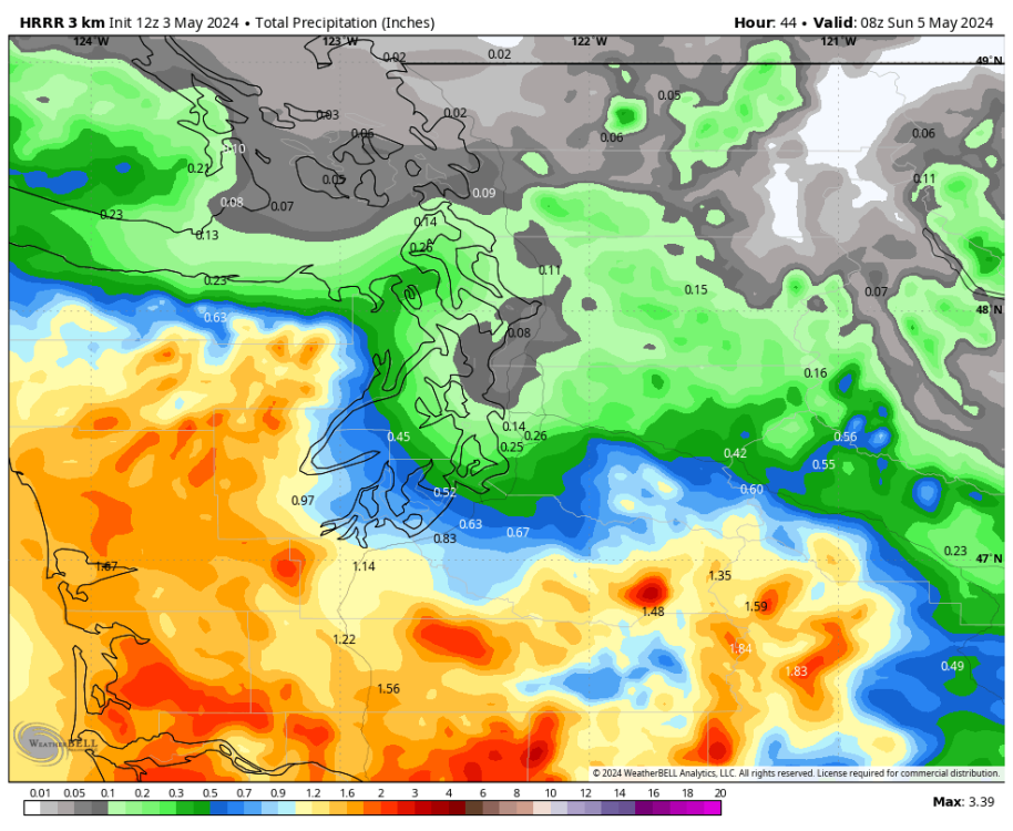
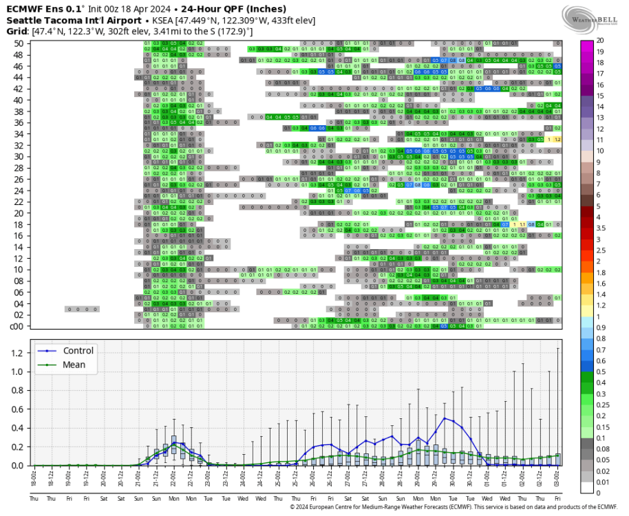
6z Euro continued to be more generous for the Seattle area at least, compared to GFS. But the GEM also moved drier with the 12z run, so good chance the Euro does as well.
Still a ton of spread in the ensembles. Initially it looks like the frontal band will struggle to make it past Olympia but eventually KSEA could get a decent soaking. Still a few EPS members in the 1” range but I think 0.5” remains the most likely outcome at least for the airport.
I would love at least 0.3” out of this, that will be enough to get everything nice and wet again. The sunnier spots in my yard are starting to look dry.
-
2
-
-
10 minutes ago, TT-SEA said:
It’s essentially a deformation zone tomorrow on the north side of the ULL to the south... and deformation zones often end up farther north than the models indicate.
We’ll see. Light precipitation events in spring almost always go the opposite way, the models have over predicted every single storm this spring at my location. The bigger one in late April was the only one that came close to the forecast.
-
So close to getting some drought relief, but it is increasingly looking like the Seattle area will get skunked this weekend.
-
 1
1
-
2
-
-
6 minutes ago, Port Angeles Foothiller said:
But @TT-SEA says we have had TONS of rain. We all must be lying and crazy.
I’ve had one decent soaking rain in the last 5 weeks.
-
1
-
1
-
-
11 minutes ago, Cascadia_Wx said:
Even last year things started browning up by mid-May.
5 days in the 80s sent the grass into summer mode.
-
1
-
 1
1
-
1
-
-
1 hour ago, Front Ranger said:
Meaning? Even if you don't get a ton of rain this weekend, models show enough over the next week that most locations should be close to normal in western WA for precip for the spring. And temps have been very close to normal.
Also, I said "most balanced for the region", not perfectly balanced for your backyard. If you can think of a spring since 2013 that has been more balanced for the region overall in terms of precip/temps, I'd love to hear it. Most have been stuck in lengthy, stagnant warm/dry or wet/cool patterns.
Ok, I get what you’re saying, there hasn’t been much blocking this spring and we’ve had weak systems interspersed with nice weather and temperatures in the normal-ish range overall. That’s fair.
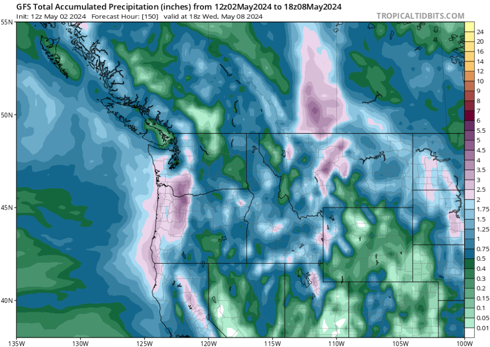
I do think the rainfall deficit is a big deal — maybe Oregon gets close to normal after this big storm but Sea-Tac is about 5 inches short this spring and they are going to get maybe 1 inch in the next week unless the forecast changes.

-
1
-
1
-
-
3 minutes ago, Front Ranger said:
By the time advertised ridging shows up (if indeed it does), it will have been a good 2+ weeks of solidly below normal temps and well above average precip.
Healthy spring. Assuming the period of ridging does materialize, 2024 will likely end up as the most balanced overall spring for the region since at least 2013...maybe even 2003.
None of that is true for Washington or British Columbia.
-
 1
1
-
1
-
-
Low of 39 here this morning. That’s the first time I have ever recorded a sub-40F reading in May at this location (since 2020).
-
1
-
-
31 minutes ago, Phil said:
88°F with that milky white sky.
 running out of time to score some decent weather before satan’s grip gets too strong.
Having trouble cracking 50 by noon here again. Brrrrrr.
-
 2
2
-
 2
2
-
-
0.01” overnight, so barring any showers today I’ll end April at 1.00” exactly.
Third straight cold April for the Seattle area with Sea-Tac at -1.1 F if I did my math right.
-
3 minutes ago, TT-SEA said:
Downtown Seattle getting shafted or just about to get the shaft!
I got clipped with that cell in West Seattle but it was just starting to strengthen at the time.
-
1
-
-
21 minutes ago, Port Angeles Foothiller said:
For the first time ever, I am on @Cascadia_Wx's side here. Summer is going to be hot and dry regardless of deep long spring troughing. We have aprox 6 weeks to load up the water table. WE NEED RAIN.
It’s not as bad as it could be due to the lack of evaporation and lack of snow melt. This pattern is arguably better for our hydrologic outlook than a rain dump from an atmospheric river with a 9,000 ft snow level followed by 80+ degree heat in the lowlands.
The streamflow in the Elwha looks pretty brutal though, even as the rivers on the windward side have bounced back to normal streamflow for now.
-
1 minute ago, TT-SEA said:
It's been a very nice spring so far. What is happening now and likely coming is quite anomalous. Don't be mad at me when I point out the nasty offset when it comes. On the other hand... a warm May with multiple heat events in this ENSO situation is usually offset the other way in the summer. I would be very leary of a warm May given my preferences.
This pattern is especially rough on the foothills if you like sunshine. You barely get any sun at all in North Bend with the constant upslope flow and cold air aloft.
Puget Sound is great at suppressing afternoon cloud cover this time of year if you happen to be close enough to take advantage.
-
1
-
 2
2
-
-
My April rain total is now 0.99” after a nice 0.18” this morning.
Did some gardening yesterday and the ground is nice and wet, I’m not too worried about being 2” short on rain in April, especially given the forecast. Not much evaporation this month thanks to the lack of an April heatwave.
-
1
-
1
-
-
Quite the wet trend on the 00Z EPS. Wipes out most of the warmth that was expected in about a week.
-
6
-
2
-
2
-
-
9 hours ago, SnowWillarrive said:
I’m scared for this summer
The 2030s-2050s are going to be rough.
-
1
-
4
-
-
18 minutes ago, Sunriver Snow Zone said:
Is it climo for the PS area to get a decent rainfall every couple of weeks in the peak of summer? I might believe a light sprinkle every 2-3 weeks, and maybe a decent rainfall once a month, but I have a hard time believing every 2 weeks. Maybe I'm wrong though.
And just so you know, in the summertime we get thunderstorms occasionally, the month of July here averages .66" of rain, which I doubt is any drier than Seattle.
In the last 10 years, Seattle has seen a whopping 3 rain events totaling more than 0.25” rain in July. That’s it.
In my experience, a drizzly convergence zone behind a marine push totaling 0.05” is where most of the July rain comes from.
-
1
-
 1
1
-
1
-
-
2 hours ago, Cascadia_Wx said:
Looks like some models want to immediately return us to a regime dominated by ridging, much like we saw in the mid-March to mid-April timeframe. Would be par for the course. Was hoping this cool and wet pattern would have a little more lasting power, but that’s asking a lot these days.
My hope going into this period was to get at least an inch at my location. I'm only at 0.73" for April as of today and it looks like I'm going to be shadowed all weekend. But the EPS has continued to look progressive through the week with a couple opportunities for another 0.25-0.5" event so I'm holding out hope. At least my 300 gallon rain tank is back to full so I won't have to use any tap water on plants for at least a month.
-
2
-
-
1 hour ago, TT-SEA said:
SEA had a sensor issue yesterday. Rainfall was not officially reported. We will never know how much rain fell there this month.

I bet Sea-Tac was around 0.55 based on neighboring stations. I ended up with 0.40” in West Seattle.
Great event for the mountains though.
-
2
-
-
The wind knocked over my mini greenhouse with all of my vegetable and flower starts. I salvaged as many as I could but it was a pretty big disaster from my perspective.
-
2
-
 1
1
-
 1
1
-
 1
1
-
-
38 minutes ago, Frontal Snowsquall said:
Just saw the radar loop. That’s as impressive as it gets. I saw reports of over 6 inches. Looks like the Dubai government said there wasn’t any cloud seeding missions during the storm. They have done it in the past though. I’m not a fan of cloud seeding or any other weather intervention done by man. We need to let Mother Nature run its course.
“DUBAI, United Arab Emirates — The National Center of Meteorology, a government task force responsible for cloud seeding missions in the United Arab Emirates, said it had not carried out the weather modification technique in the run-up to the heavy storms that caused flooding in places like Dubai.
The organization told CNBC that it did not dispatch pilots for seeding operations before or during the storm that struck the UAE on Tuesday.”
Cloud seeding is a form of public relations to say “at least we’re trying” to end droughts. Throwing some silver iodide in a cloud isn’t going to do anything to a storm that is large enough to produce appreciable precipitation. It might cause a few sprinkles from a cumulus cloud that otherwise wouldn’t have rained. There are also legal ramifications since it had been argued that cloud seeding is a form of theft — you are stealing the water from areas downstream of where you seeded.
The ironic thing is that project Stormfury got axed in the late 60s after they seeded a hurricane and it happened to make a left turn to the Eastern seaboard shortly thereafter. It would be funny if this makes them think twice about seeding in the UAE, although it’s a bummer that they didn’t seed this storm (or at least they claim to have not seeded it LOL).
-
3
-
-
Better than nothing, as long as these 0.2 storms don’t turn into 0.02 as they have been lately.


May 2024 Pacific Northwest Weather
in West of the Rockies
Posted
0.03” this morning, avoided the shutout. Wind is really cranking out of the NW.