


hlcater
-
Posts
2123 -
Joined
-
Last visited
-
Days Won
2
Everything posted by hlcater
-
maybe 3"/hr this is nuts.
-
Absolutely puking here. Gotta be 2"/hr. There's also been a few isolated reports of TSSN in S IA.
-
It's currently snow in IC. Not sure how long it has been, but there's not a whole lot of accumulation so far. Temp is 34, which may make accumulation difficult to start.
-
Some of these models really hammering home the existence of a weenie band somewhere in eastern Iowa tomorrow. Enough of them doing it (with some CAM and HREF support) that it will absolutely be something to look for. The 06z NAMs have it.
-
HRRR generally underdid the extent of surface WAA. CR/IC up to 34 while south central Iowa is approaching 40. Realistically, this probably doesnt matter a whole lot, but may push back the changeover to snow by an hour.
-
There is convective potential here with steep mid level lapse rates leading to some conditional instability, so a weenie band, or general high variance in snow amounts over short distances might be more prone to happen.
-
What in the actual **** is this GFS run lol.
-
The warm sector of this system is well timed such that we will rise above freezing late tonight and fall back below freezing before noon tomorrow. Looks like the amount of snow loss will be minimized.
-
We really are gonna try and make a play for 24-30" OTG...
-
Probably looking at 18-20:1 optimistically.
-
nice run from the Euro here. With the solid 00z consensus, almost certain we see headlines for snow and blowing snow in a few hours.
-
Solid consensus on the 00z runs for at least a 2-4" event for CR/IC followed by a period of blowing. I do wonder if we see headlines posted later tonight. DMX said they planned on it, but DVN cant seem to decide if they like the storm or not.
-
This morning Ervin was all in. Must depend on forecaster on desk. Getting conflicting signals each package.
-
Especially on top of an ice sheet. This is going to really maximize the blowing we get from ~40mph wind gusts
-
Throw it out. Doesn’t even agree with the 12z 3km.
-
I'd LOVE a good 4-5" snow before an episode of arctic cold. One thing to really keep in mind here is the possibility for ground blizzard conditions behind the arctic front as the GFSs are projecting 45-50mph wind gusts with and behind the passage. Combine that with freshly fallen snow and there could be issues. Not only that, freshly fallen snow on top of existing snow that will have a glaze of ice on it. Excellent blowing conditions.
-
Yea, there's a plume of steep mid level lapse rates and some conditional instability with this upcoming system/arctic front that would lead to convective snow potential, especially if the system trends colder.
-
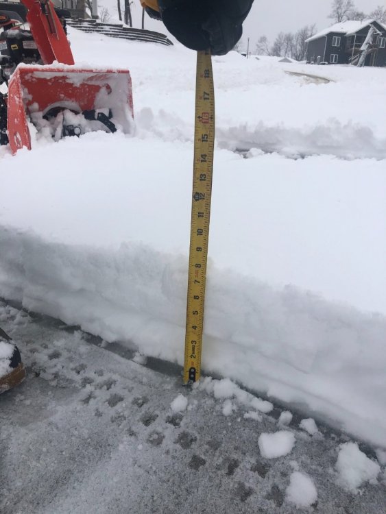
While verifying the 9.7” family got, they sent a pic of about 8.5” on the driveway. While still very impressive; that seems more reasonable to me and I think I’m gonna go with that instead.
-
The 12z euro took the major storm last night and shifted it to the east coast. Has a minor snow event for some a few days prior. This is the same energy that was originally progged to be a major storm. There has been a trend over the past 2 or 3 model cycles to become slightly more defined with this energy and perhaps spin up something modest before the cold presses in.
-
Family measured an average of 9.7” in Hiawatha. What on earth... I measured 4.2” in IC.
-
The thing with the euro is that system is COLD. Would be very high ratio verbatim. That would be quite something...
-
Really pathetic 1.1" just measured. I had higher expectations. 3.5" measured in Hiawatha meanwhile.
-
Yup. DAB- in IC so far. Lowering call to 2".
-
Just switched. God that was awful. Coincidentally, it switched late enough that the precip is starting to dry out. Still hoping to get lucky with 2-3".
-
The switch here looks to finally come about 2 hours later than forecast due to mesoscale screwage in johnson county. The models will be too generous with our snow because of it. A solid half inch or so of sleet down. So wonderful


