


hlcater
-
Posts
2123 -
Joined
-
Last visited
-
Days Won
2
Recent Profile Visitors
1093 profile views


hlcater's Achievements
")


-
Need the GFS to come on board. Still warm and SE relative to the ensembles, NAM, euro etc.
-
Big cluster of members near Hannibal likely bring the goods here.
-
This is likely to be the best storm of the season here despite the 3-4 hr dry period. The defo zone quickly made up for that and with 1-2 hours of snow left, will likely finish with 6-7". About in line with the model consensus. Nice to break the trend of events falling short of expectations this winter. IC area is closing in on 9-10" and Waterloo is reporting 2-2.5"; hell of a gradient and CR looks to have wound up just barely on the right side
-
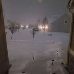
Eyeballing close to 6”. This band that’s been over me for the past 2 hours or so is really delivering the goods
-
Expecting to end right near 6" with a measurement of about 4.5" right now and probably another 1.5-2" on the way.
-
18z so far looking better than 12z
-
I see we are doing the T24 trend into the toilet
-
This is looking like a nice one.
-
Maybe just maybe we can crack 6" on this one.
-
Cant dislike the 00z suite for E IA tonight. 60 hours to go.
-
The airport is likely higher because they do hourly measurements negating compaction/melting. I’ve got maybe 1.5”
-
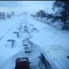
WSW issued * WHAT...Heavy mixed precipitation expected. Total snow accumulations of 3 to 5 inches and ice accumulations up to a tenth of an inch. Up to a tenth of an inch of sleet is also possible. * WHERE...Portions of east central and northeast Iowa. * WHEN...From 3 AM to 6 PM CST Thursday. * IMPACTS...Plan on slippery road conditions. The hazardous conditions will impact the morning. * ADDITIONAL DETAILS...A band of heavier snowfall is possible but the location of the band is uncertain at this time.
-
I'm not. Things could always be worse, but it is kind of a pet peeve. Though now the snow band is so narrow that you're riding the edge regardless.
-
I swear CR rides the edge in every. single. event.
-
Have exactly zero confidence in this storm due to the incredibly marginal thermos.


