
.jpeg.feb03d832ebda7a9cda8294198402b90.jpeg)

Stormy
-
Posts
2631 -
Joined
-
Days Won
5
Recent Profile Visitors
3096 profile views


Stormy's Achievements
")


-
I had to think of you last evening again when I saw the storms just missing you once again. I know the disgusting feeling esp. with the next 7 or more days looking dry and seeing most places all around you being well watered the last few weeks!
-
Heard the now familiar wailing of sirens well before the storm rolled through last evening, but thankfully it was just a good strong t. storm here, which is how I like them. It was not as visually awesome, but got nearly dark as it moved in. Max wind only 43 mph. I ended up with 1.32" which brings my July total to 3.62". Around 0.90" of that fell in 15 minutes. Had a few close lightning strikes as the rain was decreasing. It was getting a little dryish again so I really appreciate this rain. Places just to my se. are wetter as a very narrow swath (isolated storms) of heavy rain ( 1"+) fell there on the day Beryl crossed Illinois. Had only a few hundreths here when storms passed nearby at times last week and early Sunday.
-
So about how long did it take to upload it here? Just curious. A few days ago I started uploading short video clips and photos of our storm, but gave up as it was taking a coon's age! I don't have 5g service, but still....and maybe my signal or connection wasn't strong enough.
-
I got 0.12" this morning and an additional 1.30" or so this evening. It was blowing sideways so I don't know how accurate amount is this evening. The one rain gauge lid with slightly tilted so that's probably off. Still haven't checked those and was just going by my digital.
-
Yes I'm okay. I took a bunch of photos and videos. But I have storm clean up to do sometime so not sure if I'm going to have time to share right away.
-
Man this was not a good storm. My weather station had a top wind gust of 81 mph and a maximum rain rate of 12" per hour! It was like a blizzard. And it blew our one tree down, the neighbor's tree fell on the house, and there's twigs and branches all over the place. It's not the worst storm, but it's bad. That's the highest wind I've ever recorded on my station though, and that is slightly behind some trees and barn that's probably 40 ft high while the anemometer is over 34' high. I was using speech to text so I edited it.
-
A tornado warned rotating storm is just west of me heading my way! My phone went off about 20 minutes ago? It’s getting dark to the west and the thunder is rumbling.
-
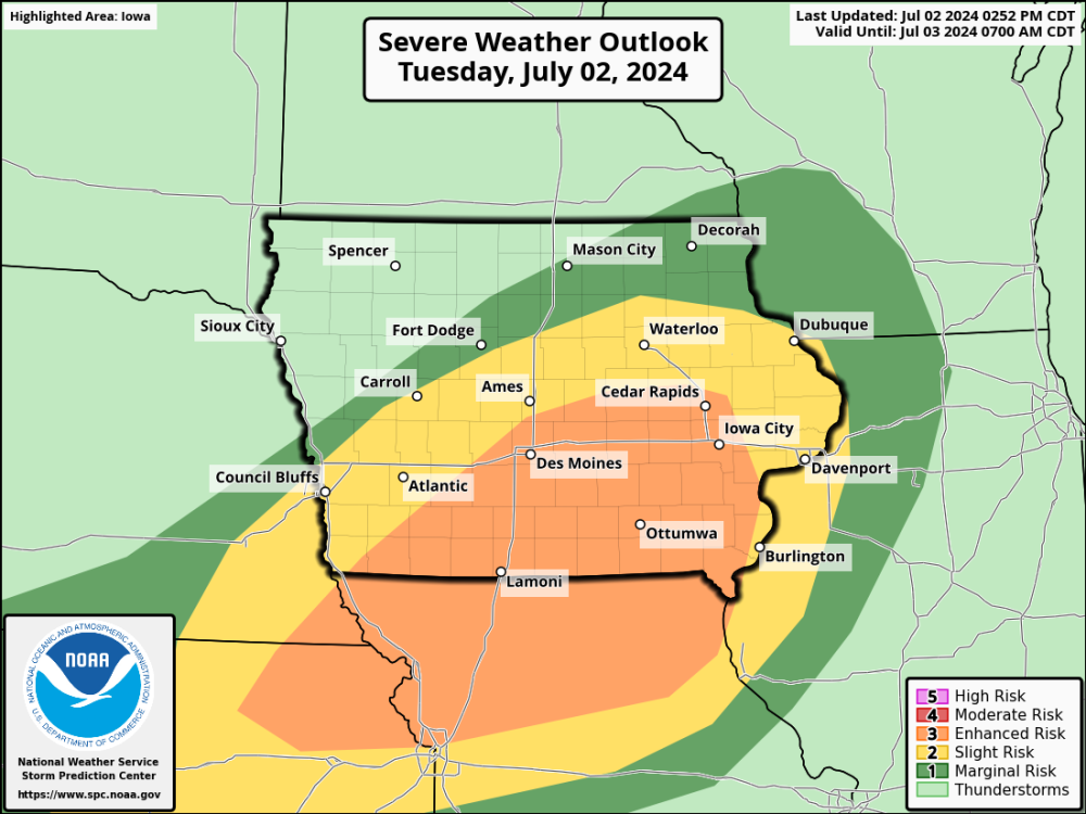
like what I’m seeing on the radar. Looks like southeast Iowa under the gun for heavy rain and severe thunderstorms. Enhanced risk of severe includes my county now.
-
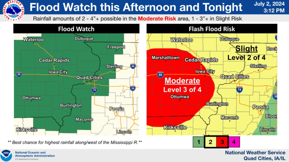
There's already a flood watch for the local river 4 miles south just because of forecasted rainfall! Though it's not particularly wet at my place part of the river basin got up to 1.50" of rain on Friday. DVN AFD sounds bullish, but we'll see.... https://forecast.weather.gov/product.php?site=DVN&issuedby=DVN&product=AFD&format=CI&version=1&glossary=1 I'm hoping for 2" this week before a possible dryer pattern. And currently, a formerly heavy cell is dying as it's moving in. I don't like dying storms and it's ridiculous how often that has happened in recent months when it's headed right at us, or then they pop just to the east.
-
Glad you got a good rain and much more than I got this time. Once again I was in a dryer hole with 0.79". Still a good rain, but too many lulls here. The last band had some thunder and lightning, but weakened overhead as it poured a few miles to the south. My June rainfall is below normal at 3.81".
-
Yes I was watching it closely and hoping the east moving cell would come my way after originally thinking It would pass to my sw. if It moves se. It finally turned se. just as it passed by over? @bud2380 before crapping out. Got plenty of pics of it. It missed me by 5-10 miles.
-
That happened here on Saturday too, and last evening as well! And I was surrounded by storms both times when it appeared to be heading right for me. It's kind of disgusting, but to a lesser degree because we got that other awesome nearly 2" rain last week. Yesterday morning I picked up a nice shower though of 0.23", but only a trace last evening. Storms early yesterday had lots of incloud lightning, but as as one cell developed right overhead and strengthened more it started spitting a lot of c/g bolts, which was exciting. It seemed like hours of constant rumbling last evening and plenty in the morning. It's been awhile since there was a day like yesterday, but still not much to show for it here except for a refreshing cool outflow!! I took lots of videos and photos, but I don't have time to upload attm. I just hope Friday pans out, especially for @OttumwaSnomow!
-
I read somewhere that northern IL is expecting a huge emergence of cicadas this year, but haven't heard if that actually occurred yet or not.
-
Saw the first fireflies the other evening and crickets started in the last week or two. No cicadas yet.
-
Just the opposite here with a heavy cell weakening right as it's moving in, and that's the second time that happened yesterday and too many times to remember since April. Still got nearly 0.20" from that line while my brother around 7 miles se. got nearly 1". But he only had around three fourth inch earlier yesterday so he almost caught up. Some of the dryer areas of eastern Iowa was in the heaviest band today except for down near @OttumwaSnomow's area. Hopefully he'll score the heavier amounts later Saturday! BTW, my daily total yesterday is 1.86" which was much needed and appreciated.


