


Anti Marine Layer
-
Posts
21693 -
Joined
-
Last visited
-
Days Won
8
Everything posted by Anti Marine Layer
-

2017 California/Southwest Weather Thread
Anti Marine Layer replied to May Grey's topic in West of the Rockies
Turned out to be a surprisingly sunny afternoon after another dark, misty, foggy morning. Was not expecting that at all. Still had quite a strong sea breeze to keep it from getting too warm, but at least it felt more like late spring than the middle of winter. -
2017 California/Southwest Weather Thread
Anti Marine Layer replied to May Grey's topic in West of the Rockies
Redding went from an afternoon high of 87 F yesterday to an afternoon high of 58 F today. The daily high temperature was 72 F at midnight, however. -
2017 California/Southwest Weather Thread
Anti Marine Layer replied to May Grey's topic in West of the Rockies
Julian has only reached 76 F so far today as compared to 86 F two days ago. Obviously that helped to weaken the inversion enough for San Diego (yes even the beach) to get its first sunshine in 5 days. -
2017 California/Southwest Weather Thread
Anti Marine Layer replied to May Grey's topic in West of the Rockies
Looks like there is a chance of some better clearing by late afternoon. If so, it would be one of the rare cases where a ridge of high pressure (currently moving out) created a DEEPER marine layer. -
2017 California/Southwest Weather Thread
Anti Marine Layer replied to May Grey's topic in West of the Rockies
What's going on here? San Diego looks like it is clearing out, but Orange County and inland still have drizzle as of 9:30 am. -
2017 California/Southwest Weather Thread
Anti Marine Layer replied to May Grey's topic in West of the Rockies
It is raining this morning, or a very heavy drizzle. This time of year can feel like the movie Groundhog Day. Usually a warm and sunny March and April means 6 weeks of exceptionally heavy May Gray and June Gloom. -
2017 California/Southwest Weather Thread
Anti Marine Layer replied to May Grey's topic in West of the Rockies
It's always great when a system drops temperatures 30 degrees in the mountains and deserts but wipes out the inversion and makes the beaches warmer. That's more of a March and April thing, however. Hopefully we will see some reverse clearing this weekend. -
2017 California/Southwest Weather Thread
Anti Marine Layer replied to May Grey's topic in West of the Rockies
5 days straight of no sun at San Diego Airport. Let's give 'em all a big round of applause. -
2017 California/Southwest Weather Thread
Anti Marine Layer replied to May Grey's topic in West of the Rockies
Sometimes the factors that frequently help make the marine layer become more shallow can set off mesoscale events that actually deepen the marine layer. Ridging to the north, rising geopotential heights, and offshore flow aloft from the north serves to bring warming via subsidence aloft, which helps to lower the inversion. At the same time the associated low level northwest flow over the outer waters (30- 60 miles offshore) jumps to 15-20 knots. This frequently generates a Catalina Eddy, which tends to deepen the marine layer, counteract coastal warming, and make the clouds more persistent near the coast. Even while the clouds over land are burning off, the advection of low clouds due to the eddy will frequently keep the clouds from totally clearing near the coast. If upper level heights and thicknesses are increasing, inland areas and areas at higher elevations see 24 hour temperature increases, while at the same time coastal areas are seeing lower afternoon high temperatures because of a more persistent marine layer cloud deck. Although the marine layer depth typically slopes downward to the north, and slopes upward to the east toward the mountains, a rather strong eddy will sometimes make the depth nearly the same everywhere. -
2017 California/Southwest Weather Thread
Anti Marine Layer replied to May Grey's topic in West of the Rockies
Again it could be something wrong with my body and maybe I should go to see a doctor about it, but a strong breeze at 65 F definitely has a wind chill factor, since it always feels warmer outside after the sun goes down than late in the afternoon on an overcast day as the sea breeze dies off. Wind chill charts do not include 65 F on them. -
2017 California/Southwest Weather Thread
Anti Marine Layer replied to May Grey's topic in West of the Rockies
There is no logical reason for the marine layer to be so deep when heights are higher than normal for this time of year. High pressure is supposed to create shallow marine layers not deep marine layers. Maybe this is part of climate change that high pressure no longer makes shallow marine layers. -
2017 California/Southwest Weather Thread
Anti Marine Layer replied to May Grey's topic in West of the Rockies
Much deeper marine layer this morning. It could even cool down the Inland Empire. -
2017 California/Southwest Weather Thread
Anti Marine Layer replied to May Grey's topic in West of the Rockies
Coastal eddy is really spinning in today's satellite animation. -
2017 California/Southwest Weather Thread
Anti Marine Layer replied to May Grey's topic in West of the Rockies
Visible satellite link (since NOAA is broken) http://images.intellicast.com/WxImages/VisibleSatellite/san.jpg -
2017 California/Southwest Weather Thread
Anti Marine Layer replied to May Grey's topic in West of the Rockies
Marine layer clouds hung around the beaches again all day today, with the clouds sitting atop the hills in the near distance at Laguna Niguel Regional Park, but it was sunny there and pleasant. June Gloom is in full bloom along the coast. -
2017 California/Southwest Weather Thread
Anti Marine Layer replied to May Grey's topic in West of the Rockies
San Diego had a rather low range of temperatures yesterday with a high of 67 and a low of 63. NOAA satellite is down, but the Intellicast one is up. Burnoff a little faster than yesterday. -
I signed the petition.
-
2017 California/Southwest Weather Thread
Anti Marine Layer replied to May Grey's topic in West of the Rockies
Another microclimate day today with marine layer cloud deck clearly visible from UCI, where it was mostly sunny and low 70s. Lake Forest is about 10 degrees warmer. Suprisingly Fullerton Airport is showing only 75 F. -
What is the strangest weather you have ever seen? For me it was on a trip to Arizona during the summer monsoon season. The road was completely dry and then you could see this wet area where it was literally pouring rain. So there was no rain and a big downpour within 100 ft of each other. We were suprised to drive into the sudden deluge. In my home town of Lake Forest it was when a thunderstorm developed above a deep marine layer. It was a typical gloomy morning with lots of low clouds. Then there was a large boom of thunder and it began pouring rain. Normally this would mix out the marine layer, and it did for a little bit before the low clouds redeveloped as the storm moved out and finally burned off by mid-afternoon. This was in early September.
-
2017 California/Southwest Weather Thread
Anti Marine Layer replied to May Grey's topic in West of the Rockies
NH1 First Alert Weather: 'June gloom' in the forecast http://www.nh1.com/news/nh1-first-alert-weather-june-gloom-in-the-forecast/ (Not California) -
2017 California/Southwest Weather Thread
Anti Marine Layer replied to May Grey's topic in West of the Rockies
Once again it all depends on your temperature perception. Some people have a sweatshirt in 65 degrees and others have shorts, T-shirt, and flip-flops in 45 degrees. I have been to the beach in mid summer with overcast skies, but usually the clouds are thin enough to let some warmth through, unlike the 4000 ft thick clouds we get in deep marine layers where it feels like mid Winter. Actually a very thin marine layer can make the ocean feel warmer. -
2017 California/Southwest Weather Thread
Anti Marine Layer replied to May Grey's topic in West of the Rockies
That's a very shallow marine layer there. Once the ocean warms up, summer marine layers are not as cold. Here's an animation from yesterday.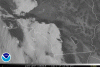
-
Twjgtmbiibomfty. Ymtwlr. Tbwpncbisbsawah.
-
2017 California/Southwest Weather Thread
Anti Marine Layer replied to May Grey's topic in West of the Rockies
June is the month that has the biggest warm up in average high temperature for Orange County and other areas near the coast. May stays pretty much level between 75 F and 76 F, while by the end of June the average high is around 81 F. However, actual climate data rarely agrees with averages. May was quite a bit of a roller coaster month with warm spells and cool spells. Hope to see things level off soon. -
It depends on the dewpoint or the humidity, of course. Typically dewpoints are in upper 50s to low 60s during the summer here, which is less than the East Coast. On a extremely dry day, such as when we get Santa Ana Winds, 80 in the shade can feel a little cool. Those days humidity can be less than 10%.

