CentralNebWeather
-
Posts
7132 -
Joined
-
Last visited
-
Days Won
34
Everything posted by CentralNebWeather
-

January 11-13 Major Winter Storm/Blizzard
CentralNebWeather replied to Hoosier's topic in East of the Rockies
I just saw my local weather app has me with 3-6” on Thursday. I had really no idea, as I’ve been focused on the first storm. -
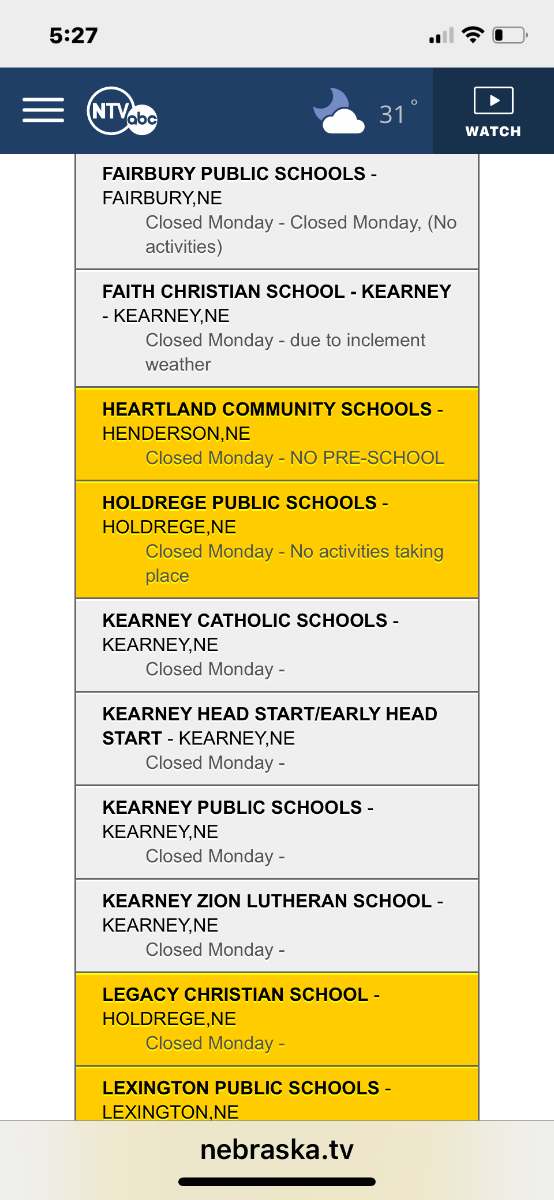
You can tell a storm is coming. Gusty east/southeast winds bringing in moisture. I don’t think there is anything going to be open around here tomorrow. Every school district is closed.
-
My area would be buried if we got this with forecasted 50 mph winds. My goodness.
-
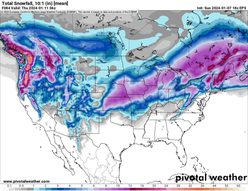
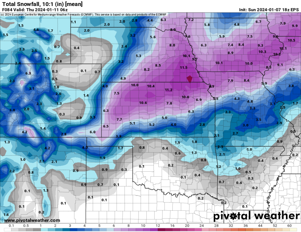
18z EPS
-
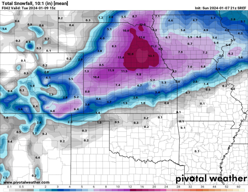
21s SREF
-
There will be very few schools open in the state tomorrow, and possibly Tuesday imo. I know that the times we get multiple days off in a row, it is the county that lets our superintendent know. With the winds being forecasted, it usually leads to an extra day of cleanup.
-
Yep. Just got the notification, no school here tomorrow. Did you hear our household screaming all the way to your house?

-
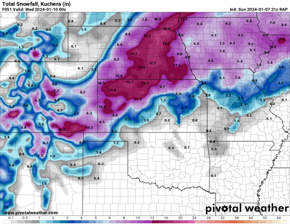
21z RAP. Whoa.
-
School closings are just beginning to get posted. Lots of anxious teachers and students across the state. Maybe not as many parents with the same anticipation.
-
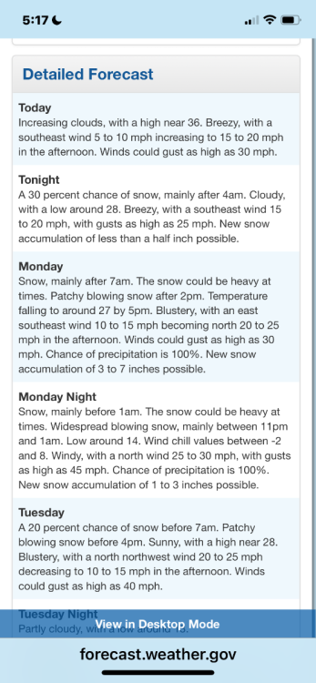
NWS Hastings afternoon disco: Monday afternoon through Tuesday morning, model guidance indicates a pretty heavy snow band that will set up over our central and west forecast area, and snowfall will likely be quite heavy over that area late Monday morning into Monday evening, with snowfall rates of 1"-2" per hour at times. Some of this snow is expected to be convective in nature, and areas of slightly stronger instability will only serve to enhance those snowfall rates...which would also increase snowfall amounts. As this system moves through, winds will become northerly and increase Monday afternoon through Monday night, with gusts of 35-45 MPH expected across the entire forecast area, with a few areas seeing gusts as strong as 50 MPH. This will cause near- blizzard conditions due to falling snow as well as blowing and drifting snow. Elected not to issue a Blizzard Warning at this time, but winds will definitely be strong enough and there will be enough snow...but not sure that the visibility will be reduced quite low enough to meet that criteria. That being said, travel conditions will be extremely hazardous late Monday morning through Monday night due to the snow and blowing snow...and the strong winds themselves may make travel dangerous, especially along W-E roads, including Interstate 80. Snow is expected to taper off overnight Monday night and into early Tuesday morning, but reduced visibility and difficult travel conditions are expected to be concerns throughout the day Tuesday before winds finally diminish Tuesday evening.
-
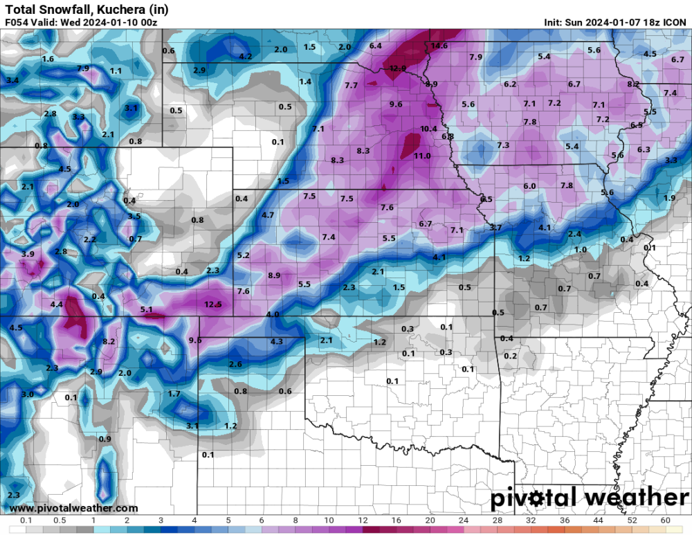
18z ICON
-
Winter Storm Warning just increased amounts for my area from 4-6” to 5-9” and winds gusting over 50 mph. Blizzard warnings just south of the state line.
-
We haven’t had any snow days or late starts yet, so we have plenty of time built up.
-
Already had several teachers text me, “any chance of a snow day”? We can hope.
-
That destroys our area if it verifies. We wait and see.
-
Stayed very steady
-
January 11-13 Major Winter Storm/Blizzard
CentralNebWeather replied to Hoosier's topic in East of the Rockies
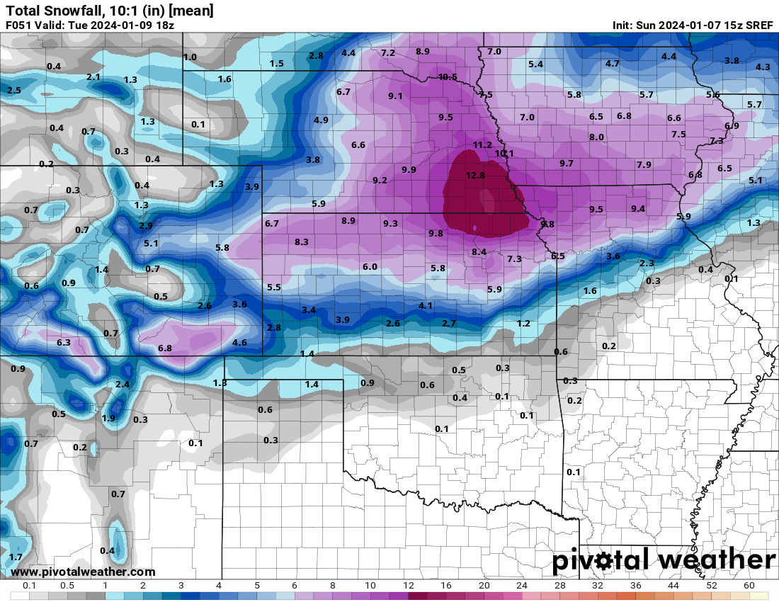
Pretty good increase around here. -
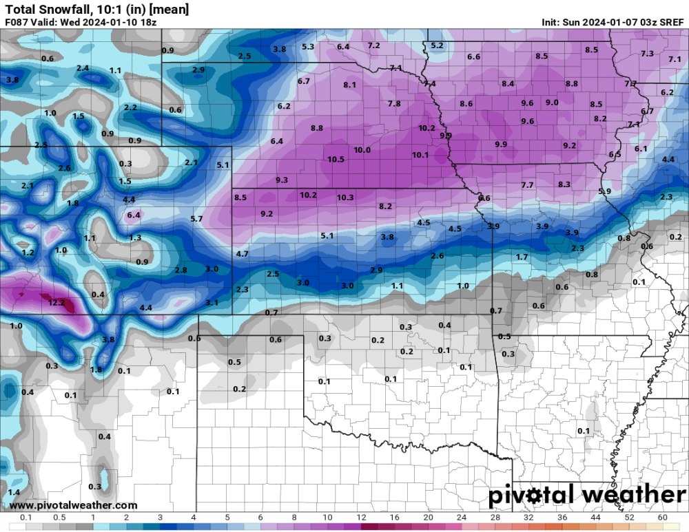
15z SREF 10:1 ratio

-
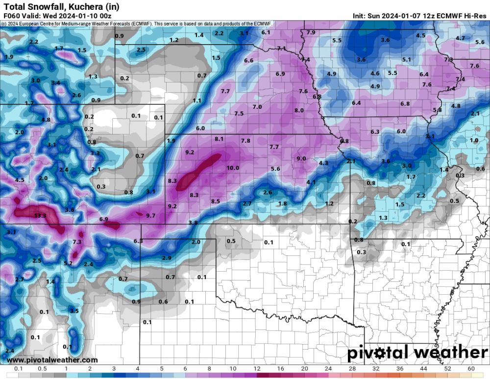
12 Euro Kuchera
-
NWS Hastings mentioned in its forecast zone, that the southern counties will be tricky with thermal issues and where does the dry air punch into. I’m sure that will be the issue on the southern side of the storm as a whole. Good luck.
-
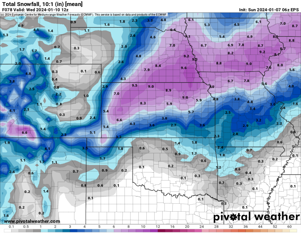
06z EPS
-
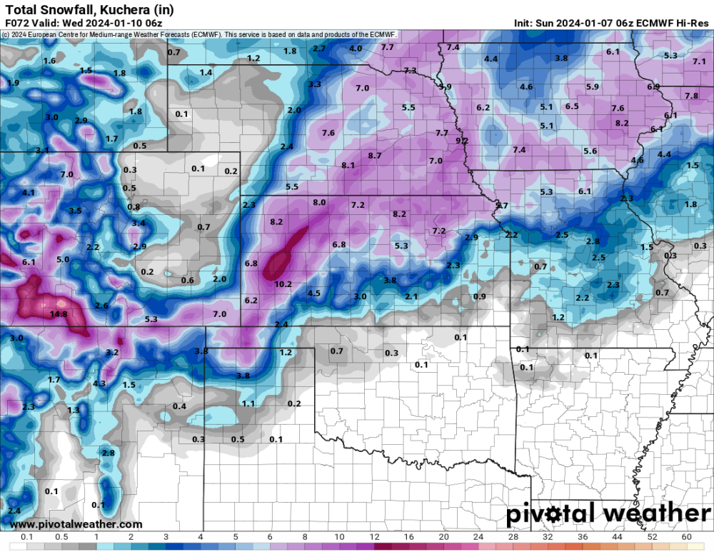
06z Euro
-
NWS Hastings morning disco Models have had a western shift with the primary deformation snow band, which could be nearly stationary for a time on Monday and combine with other factors to produce brief bouts of heavy snow rates. - Slight uptick in wind gust potential Monday night. Still think most areas will gust in the 30-40 MPH range, but especially W/SW of the Tri-Cities could gust up to 45 MPH. Nrly gusts 35-45 MPH) from W to E, as early as mid-late aftn W of Hwy 283, then elsewhere Mon evening. This will coincide with falling temperatures and increasingly "dry" nature to snow. This will really ramp up the blowing and drifting factor and possibly lead to near- blizzard conditions, especially in open areas, Mon night. Travel on W-E roads, including I-80, could be particularly difficult. Falling snow will end by dawn Tue AM, but winds will be slow to decr...so difficult travel will likely persist into/through the Tue AM commute.
-
-
03z SEEF 10:1 ratio