


snow_wizard
-
Posts
41072 -
Joined
-
Last visited
-
Days Won
40
Everything posted by snow_wizard
-
 You beat me to it. Simply amazing. The Canadian is just as good or even better. The ECMWF ensemble has been dead nuts on with this thing for a long time now. Very high chance we are still cold when Jan 10 rolls around. We are seeing the ECMWF operational exhibit the exact same error it did about a week ago. This ensemble mean has snow written all over it.
 -
SEA was colder than those places in January 1950. Later on this event could take on a pretty strong N to S temperature gradient.
-
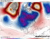
To me it almost looks like the ECMWF is back to it's old trick of putting too much emphasis on the southern branch / cutoff low again in the day 9 to day 10 period. As you will remember it (and to a lesser extent the GFS) showed that about a week ago for New Years / early next week also. Ensembles are the way to go right now beyond day 7.
-
I like seeing the second dip showing up on the GFS ensemble again. That one takes us back down to -10 or -11. Going to be a ridiculously cold first week of January.
-
My thoughts for the night. 1. Central Puget Sound sees widespread 1 to 3 inch accumulations New Year's Eve with some place getting 4 or 5 inches. I think the operational model has a better handle on the precip than the WRF. 2. Temperature forecasts for early next week will need to be pruned by about 5 degrees. A couple of days should fail to reach 30...especially if there is snow on the ground. 3. The ensembles continue to look outstanding deep into week 2. This is especially true on the latest GEM ensemble which is incredible tonight. 4. Still a high chance of a major snow event in the 10 to 15 day period.
-
I can't believe this could be the first REAL January in nearly 50 years. I'm stoked!
-
Can't wait to see the WRF. Weatherbell maps shows 4 inches for this area over the weekend.
-
The block is still there to suppress the pattern so it could tack south of us. This could get insane. A lot of solutions showing historic potential.
-
Wow! After all of that the block is still there at day 16. Hard to not be a bit excited.
-
That is top tier stuff right there. It would be up there with anything we've ever recorded.
-
It's normal to have a brief warm interlude during these things. Usually snow on both sides of it.
-
Some hint some PV action could get close to us later on. Could be wild! Another thing I'm noticing is pressure gradients get really weak after the Arctic air mass moves in. We are going to achieve full radiational cooling.
-
Possible snowmeggedon scenario later in the run. Huge potential in the 10 to 15 day period.
-
I think the block is almost like a black hole. It just sucks everything into it and adds to its size.
-
About the most beautiful and stable block you can ever hope for around day 8.
-
This might call for champagne and a nice Cuban cigar.
-
I'm lost.
-
Yup. I think the crucial moment in the evolution of this was right in the warm bias window last night. It just threw the whole run off.
-
I can't believe we can actually have fair confidence we will have snow going into this event. If tonight's Euro is the same I will be pretty confident.
-
Fantastic looking run for phase 1.
-
Dream scenario for us with an Arctic front. Love seeing that surface low center over the southern half of Eastern WA. I also like seeing how squashed the area of low pressure is. We do well in cases like this.
-
The two coldest days in Seattle were 1/31 - 22/3 2/1 - 25/4 The next coldest low in the city was 11 in Jan 1907 and Jan 1950. There was an unofficial -6 recorded at Woodland Park (North Seattle). Supposedly recorded by Arthur Denny who was noted for being very accurate about such things. Unofficial -15 recorded somewhere near Mount Vernon. The Fraser River was reported to have been frozen solidly all the way across. Numerous cold related problems were reported in Seattle.
-
I thought about that one. It was a pretty lame month for the Seattle area though. Kind of interesting you could also add 1911 for Whatcom County. Very disproportionately cold up there that month.
-
Just a quick list of great Januaries....ones that featured at least half the month being very cold and in most cases snowy. 1854 1862 1868 1875 1888 1890 1893 (was only cold late, but possibly the coldest air mass to strike this area in the 1850 to present period) 1907 1909 1916 1929 1930 1937 1943 1949 1950 1957 1963 1969 They just kind of stopped there although 1980 came kind of close.
-
Most models show some big time stuff in the 10 to 15 day period. ECMWF ensemble says block is still in place at day 15. That thing is looking epic.

