


snow_wizard
-
Posts
41089 -
Joined
-
Last visited
-
Days Won
40
Everything posted by snow_wizard
-

February Weather in the Pacific Northwest
snow_wizard replied to Deweydog's topic in West of the Rockies
The WRF shows the C-Zone sinking at least this far south. I sure hope so! -
February Weather in the Pacific Northwest
snow_wizard replied to Deweydog's topic in West of the Rockies
Too early to worry about that yet. -
February Weather in the Pacific Northwest
snow_wizard replied to Deweydog's topic in West of the Rockies
It's going to be interesting to see how the late week stuff plays out. Closed ULL scenarios are always full of surprises. -
February Weather in the Pacific Northwest
snow_wizard replied to Deweydog's topic in West of the Rockies
The radar shows ev the showers over the ocean are turning to snow now. I think the NWS is a bit too warm with thier expectation given a lot of the inland stuff is going to snow already as well. -
February Weather in the Pacific Northwest
snow_wizard replied to Deweydog's topic in West of the Rockies
A very interesting thing about the pattern late week is the surface gradients go dead flat which will allow the cold air to just kind of sit here. This has big potential, but we have a way to go. -
February Weather in the Pacific Northwest
snow_wizard replied to Deweydog's topic in West of the Rockies
Here is the 24 hour snowfall for Friday. Nothing huge, but nice to see.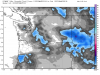
-
February Weather in the Pacific Northwest
snow_wizard replied to Deweydog's topic in West of the Rockies
The pattern being depicted late week is so different than anything so far this winter, maybe it will be the shakeup needed for Seattle to score. -
February Weather in the Pacific Northwest
snow_wizard replied to Deweydog's topic in West of the Rockies
The ECMWF has lowland snow Friday morning with mid morning temps only in the low to mid 30s. Not too D**n shabby. -
February Weather in the Pacific Northwest
snow_wizard replied to Deweydog's topic in West of the Rockies
The ECMWF has a decent look to it at day 5. Trough closer to the coast like the other models. -
February Weather in the Pacific Northwest
snow_wizard replied to Deweydog's topic in West of the Rockies
It shows up more on the general precip map. -
February Weather in the Pacific Northwest
snow_wizard replied to Deweydog's topic in West of the Rockies
It's there, but the details on how it will play out, how long it may last, etc aren't that clear. -
February Weather in the Pacific Northwest
snow_wizard replied to Deweydog's topic in West of the Rockies
Looks like SEA ended up at -10.5 for the week. That is big league cold for this time of year. -
February Weather in the Pacific Northwest
snow_wizard replied to Deweydog's topic in West of the Rockies
It's going to be fun to run the numbers on this cold snap vs prior ones in this time frame. The one week and two week average temps could be pretty eye popping. Many places were right around -10 for this week. -
February Weather in the Pacific Northwest
snow_wizard replied to Deweydog's topic in West of the Rockies
It is. More chances for the right combo to finally come up for Seattle. -
February Weather in the Pacific Northwest
snow_wizard replied to Deweydog's topic in West of the Rockies
The ICON shows some Fraser outflow commencing later in the week now also. The surface high complex has a much more favorable look to it vs previous runs. This cold episode doesn't want to die. -
February Weather in the Pacific Northwest
snow_wizard replied to Deweydog's topic in West of the Rockies
Tuesday morning is a go on the WRF. Shows an inch or so for many areas. -
February Weather in the Pacific Northwest
snow_wizard replied to Deweydog's topic in West of the Rockies
Totally amazing! The GFS and ensemble have made a decidedly colder turn for late next week. The trough digs closer to the coast than previous runs. -
February Weather in the Pacific Northwest
snow_wizard replied to Deweydog's topic in West of the Rockies
But this time we are cold at the same time they are. No question things have evolved since 2005....thank God! -
February Weather in the Pacific Northwest
snow_wizard replied to Deweydog's topic in West of the Rockies
Yup. Really hard to imagine missing a likely shot like that. -
February Weather in the Pacific Northwest
snow_wizard replied to Deweydog's topic in West of the Rockies
I noticed that. They have done very well with this event though...especially considering the cold all came from the north. -
February Weather in the Pacific Northwest
snow_wizard replied to Deweydog's topic in West of the Rockies
We'll see. It's pretty easy to get snow in March with cold convective showers. Snow in March is actually reasonably common, just not the big long lasting type. -
February Weather in the Pacific Northwest
snow_wizard replied to Deweydog's topic in West of the Rockies
Interesting. Somehow in the midst of all this I missed a very legit snow chance Tuesday morning. The NWS is actually going for a one word forecast for the EPSL Tuesday morning...Snow. Looks like water EQ will only be good for a half inch to an inch though. -
February Weather in the Pacific Northwest
snow_wizard replied to Deweydog's topic in West of the Rockies
Even though the temp rose to 43 here today it was still well below normal. The next 3 days look to be decently chilly with a couple of solidly cold nights. Probably 20s for many places again. -
February Weather in the Pacific Northwest
snow_wizard replied to Deweydog's topic in West of the Rockies
Truth be known sometimes the model riding is as fun as an event actually happening...well almost. If January could have delivered something this would have been a really solid winter for most of us. As it is, I can live with it at least. This cold snap has really been something for this time of year. -
February Weather in the Pacific Northwest
snow_wizard replied to Deweydog's topic in West of the Rockies
That is one of the most awful things about this climate. Watching places less than 10 miles away get nailed when you get nothing. As I always say though...it always evens out. I can say with utter certainty the overall screwing of the Central Puget Sound region will end and people elsewhere will be envious of us. Just goes with the territory. I hear you loud and clear about simply looking at the models, radar, whatever for yourself and not getting caught up in the moodiness of this place sometimes.

