

GHweatherChris
-
Posts
14141 -
Joined
-
Last visited
-
Days Won
20
Everything posted by GHweatherChris
-

January 2024 Weather in the PNW (Part II)
GHweatherChris replied to Meatyorologist's topic in West of the Rockies
Temp still 36 here, this is fun..... -
January 2024 Weather in the PNW (Part II)
GHweatherChris replied to Meatyorologist's topic in West of the Rockies
Radar showing evidence that the boundary has crossed the north central coast of Washington, small cells popping up over the water now. -
January 2024 Weather in the PNW (Part II)
GHweatherChris replied to Meatyorologist's topic in West of the Rockies
My money is on a decent deformation band up this way on Saturday, early in the progression on the GEM and GFS there is alot of northern precip shown over the ocean, I am an amateur and don't know what I am saying but decent chance is there. -
January 2024 Weather in the PNW (Part II)
GHweatherChris replied to Meatyorologist's topic in West of the Rockies
I guess since snow is out of the question I was hoping for a flash freeze, instead it will just be a typical night of low 20's eventually, already had a couple of those this winter without arctic influence. -
January 2024 Weather in the PNW (Part II)
GHweatherChris replied to Meatyorologist's topic in West of the Rockies
NWS says it gets down to 22 here tonight, I don't think so.... -
January 2024 Weather in the PNW (Part II)
GHweatherChris replied to Meatyorologist's topic in West of the Rockies
Temp bounced up to 36, is it cummming...... -
January 2024 Weather in the PNW (Part II)
GHweatherChris replied to Meatyorologist's topic in West of the Rockies
The green frog monster is trying to get to Neah Bay for some reason....
-
January 2024 Weather in the PNW (Part II)
GHweatherChris replied to Meatyorologist's topic in West of the Rockies
Wind has definitely shifted here, went outside without a shirt on to confirm. But, temp still stuck at 35. -
January 2024 Weather in the PNW (Part II)
GHweatherChris replied to Meatyorologist's topic in West of the Rockies
Temp has held steady here at 35 for the last 2 1/2 hours.... -
January 2024 Weather in the PNW (Part II)
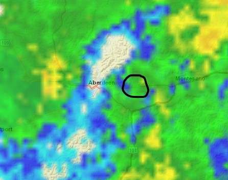
GHweatherChris replied to Meatyorologist's topic in West of the Rockies
The circled is new cells in the last 10 minutes, hoping that type of activity expands west and then continue NW flow....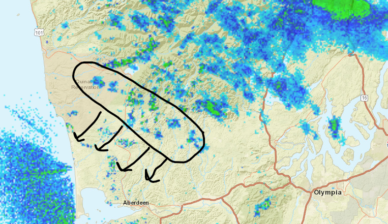
-
January 2024 Weather in the PNW (Part II)
GHweatherChris replied to Meatyorologist's topic in West of the Rockies
Hoping for some convergence off the SW side of the Olympics later this evening as the boundary gets closer to the Central Coast. Can see the precip over the Olympics causing that all of sudden zone off the hood canal. FYI, fully aware the models are not showing that scenario for it and I do not need a map showing that it isn't, hoping for the best. -
January 2024 Weather in the PNW (Part II)
GHweatherChris replied to Meatyorologist's topic in West of the Rockies
I know how to check dew points.... I am talking about updated one with the front position on the map itself, someone posted it earlier. -
January 2024 Weather in the PNW (Part II)
GHweatherChris replied to Meatyorologist's topic in West of the Rockies
Does anyone have an updated image of where the boundary is currently draping? -
January 2024 Weather in the PNW (Part II)
GHweatherChris replied to Meatyorologist's topic in West of the Rockies
35 and light snow here. -
January 2024 Weather in the PNW (Part II)
GHweatherChris replied to Meatyorologist's topic in West of the Rockies
Post em without commentary. -
January 2024 Weather in the PNW (Part II)
GHweatherChris replied to Meatyorologist's topic in West of the Rockies
DPs already dropping on the NW coast...
-
January 2024 Weather in the PNW (Part II)
GHweatherChris replied to Meatyorologist's topic in West of the Rockies
Trying to switch to all snow here, just a tad too warm to be impactful though. -
January 2024 Weather in the PNW (Part II)
GHweatherChris replied to Meatyorologist's topic in West of the Rockies
I will be wearing shorts as normal!! -
January 2024 Weather in the PNW (Part II)
GHweatherChris replied to Meatyorologist's topic in West of the Rockies
24.7 F -
January 2024 Weather in the PNW (Part II)
GHweatherChris replied to Meatyorologist's topic in West of the Rockies
I been putting the work in, Ronaldo is doing sit ups now to pull that moisture right on over us!! -
January 2024 Weather in the PNW (Part II)
GHweatherChris replied to Meatyorologist's topic in West of the Rockies
Saturday gonna be fun!! -
January 2024 Weather in the PNW (Part II)
GHweatherChris replied to Meatyorologist's topic in West of the Rockies
I think there will be a chance of some convergence coming around the southern Olympics to enhance precip as the boundary approaches, it has happened before here and not been picked up in the models. Can't remember what year the last one was but models showed maybe 1/2" here, ended up with 9+ with moisture constantly backfilling and cold air flowed in. -
January 2024 Weather in the PNW (Part II)
GHweatherChris replied to Meatyorologist's topic in West of the Rockies
It's gonna be deformation Saturday up here!! -
January 2024 Weather in the PNW (Part II)
GHweatherChris replied to Meatyorologist's topic in West of the Rockies
There ya go


