

epiceast
-
Posts
1531 -
Joined
-
Last visited
-
Days Won
1
Everything posted by epiceast
-
March 2019 Weather Discussion in the PNW
epiceast replied to BLI snowman's topic in West of the Rockies
So another phantom storm for PDX is the consensus here? Or a real deal? -
3' mark will probably be crossed given more warm fronts that will be coming in.
-
February 2019 Weather Observations and Discussion Part 2
epiceast replied to snow_wizard's topic in West of the Rockies
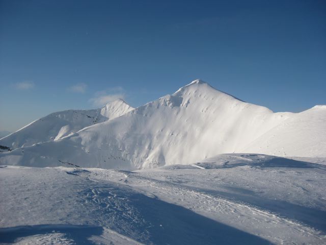
Decided to take a peak at bend subreddit, here is the best picture I found. Maybe I'll get there in the first week of march if we get a big overrunner before the warm up. Picture taken by u/pojodan -
February 2019 Weather Observations and Discussion Part 2
epiceast replied to snow_wizard's topic in West of the Rockies
Overweighing the radar data(seems like no return area about to move over PDX). but 700mb levels and RH tell a different story, favorable environment for another 3 hours so it might back build. I doubt you would get the heaviest returns with the flow shift however. -
February 2019 Weather Observations and Discussion Part 2
epiceast replied to snow_wizard's topic in West of the Rockies
Any chance of making it all time for King? Like somewhat reliably and fairly recorded, with more than 1 fort location in each county recording snow. I still think Clallam and Yakima are the biggest winners relative to average/median. -
February 2019 Weather Observations and Discussion Part 2
epiceast replied to snow_wizard's topic in West of the Rockies
Is this the first standard winter storm we're actually getting? Seems like some warm fronty action to me where the surface low is somewhat decoupled from the upper levels that are nearly southern, instead of a trough digging past the cascades or a jet stream pinching the block. -
February 2019 Weather Observations and Discussion Part 2
epiceast replied to snow_wizard's topic in West of the Rockies
Yeah the scences in deschutes and Yakima county(earlier) are Definitely have a shot at record February snowfalls for a few counties in Washington: Benton, Franklin, Yakima(absolute bulls eye epr this map, 3' below 1000' in unfavored locations for sure by the end of the month) maybe even Asotin and Walla Walla. Deschutes the Oregon bullseye of the event probably also has a shot at known records for the month. Clallam west of the cascades(correct me if I'm wrong). Maybe i'm missing a county or two. -
February 2019 Weather Observations and Discussion Part 2
epiceast replied to snow_wizard's topic in West of the Rockies
No comment necessary. -
https://nwschat.weather.gov/p.php?pid=201902261936-KMSO-NOUS45-PNSMSO Updated totals by Missoula NWS
-
http://theweatherforums.com/index.php/topic/1976-february-2019-weather-observations-and-discussion-part-2/?p=449550
-
February 2019 Weather Observations and Discussion Part 2
epiceast replied to snow_wizard's topic in West of the Rockies
Anyway since Kayla posted her Bozeman pictures I think I'm allowed to post a couple Missoula pictures since it's actually in the PNW and we're having a boring day today. First picture is backyard, 18-20" stumps and abandoned bbq chairs for reference. Second picture has drifts in the lee of my house, not as impressive here as there are closer to campus/Hellgate canyon which got more windy over the last 2 weeks, there are definitley 3' and maybe even 4' drifts there without human assistance.

-
February 2019 Weather Observations and Discussion Part 2
epiceast replied to snow_wizard's topic in West of the Rockies
I though the cold helped with a negative departure, not the other way around??? -
February 2019 Weather Observations and Discussion Part 2
epiceast replied to snow_wizard's topic in West of the Rockies
Kennewick data for the month. It's a snowy month... that .5" with no snow is a windy day that this station didn't record properly
-
February 2019 Weather Observations and Discussion Part 2
epiceast replied to snow_wizard's topic in West of the Rockies
2016-2017 winter was also an epic one with foot+ snow depths observed in the columbia basin from a bunch of smaller storms in December-January. Once in a 100 year event for large swaths of the basin, maybe once in a thousand year for select few. -
February 2019 Weather Observations and Discussion Part 2
epiceast replied to snow_wizard's topic in West of the Rockies
I bet a lot of places in Richland and Kennewick are over 2' mark now. -
February 2019 Weather Observations and Discussion Part 2
epiceast replied to snow_wizard's topic in West of the Rockies
When I think snow sublimation, Montana and Minnesota come to mind, not North Bend. Also it would likely stay crusty until the early afternoon if the dewpoints. -
UM is open, and is actually probably the only institution open in town today! Mall closed at 6pm last night, airport is closed, all the forest service offices are closed as well. Main roads are in good conditions here for sure, but people not owning a SUV/Truck for clearance could be immobile for a few hours today if they live near the Hellgate canyon outflow.
-
10" storm total 8" new. Missoula airport exceeded 15" and was tied or ahead of Bozeman airport as far as snow totals go for a few hours early this morning. I wonder if any benches on north side of a hill in the Bitterroot exceeded your snowfall with 2' dump across many places.
-
February 2019 Weather Observations and Discussion Part 2
epiceast replied to snow_wizard's topic in West of the Rockies
Doesn't your snow already have a crust on it, so all of that is moot? -
February 2019 Weather Observations and Discussion Part 2
epiceast replied to snow_wizard's topic in West of the Rockies
Silverton Tim -
February 2019 Weather Observations and Discussion Part 2
epiceast replied to snow_wizard's topic in West of the Rockies
Another storm about to rollin as well. Could clinch it. -
https://www.weather.gov/source/crh/snowmap.html?zoom=8&lat=46.3&lon=-113.5&hr=24 Probably at a foot here now after the strong band came through a couple hours ago(4 to 5 new since dusk). Was impossible to measure earlier on our valley. I don't know how they managed to measure 6" at 5pm, 2 to 3 at most fair spots(bare sidewalks that didn't get windload drifts) here but it was snowing at half a mile visibility with 30mph winds for most of the day so it sounds about right. Impressive totals for the Bitterroot where it snowed all last night. Definitely a "storm king" type of track for the 'root valley @ 850 mb levels.
-
Could be, last night 700mb temps were much colder before the trough came on shore. I'm seeing a lot of 1:30 to 1:50(Butte/Anaconda area) reports around here in western montana too, but I don't buy them because of the wind however, i think it's just under measuring the qpf in a lot of cases by maybe even a factor of 2. takes some extreme atmosphere conditions to exceed 1:30
-
February 2019 Weather Observations and Discussion Part 2
epiceast replied to snow_wizard's topic in West of the Rockies
A++++ material Jesse -
Yeah definitely more moisture today. I think bigger flakes = wetter snow, and lower ratios though. Haven't really noticed much of a difference here between yesterday's this morning's and afternoon's snow, it's all light(better than 12:1) enough to get blown around and mixes together on places where i shoveled. But I see lost trail pass is up to 26, so the warm nose is definitely trying to push past id/ca border even in near surface levels...


