


Phil
-
Posts
44584 -
Joined
-
Last visited
-
Days Won
262
Posts posted by Phil
-
-
Welp I have full blown pink eye, complete with photophobia. Because, of f**king course.
 I have to be living in a simulation bc this is scripted too perfectly.
Needless to say, no eclipse travel for me. I’ll have to enjoy my 90% view from here, with one functioning eye (barring a last second miracle).
-
 1
1
-
 3
3
-
 1
1
-
 1
1
-
 1
1
-
-
1 hour ago, TT-SEA said:
First it looked ridgy... then it looked like it troughing would be focused to the north... and now the models have come around to more of the same with that system diving down to SoCal next weekend. Crazy model swings the last few days.
Tbh I’m not sure what it is about this particular pattern that is tripping guidance up. This kind of instability isn’t unusual for the GFS/GEFS, but the EPS and GEPS also got thrown for a loop.
I had suspected something was wrong with those crazy ridgy solutions only because it wouldn’t fit the models’ own MJO projection(s) (not even secondary EOFs). But I’m at a loss as to why there was/is such a disconnect in the first place.
1 hour ago, TT-SEA said:Spreads rainfall around... pretty important for balancing things out.
El Niño releases stored heat too. A lot of it.
La Niña stores heat. She is the antagonist, hiding her true intent by cooling the atmosphere.
58 minutes ago, SnarkyGoblin said:Another depressing statistic. 38.5 degress Celsius above their normal for the day. Imagine if that were to happen anywhere else in the world.
That article is pure hype/spin. Such anomalies are not unheard of in the Antarctic (especially the WAS area). Only difference is time of year, in this case.
-
 5
5
-
 1
1
-
-
1 minute ago, MossMan said:
At least we are not facing another stupid El Niño the next go around.
El Niño is proof god exists and there is justice in this universe.
-
1
-
1
-
-
Quite the shift on the GEFS for next weekend.
-
2
-
1
-
 2
2
-
1
-
 1
1
-
-
3 hours ago, Deweydog said:
Thought there were some flakes mixing in but then realized it was cherry blossom petals.

I feel u.
-
1
-
-
11 minutes ago, Omegaraptor said:
Most western troughs the last couple months have been mainly CA/SW focused, I've noticed next weekend is mainly north-focused. Other shoe's gotta drop eventually I guess.
That should become less frequent with time as the niño elements attenuate.
-
2 minutes ago, SilverFallsAndrew said:
But will it snow at my house?
I predict it will snow at your house in 7-8 months.
Maybe a 5% chance for conversational flakes/graupel in early May?
-
2
-
-
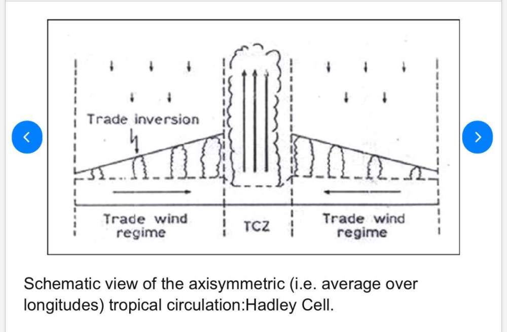
50 minutes ago, TT-SEA said:
Totally agree. I was enjoying my coffee and commented to my wife on the axisymmetric dissociation in the LF state in tropical convection.
Here’s a visual aid re: example of axisymmetry applied in meteorology.
Technically the correct term for what I was describing would be “mirror asymmetry”, but that’s not how it’s phrased in meteorology, and would have sounded even more jargony.

-
9 minutes ago, TT-SEA said:
Strange timing considering the ridge next weekend vanished and now the models show cold troughing instead.
Seems probable there will be at least a couple episodes of progressive ridging (nothing amplified/stationary) with the MJO propagating from the WPAC/warm pool through the W-Hem. I mentioned a few days ago that MJO-derived analog pools tended to fold over ridges after a few days, but none of those cases were troughy straight through (except volcanic years which aren’t viable analogs).
There is some axisymmetric dissociation in the LF state in tropical convection, largely related to the -PMM remaining post-niño (reduced off-equator NPAC +SSTA/OHC). Sample size for this type of setup is small and mostly outdated, so I’m hesitant to draw conclusions w/rt how it’ll project onto seasonal/subseasonal patterns. Might make zero difference for North America. But it’s possible this could introduce new structural uncertainties/error modes within guidance. We’ll see.
-
2
-
 2
2
-
 1
1
-
1
-
-
1 minute ago, Cascadia_Wx said:
Up to 77 now. It’s actually sort of interesting, and I don’t mind it too much since I know it’s normal for around here.
Looks like dews are in the low 60s there currently. I’d concur with you on that being a nice day (as long as it doesn’t happen in January or something).
-
1
-
-
6 hours ago, TigerWoodsLibido said:
Wonder how many 90F burgers we're gonna have this summer?
Fewer than me.
-
1
-
 1
1
-
-
Left my contacts in overnight now my right eye is having a b*tch fit. If this doesn’t clear up soon I won’t be able to drive.

-
1
-
4
-
 1
1
-
-
4 hours ago, Cascadia_Wx said:
Looked out the hotel window this morning, and immediately thought of Phil. Currently 64 and houmid in Houston.

At least 64 and humid still feels “cool”.
-
1
-
 1
1
-
1
-
-
3 minutes ago, MossMan said:

You heat misers are such sadists.

-
1
-
1
-
1
-
1
-
-
1 hour ago, Phishy Wx said:
end of days
New Euro monthlies come close.
Continent-wide death torch. Tim-tastic.

-
1
-
1
-
3
-
 1
1
-
 1
1
-
1
-
-
2 hours ago, Phishy Wx said:
East Coast struggling with what Graupel is
Most CWG commentators aren’t wx geeks like us.

FWIW I didn’t even see graupel today. Just a gusty rain shower sandwiched between periods of sunshine.
-
2
-
-
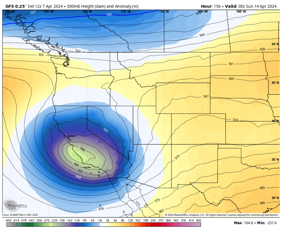
In fact the 12z ECMWF has like 2 warmish days before its gets knocked down again. If anything it’s the cool departures that are the most anomalous (especially in the SW/Intermountain West).
-
3
-
1
-
1
-
1
-
-
Looks like the Euro/EPS have backed off the mega-ridge solution.
More in line with other guidance now (garden variety ridge that lasts several days to a week before folding over). I don’t think this particular situation warrants substantial concern ( @Cascadia_Wx).
-
1
-
1
-
1
-
-
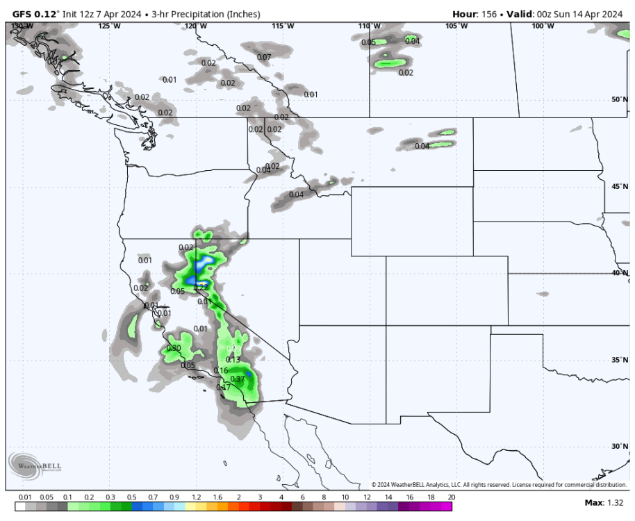
OTish, but fr I forgot how much trees love prolonged 50°F rain in the spring. It’s been so long since it last occurred I half-forgot it’s actually climo.
Everything is erupting with green, much denser and healthier than last year when it barely rained. Hope it continues.
-
1
-
-
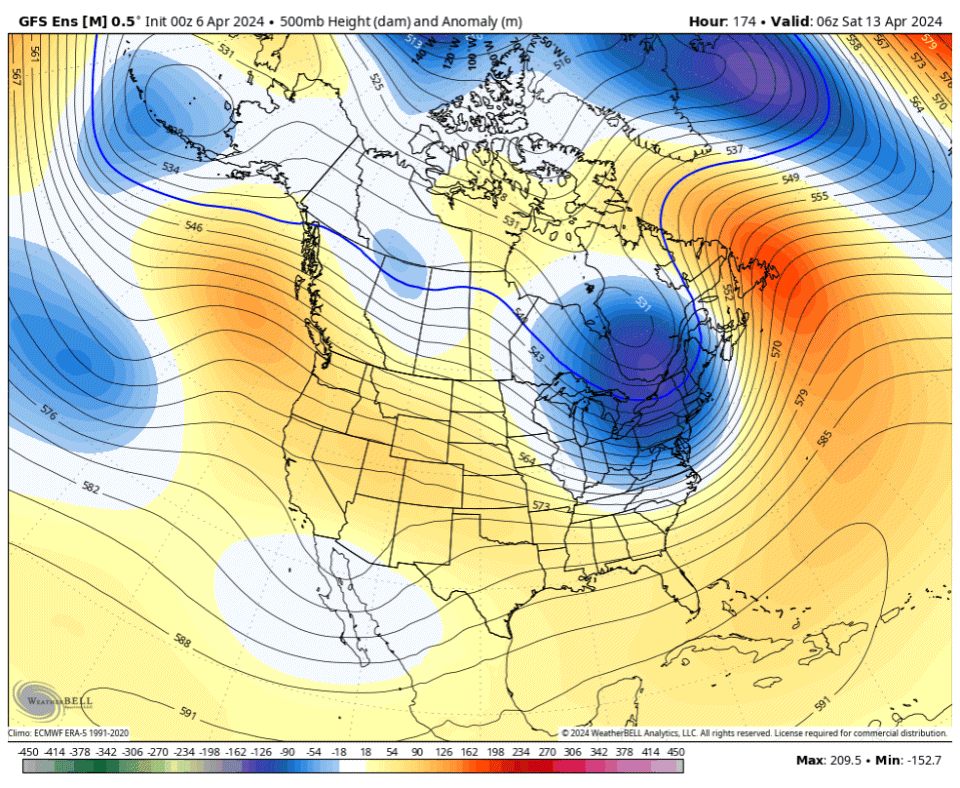
Interesting how the operational Euro and ~ 50% of EPS members handle next week’s MJO & RWB differently than all other guidance. Leads to an entirely different progression of the NPI and NAM.
Curious to see what ultimately happens.
-
1
-
-
5 hours ago, Timmy Supercell said:
Ashland had the outflow winds and scattered outages/trees down but I don't think this town had a tornado. I have power but most of Ashland reportedly doesn't have internet. Been stuck using a potato Android phone for all of my information.
It was a big storm. Couldn't make out a lot of structure but it looked like some kind of wall cloud may have formed. But shelf wasn't very clearly there. Video was hard to get and it's a good thing I wasn't standing on our deck because a few objects did fly by right where I would've stood.. Lol
Glad you’re ok brother! You had me worried haha, usually you’re on here posting immediately after a big storm so I was worried you got hit by debris or something.
As stated previously, I suspect you’re in for a big league severe season, orders of magnitude above the mediocrity of the last 3 years in that region (meanwhile I’m probably in for a sub-par season, for the same reason). Hope u get some good video!
-
1
-
1
-
1
-
-
28 minutes ago, MossMan said:
It’s over
Not soon enough.
-
9 minutes ago, Cascadia_Wx said:
Not a lot of complaining here lately. And of course this is a little ironic coming from the guy who’s been complaining nonstop about phantom heat that hasn’t even happened yet

You mean in January when it was 81 degrees? I’m certain you would be complaining too.
-
1
-
1
-
1
-
-
2 hours ago, Cascadia_Wx said:
The general ridging the last six weeks has been way more significant than the spells of troughing in between. And it looks to stay that way.
Relatively speaking, I strongly disagree.
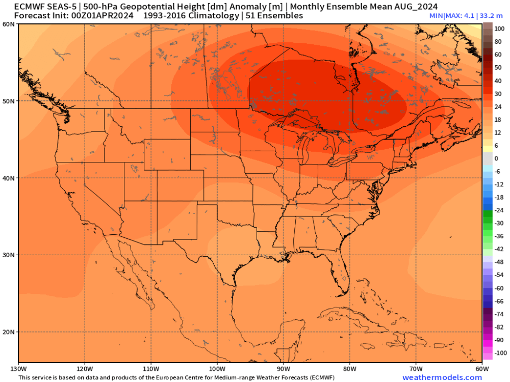
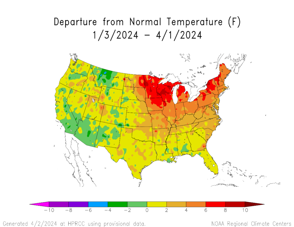
Cold air is lacking thanks to the niño base state, but the default trough position has been in the West. This is true when averaged over the last 30 days, 60 days, and 90 days.
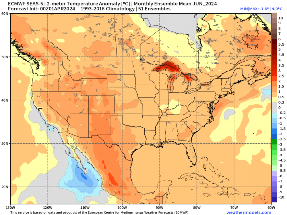
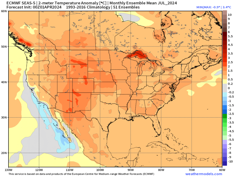
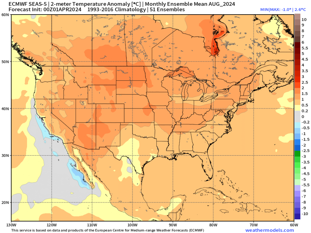
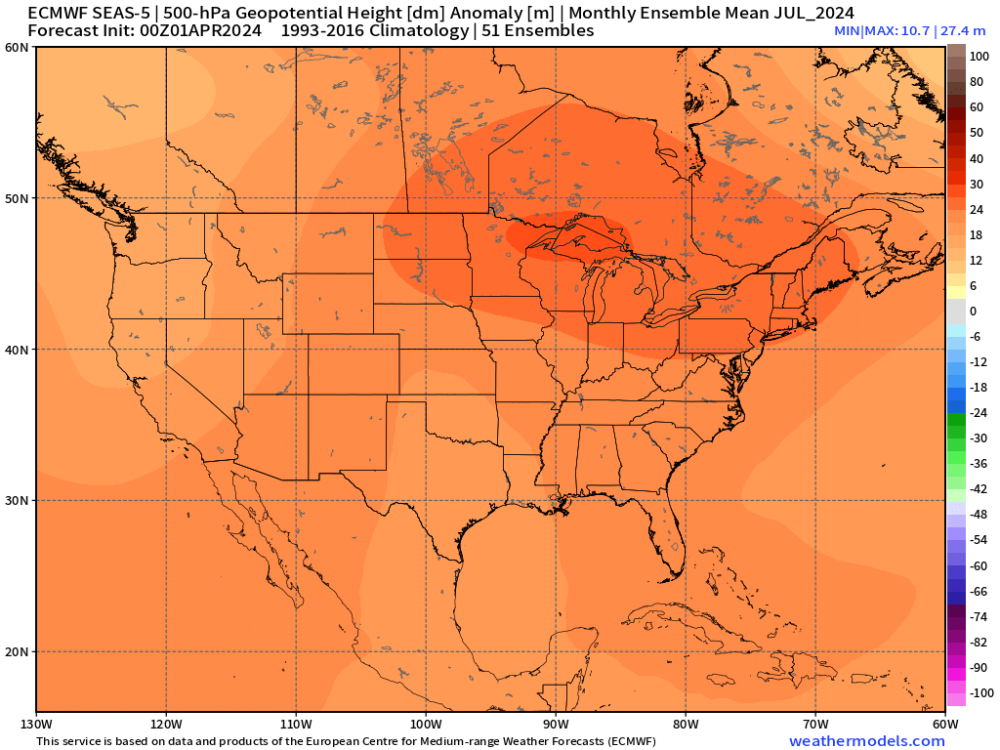
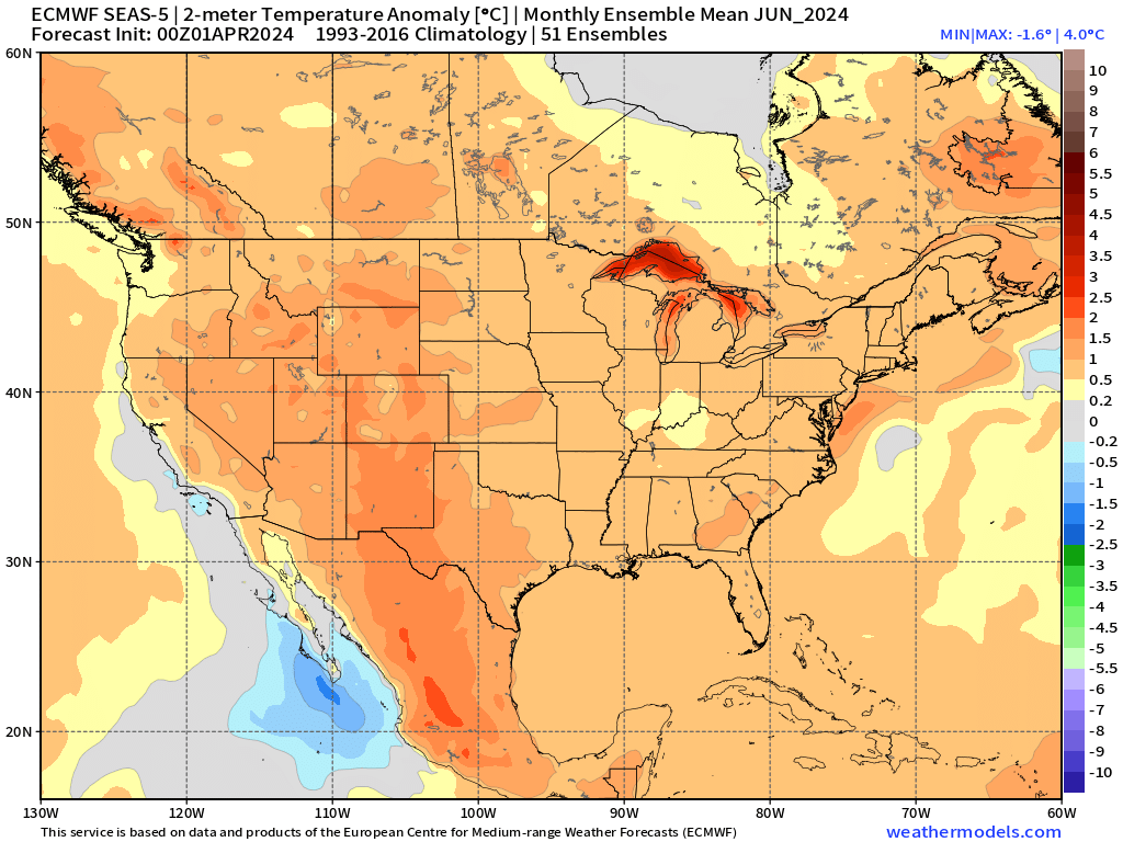
At some point the other shoe has to drop. And I highly doubt there will be much green/blue anywhere on this map as we head into summer. Torching looks like the rule for 90% of the CONUS through the remainder of 2024.
Just an awful, terrible, no-good-very-bad low frequency setup this year. And I think it will get substantially worse before it gets better.
-
1
-
1
-
 1
1
-


April 2024 Weather in the PNW
in West of the Rockies
Posted
At least I’ll have an opportunity to catch some of these, assuming I don’t go blind or bite the dust early.
2099 is probably off the table, though.