Phil
-
Posts
44541 -
Joined
-
Last visited
-
Days Won
262
Everything posted by Phil
-
Hell no. But when I was in grade school the day started at 7AM and ended at 2PM. Was pitch black walking to the bus stop during the winter. Life went on.
-
Might hit 80°F again today.
-
Yes you can. I did for years. Arizona is on permanent DST and somehow society hasn’t devolved into chaos despite sunrises after 8AM. And 9AM sunrises are fine by me if there’s more light in the evening.
-
Rightfully so.
-
Colorado? Bruh you’re nuts.
-
The sun doesn’t “stay out longer”. And people would simply run their A/C more earlier in the day. Out here we usually have to run it 24/7 so it doesn’t make a difference anyway. Standard time is shit and should be done away with entirely. Who the hell wants a 430AM sunrise? Or a 430pm sunset in the winter? Just stupid.
-
Okie dokie.
-
Paul Roundy’s LP composite is now projecting the central CONUS death ridge establishing from May onwards. North Central Plains and Midwest never get a break. Will probably be even larger in reality, smothering the entire continent below 50N. Heat misers will be thrilled. https://www.atmos.albany.edu/facstaff/roundy/waves/analogs/analogslp.html
-
Misery loves company. Maybe I’ll get lucky and score a ring of fire derecho or two before the death ridge shuts off convection for the rest of summer. Me and the gf are just going to drive out to OH and catch it somewhere random. Play it by ear.
-
Niño to niña summers are always atrocious out here if descending westerly shear (transition to +QBO) is also present/ongoing (2016, 2010, 1995, 1988, 1983, etc). I expect the worst. The niña transitions with descending easterly shear aren’t nearly as awful by comparison, but that combo is infrequent (only satellite era examples are 2007 and 1998).
-
Funny, 2015 was among the top-10 hottest summers on record here. Trough axis was slightly too far west so we were stuck with SW flow while the Ohio Valley scored cool departures. It was a warm summer nationally too, thanks to the obscene warm departures in the west. The larger scale pattern should be different this summer but not necessarily an improvement. Seems likely that a fat, ugly, sprawling ridge will set up in the center of the CONUS in July and stay put through September.
-
I think my timing has been lucky as well. Caught a weak trough when I was there last summer. Also in 2018 there was apparently a major smokefest that started a few days after I left. Was absolute perfection while I was there, but the pictures my family sent me afterwards might as well have been from another planet.
-
I thought your storm patterns involved offshore ULLs? Figured that would draw smoke in, if anything.
-
Continent-wide torching. You guys were the only cool spot. I don’t think it’s a guarantee that will be the case this summer. But I hope I’m wrong.
-
Thunderstorms didn’t save us from it last summer. Afternoon storms would clear the air for the evening, but next morning the gunk would be back full force. Every time.
-
I never really appreciated how you guys were suffering w/rt smoke until last summer. Major eye-opener. Hopefully that El Niño-forced hot/dry Canada pattern doesn’t recur this summer.
-
This summer is going to suck donkey balls. Fully expect it’ll be the hottest summer ever for the lower-48, and by a wide margin. Worst possible alignment of seasonal forcings. Good chance there won’t be any cool departures to speak of, except maybe June.
-
And good lord, we’re in for an apocalyptic hurricane season unless those Atlantic and west-IO SSTAs change dramatically, and soon.
-
Close match. Of course everything is warmer today. Biggest difference is the Indian Ocean/Indo-Pacific region. 2010 has the more classic pre-niña signature (warm IPWP) while 2024 is sort of doing its own thing.
-
Ugh.
-
Some of the 1950s niñas had a cool IO during their inception, but not sure about indo-pacific cooling (and the residual +IOD signature). IIRC, 1999 was the only modern niña with a clean +IOD signature during its developmental stages.
-
Large scale picture somewhat resembles 2010. +AMM/-PMM and descending westerly shear under waning strong niño.
-
That’s a mean-looking severe pattern east of the Mississippi.
-
Hardy har har. I’ve uploaded 1 video this yr and it was 15 secs.
-
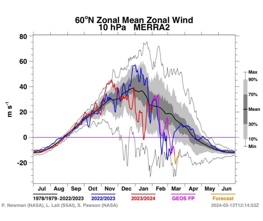
This is a legit multistep final warming. Just wish it could’ve happened a month earlier. PV started off strong in Nov/Dec but it became increasingly disheveled under +WAFz. Interesting evolution.