Phil
-
Posts
46006 -
Joined
-
Last visited
-
Days Won
275
Everything posted by Phil
-
Why can’t they share that with the rest of us? This is our driest 5/25 -7/2 in recorded history. Didn’t have a single thunderstorm in June. Have to go back to the 1930s to find anything remotely close. Hopefully this episode of western ridging will allow for some real convection. The next 10 days are so crucial.
-
Some of the high-res guidance has dews well into the 80s here after sundown on July 4th. Ooof. Would be unbearable for the fireworks show at the national mall. Will probably shoot off our own at my uncle’s place instead.
-
That would be more comfortable than a majority of days here thanks to those lows/dry air. That 101/63 afternoon on 6/22 was light years more tolerable than the 95/78 afternoon last week.
-
I read somewhere that PDX is one of the more prolific UHI afflicted stations in the lower-48 since the 1990s. I’ll have to dig up that analysis but it was quite thorough IIRC.
-
This is the correct take.
-
MRI for what? Must have missed some posts.
-
Did you uncheck the “show this post has been edited” box?
-
Operational ECMWF and EPS control run are substantially different over the NE-Pacific D8/9. Always a red flag for me w/rt internal consistency of the EPS suite.
-
You by yourself are close to matching the total number of whiny posts from the entire heat miser crew during the entire month of June. Difference is the heat hasn’t even started yet. You’re easily going to pass them.
-
FWIW the ECMWF has been overheating the boundary layer under deep ridges this year across the NH. Could be the GFS numbers are closer to reality for once. I’m not well versed in mesoscale climatology in other regions so I’ll leave that stuff to you guys. But the amplitude and magnitude of the ridge itself is not surprising to me.
-
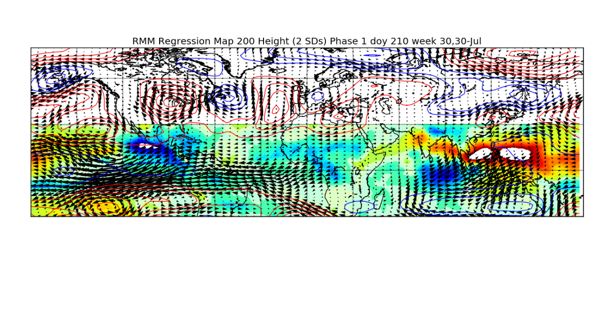
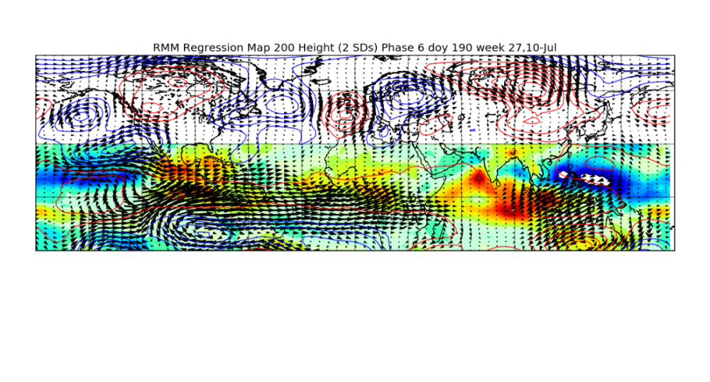
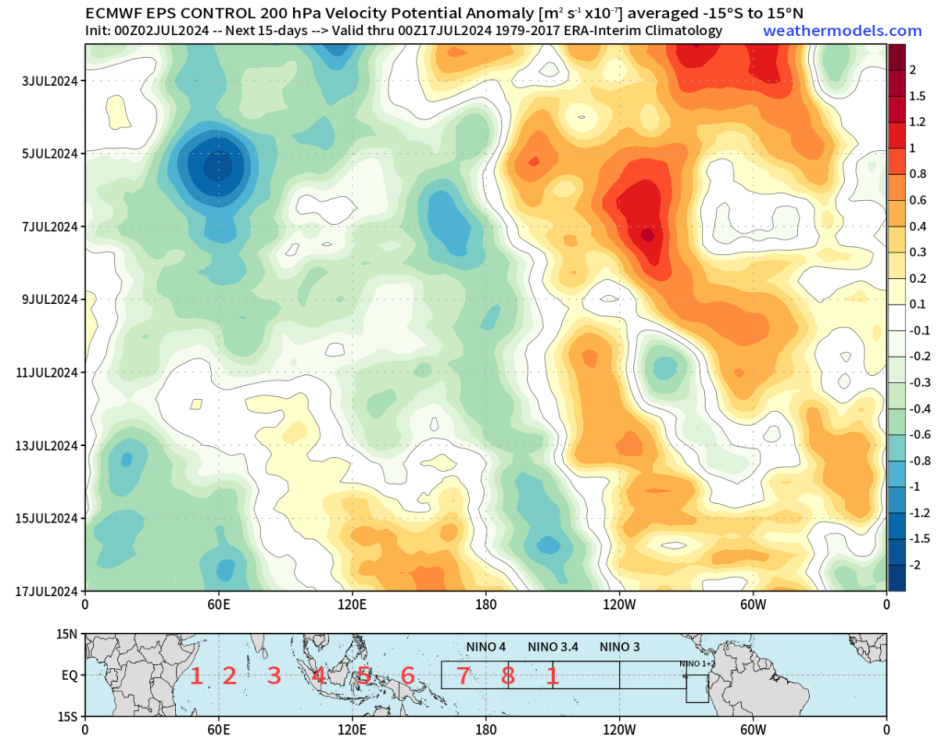
Here’s the climatological response to IPWP/WPAC MJO during the first 10 days of July. Low and behold, there is the +TNH/western ridge. By the last 10 days of July the MJO/CCKW will have propagated thru the W-Hem, into the W-IO (RMM phase-1). Lo and behold, the +TNH/western ridge is gone.

-
Do you realize how many attempts it took to pull off a fully realized +TNH response to a healthy IPWP MJO this year? The attempt in June failed. The one in May mostly failed. The one in February was mediocre at best. On one hand I’m trolled as a doomsayer for pointing out that tropical forcing favors a lower-48 blowtorch summer, then when it inevitably happens suddenly I’m downplaying it. Like…what? It’ll be ridgy for a week or so. Maybe a bit longer if all components align favorably for the heat misers. Then it will decay as tropical forcing becomes unfavorable to sustain the +TNH/+NPO wavetrain. *That* is a very typical subseasonal progression.
-
That post-2013 regime died last year. Subseasonal +TNH responses are still possible but it’s not reflective of the low frequency state anymore.
-
The heat hasn’t even started yet and will last maybe a week and you’re already falling apart. Did you expect there would be no ridgy periods this summer? None at all? Come on dude.
-
BLESSINGS.
-
Much cooler than the first half, but probably closer to average comparatively.
-
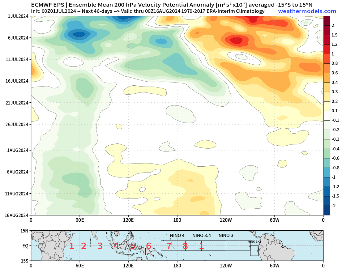
No worries, next +TNH cycle timed for 2nd half of August. Probably even more pronounced since climo ET response to any lingering IO forcing is warmer in the PNW vs July.
-
At least I’m not the only one suffering now.
-
Tropical forcing trending Jesse’s way 2nd half of July.


-
Interesting both ‘07 and ‘88 were post-niño years.
-
Beryl is a 165mph storm. WUT. Total Atlantic ACE will reach September levels by July 5th.
-
-
-
Should I spare you a Valium?
-
00z GFS kills the +TNH quickly. Probably too quickly.