


Phil
-
Posts
44502 -
Joined
-
Last visited
-
Days Won
262
Posts posted by Phil
-
-
3 hours ago, Frontal Snowsquall said:
“Heavy Drizzle” is just drizzle but with visibility of less than one-fourth of a mile.
3 hours ago, T-Town said:It’s like regular drizzle except lots of it at the same time.
3 hours ago, MossMan said:You get soaked instantly in a Heavy Drizzle event!
2 hours ago, Meatyorologist said:The other day we had sheets of heavy drizzle with wind. It's a once or twice a year thing, and while it looks really cool, almost like a blizzard, once you step outside you quickly realize it's more of a vibes type of event. Getting caught out in that is like turning your hose onto mist mode and letting it rip from three feet in front of your face.
1 hour ago, Chewbacca Defense said:I enjoy a good heavy drizzle, except if I am caught out in it unprepared (for the reason you mention). You don't hear the classic rainfall sound, just the sound of water dripping from the trees. Heavy drizzle while playing soccer is kinda lame, I have to wear glasses to play and I have a harder time with fogging and not being able to see through all the water on my lenses.
Conflicting reports?
Definitely have to check this one off my bucket list. I bet Tim gets a lot of heavy drizzle.
-
 1
1
-
-
1 minute ago, Cascadia_Wx said:
We were were having some storms. Definite Phil-pattern lately

Hey I didn’t use the J-word to describe the 12z EPS. Though I did consider it (because it’s true
") ).
).
-
 1
1
-
-
2 hours ago, Meatyorologist said:
Not to burst your bubble but in actuality the tightest pressure gradients and the mixing required to get those really strong gusts down to the surface both arrive after the front, in the postfrontal convective environment. Often where it's sunny and clear, albeit with bands of showers and thunderstorms. There are tight gradients that can make things a bit gusty ahead of the front as it approaches, but the stable air prevents much more than that. This actually means most of our windstorms, at least as I've observed here in the Puget Sound, come on nearly instantly. Given the tame nature of our climate it's a somewhat unsettling reminder of the vast amounts of thermal energy present in the Pacific, and how even our most boring weather is made possible by forces beyond our comprehension. Concentrate that energy release over a small area, and the sky is the limit, no pun intended.
49 minutes ago, Chewbacca Defense said:My experience is that *most* of the time, the strongest winds of a classic "PNW" windstorm hit with no rain, and typically a mid to high broken cloud deck. It's when we have a strong front pass through that we get the sideways rain and dark clouds, but that is usually pretty brief, maybe an hour tops.
Interesting, that’s kind of similar to here, then (w/rt the “instant” start time and lack of precip). Are the winds more sustained out there or are they more gusty?
Out this way the big league windstorms are driven by mountain waves and downsloping under post-frontal CAA/pressure rises. So winds usually manifest as strong, pulsing gusts that come in sets of 2-3 (except in exceptional events, which can rip nonstop, but that is uncommon).
-
 2
2
-
-
2 hours ago, Timmy Supercell said:
Looks like my dome is back, not one single rumble of thunder all day, but I see a report of a tree down in Ironton just a town over from me.
Seems when you score I get shafted and vice versa.
 I’ve been seeing flashes of lightning for the last 90 mins and there’s a bowing line of storms approaching from the southwest. Feels like an over-performer incoming.
-
1
-
 1
1
-
-
Here we go again. Shocker.

-
1
-
1
-
-
11 minutes ago, Phil said:
I’ve absolutely loved it every time I’ve visited. There’s a vibe I can’t quite put my finger on, but it’s deeper than just the conifers and distant terrain. I love it.
I haven’t spent any substantial amount of time there, so I can’t say how I’d feel after a year, but even if it’s not the best long term climate for me, I’ll wager that I would enjoy it for a time, at least. I’d be fascinated to learn/experience all the microclimates, mesoscale quirks, and different types of weather that I don’t get to experience here. I like learning, and I like trying new things.
For instance, most windstorms here are sunny or have a broken cloud deck. I’d love to experience a windstorm with dark clouds and precip like you get in the PNW, and I’d also be interested to hear how it sounds through the trees there (I assume the acoustics from a softwood forest are very different from a hardwood forest).
This is random but I’d also like to experience this so called “heavy drizzle” that you guys talk about. I can’t wrap my mind around what the heck that even is.
-
1
-
1
-
 1
1
-
1
-
-
27 minutes ago, iFred said:
Probably wouldn’t even appreciate the low sun angles, inversion season, the fun of a regional wind storm, or warm and clear summer twilight that lingers into a midnight darkness before breaking out into a beautiful shade of blue orange early the next morning.
I’ve absolutely loved it every time I’ve visited. There’s a vibe I can’t quite put my finger on, but it’s deeper than just the conifers and distant terrain. I love it.
I haven’t spent any substantial amount of time there, so I can’t say how I’d feel after a year, but even if it’s not the best long term climate for me, I’ll wager that I would enjoy it for a time, at least. I’d be fascinated to learn/experience all the microclimates, mesoscale quirks, and different types of weather that I don’t get to experience here. I like learning, and I like trying new things.
For instance, most windstorms here are sunny or have a broken cloud deck. I’d love to experience a windstorm with dark clouds and precip like you get in the PNW, and I’d also be interested to hear how it sounds through the trees there (I assume the acoustics from a softwood forest are very different from a hardwood forest).
-
6
-
-
38 minutes ago, Meatyorologist said:
Damn. I'll take your six consecutive days below freezing w/ 1-4" of snowcover and two lows of 11F. If that's so disappointing for you.
Let's just face it man. Your soul would shrivel up and die if you lived out here for even half a decade.
What use is cold if it’s not snowing? Thats like ice cream without sugar. Or a wedding without drinks.
Also, DCA doesn’t represent this area well due to UHI+river influence. It’s a very localized microclimate…one of the worst UHI bubbles in all of North America, in fact.
Here’s Dulles, for comparison. Difference in lows can be 20+ degrees in extreme cases. It’s wild.
-
1
-
-
38 minutes ago, Timmy Supercell said:
So far this one is nowhere near as wild as the last one at least on first impression.
I think the flooding from training storms, and a wind threat from a QLCS are the highlights. I would've opted for a Severe T'storm Watch for most of the areas in the TOR right now. Prove me wrong though!
Yeah lots of precip and crapvection in the warm sector ahead of strongest forcing.
But these high shear/low CAPE setups can overperform unexpectedly, and at the last possible minute. February 2016 and March 2008 looked like nothingburgers out here, but both ended up mixing out the low level inversion and producing QLCS’s with hurricane force winds and spinups.
-
2
-
-
34 minutes ago, TT-SEA said:
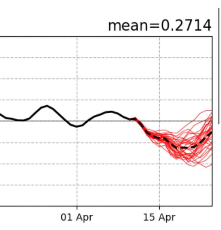
What does this summer look like in terms of 4CH?
The NPAC HC sector is actually very suppressed (and fast) thus far, but at least some of that is the residual niño component.
2021 and 2019 were easy calls because the tropical base state was stagnant in both cases. This year will (in all likelihood) feature a change in the base state over boreal summer/fall. So it’s difficult to know where things will stand once we lose the niño components of heat/mass exchange.
That being said, while very preliminary, the manner in which the background state of circulation is *evolving* appears much closer to transition years such as 2020 and 2010, and far removed from transitions like 1998 (or 2003, in the other direction). And definitely not following the -SPMM dominant Niña EOF we saw in 2017, 2021 or 2022 (or 1975, inversely). Though maybe next year will, if the niña refuses to die again.
-
1
-
 1
1
-
-
Speaking of tornadoes, I noticed @Timmy Supercell is under another watch.
Keep a watchful eye on this collision between the cold front and warm-sector thunderstorm outflow. 80% of the time nothing comes of it, but if something does, it’s a pretty dangerous environment.

-
1
-
1
-
-
12 minutes ago, BLI snowman said:
Sure, but tornado dynamics are actually a little more favorable the further north you go in FL. Given the better jet support and shear/helicity that exists in that corridor. Jacksonville is basically GA.
You are correct, but during the spring months there is often low level stability near the Atlantic Coast due to relatively cooler waters. Tornado and overall severe climo attenuates substantially within 30-40 miles of the Atlantic Coast in F/M/A (though in the summer/autumn the equation changes substantially, of course).
There are cases where that added differential heating can favor tornado formation, but for stronger tornadoes that is an inhibiting factor as they’re fueled by airmass and convective dynamics requiring significant boundary layer instability. It’s complicated/non-linear and not fully understood, but the evidence is pretty clear IMO.
-
3
-
-
2 minutes ago, Deweydog said:
ITCZ/HC FTW, IMO.
ITCZ = Intertropical Convergence Zone
https://en.m.wikipedia.org/wiki/Intertropical_Convergence_Zone
HC = Hadley Cell
-
1
-
-
6 minutes ago, BLI snowman said:
Tornadoes in FL really aren't that rare.
Yeah, they’re actually common, but they’re usually of the skinny/rope variety. Almost all are EF0 or EF1 (this one looks..beefier).
Thats what I meant. Basically the same story here, lots of little spin ups but rare to see EF3+. But even rarer in that part of FL.
-
2
-
-
54 minutes ago, DareDuck said:
Don’t know how you can predict that now. Lightning starts, offshore events in the fall, marine influence or lack thereof. All impossible to predict. Not to mention we’re a few weeks into spring. Not saying it will necessarily be a disaster, but this is even harder than predicting winter snowpack in early October.
Looks like a simple probabilistic forecast. Which would certainly be low confidence in this case, but “impossible” is a stretch.
In 2019 it was obvious early on that the 4CH would be suppressed with a flatter, more westerly upper level pattern in the PNW. That fire season was almost nonexistent as a result.
In 2021 it was the opposite, when it was clear by April that the 4CH would a massive beast (lots of off-eq convection, very wide ITCZ/HC).
-
1
-
-
Holy f***. Jacksonville FL? Their tornado climo is basically the same as ours, if not lesser.
-
 2
2
-
-
2 minutes ago, TT-SEA said:
12Z ECMWF was less robust with western troughing later next week compared to its 00Z run.
But it’s about to reload. Basically looks like yesterdays CMC, which you said was a “huge outlier”.
-
22 minutes ago, Front Ranger said:
Hopefully the 12z run continues this theme. Quite chilly for almost the entire West.

-
 2
2
-
 1
1
-
-
Looks like the Euro dommed the GFS again.
-
9 hours ago, Meatyorologist said:
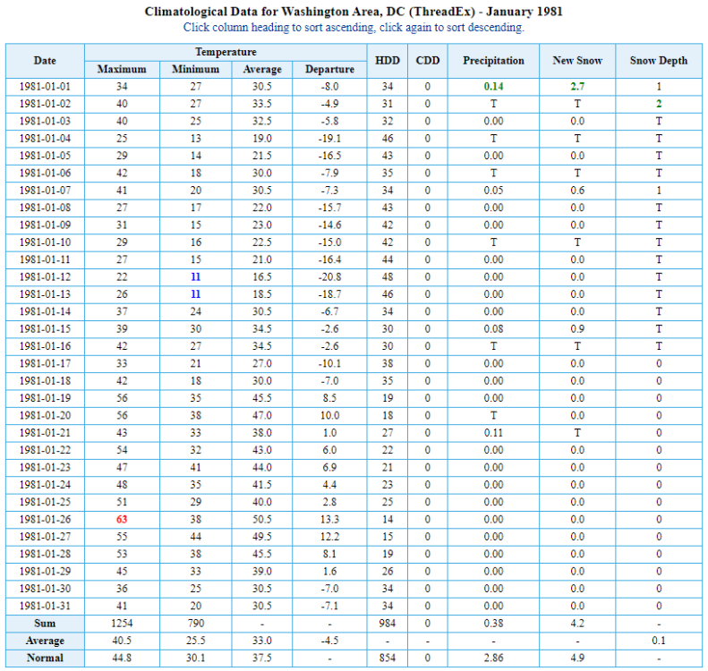
This is Phil's "nightmare fuel" by the way.
That was the only snow we saw all winter, dude. Also my area was shafted by that clipper, ended up in a dryslot between bands w/ ~ 1” at most. Rare winter when DCA ended up with more snow than us.
I wasn’t alive yet, but I pretty sure I would’ve hated that winter as much as I hated 22/23.
-
1
-
-
1 hour ago, TT-SEA said:
Liking the 00Z GFS so far... beautiful weekend then rain on Monday and clearing Tuesday and then back to sunny and mild.
Seen this skit before.
-
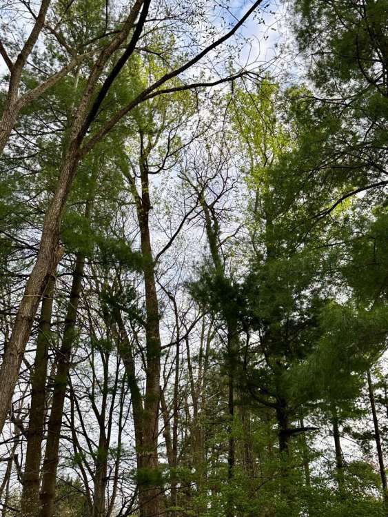
Apparently the trees don’t think cold weather is coming back.
They’re seldom wrong.
-
1
-
-
1 hour ago, MossMan said:
Looks like a stout -PNA is still coming. Perhaps it will even snow!
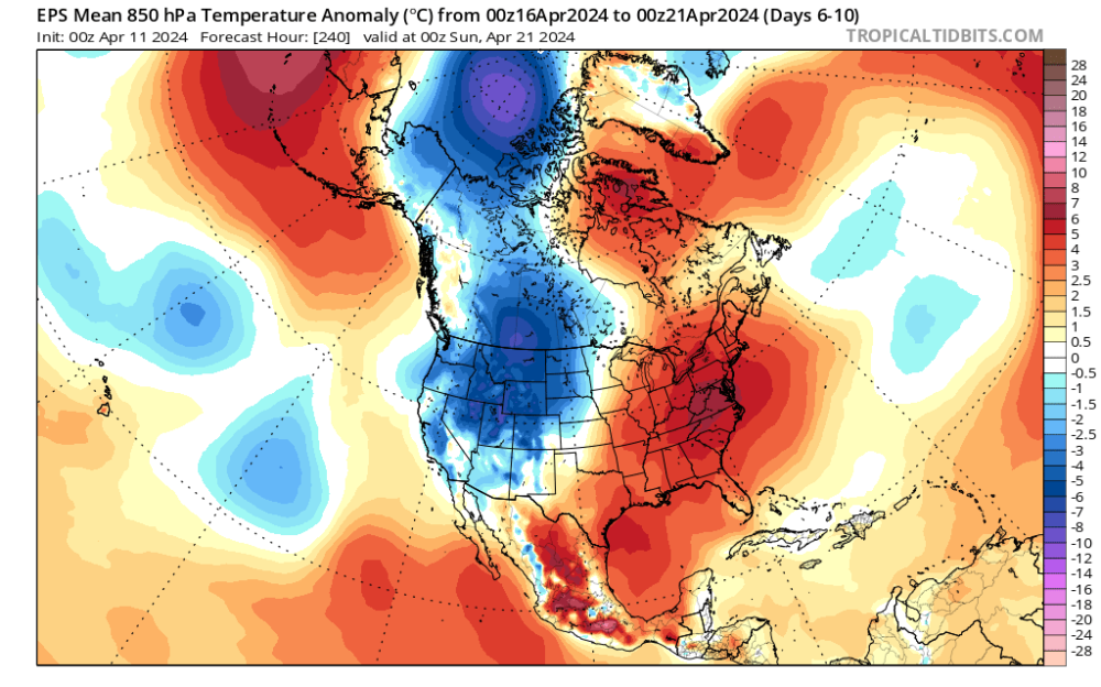
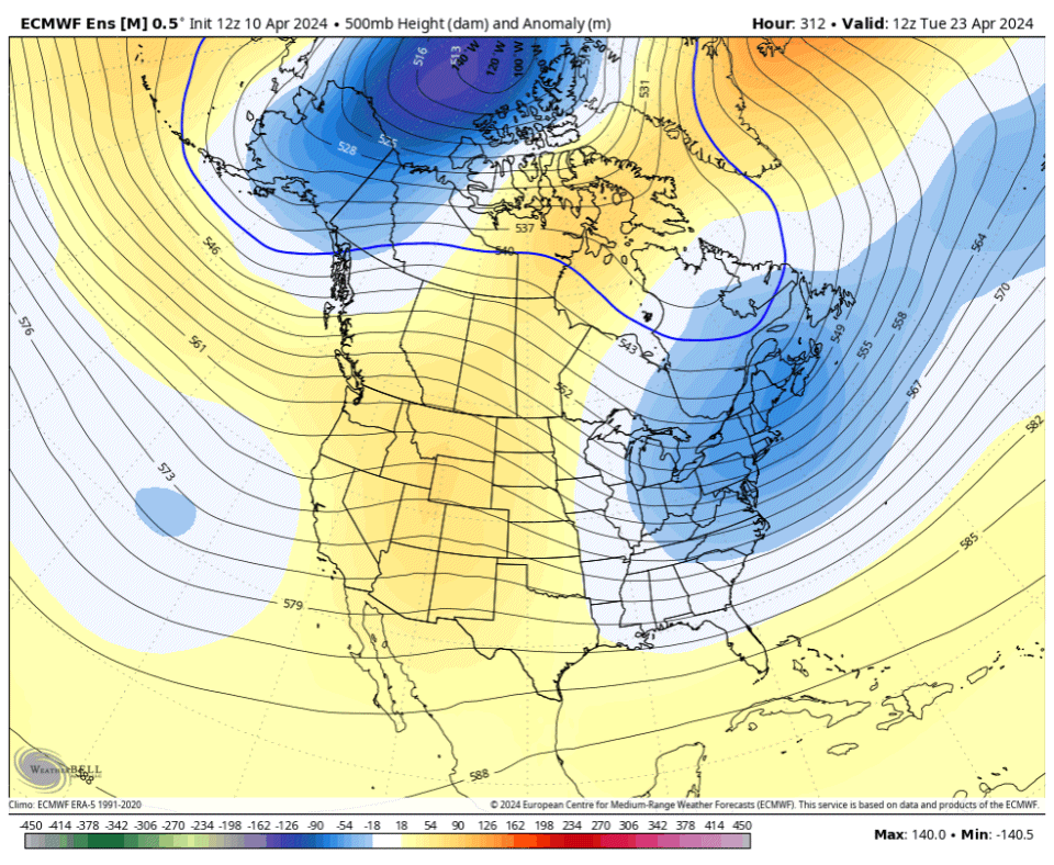
Late month +PNA starting to show up!
-
1
-
 1
1
-
-
1 hour ago, Meatyorologist said:
Guidance has a nice lobe of cold air sitting for days north of AK. Could be something to feed off as more cold air spills south into the GOA from there via the Beaufort Sea.
Was going to say, that’s actually an impressive airmass sitting over the Beaufort/W-Arctic and AK week-2. Climate rapture-ists might have to wait another year for an ice free arctic.
-
1
-


April 2024 Weather in the PNW
in West of the Rockies
Posted
You’re about to be on the heat miser blacklist.