Phil
-
Posts
44502 -
Joined
-
Last visited
-
Days Won
262
Everything posted by Phil
-
Except when it’s not storming and just hot & nasty as fück.
-
That’s the one thing I love about summer. Nothing quite like sitting at the front porch, drink in hand, watching strobing lightning in the distance (and pouring sweat most times, lol).
-
Lol. That is the nastiest pattern possible here in the summer. Thank goodness it’s April.
-
I’ll take your word for it, as I haven’t been following other regions’ mesoscale-synoptic details all that closely. I’m being somewhat imby-centric, as the late week trough out here was originally projected to kick off a more prolonged troughy stretch, but that has reversed entirely. Or at least been delayed substantially. I’m still optimistic the current pattern will take a break later this month into May, but I’m not confident it will last long.
-
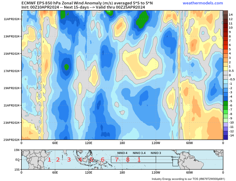
Dr. Roundy’s MJO-only composite does project a more +PNA type pattern late-April to mid-May, but the duration has been cut. This product did perform well last summer, though. So if it’s correct, there should be a ~3 week stretch that leans +PNA and/or +TNH starting during the 3rd week of April. We’ll see. https://www.atmos.albany.edu/facstaff/roundy/waves/rmmcyc/indexmjo.html
-
Not a “total outlier” if you look at the individual solutions, but definitely a minority cluster (for now). But the same was true a week ago, and look what happened. Models keep dangling a +TNH/+PNA reprieve, but yank the rug when it gets to within a week. Combination of bad luck and transitioning long period tropical forcing. I’m going to assume the second half of April will feature some kind of ridge/+TNH type pattern simply based on the evolution of the MJO. But it looks more fleeting than it did originally, as we return to E-Hem forcing by early/mid May.
-
Probably a dust devil, absent the dust. Winds can reach 70+mph in those suckers.
-
Just went through 3 years of this and now it’s back again. Trades everywhere. Enjoy repeating the medieval megadrought.
-
12z CMC wants to continue the Jesse pattern indefinitely. Gets us into the 90s next week FFS. Dumb a** s**t.
-
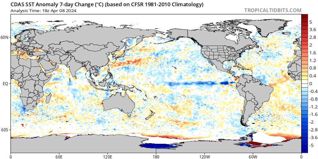
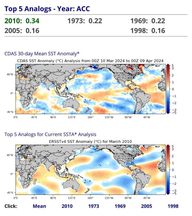
2010 still far and away the best SSTA match.
-
That was one of the lamest winters in history out here as well. Grand total locally was < 2”. Also the worst dry/windy combo in the post-WWII era. Overall it’s probably tied with 2022/23 for #1 atop the nightmare fuel list.
-
So was 2018/19. And 1968/69. Weak niños can do weird stuff.
-
2016/17 should be considered neutral as well. Tropics were devoid of any niña characteristics by January.
-
The GFS is way too far offshore with next weekend’s ULL. I don’t even need to look at other guidance to know it’s wrong. Was wondering when we’d start seeing that springtime bias manifest. Hasn’t been as bad this year (so far).
-
You’d be without power for a month.
-
Maybe 90/91? “All around” is a subjective term. For all intents and purposes, 16/17 was also a neutral winter, as it completely lost any semblance of LF niña forcing in Jan (and was closer to niño-costero by Feb).
-
The love for niñas is understandable but misguided.
-
You know the cold season is on its deathbed when it’s pushing 80°F despite mostly cloudy skies. Might’ve had our last sub-60°F high until Oct/Nov.
-
Yeah 1975/76 was possibly the strongest niña of the 20th century and it was relatively mediocre. Even had +QBO/-PMM and healthy W1 IPWP signal. But it’s possible the niña got so strong it essentially shut down the intraseasonal/MJO components that are crucial to amplifying wave activity. Which would explain why the PV was so outrageously strong that entire winter.
-
I’ve been digging thru the ENSO progression of every WW-II year looking for failure modes of developing niñas, and I think the best we can hope for now is a weak niña featuring more of a 2 wave low pass signature (IPWP and W-IO/ATL). There’s still a chance this thing fails to gain amplitude after Oct/Nov and weakens thru the winter. But I’ve lost hope at avoiding the niña altogether. And given the QBO transitioning over summer and in-situ -PMM, a rapid crash like 2010 is probably the more likely outcome. But..technically anything is possible. Mother Nature built the sandbox, we just play in it. Who knows what other modes of variability exist within the system but haven’t been observed yet due to our limited data sample (even 200yrs would probably only cover ~ 40% of change-EOFs possible in today’s climate). That’s the main limitation of analog methods of seasonal forecasting. Can’t solve a puzzle if you’re missing half of the pieces.
-
Slow down plz.
-
That has to be in jest.
-
Yeah no streetlights came on, just some neighbors’ hyper-sensitive front door lights. Same, was in GA for 2017 eclipse which was ~ 90% totality there, so this was basically the same.
-
Got dark enough here for neighbors’ lights to come on briefly. The dim sunlight was kinda spooky. Temp dropped by ~5°F Much lighter now.
-
Models have been over-amplifying the week-2 pattern for awhile now. It’ll probably end up more progressive than even the EPS mean as we have a long period +dAAMt coming up.