


Phil
-
Posts
44503 -
Joined
-
Last visited
-
Days Won
262
Posts posted by Phil
-
-
4 minutes ago, Frontal Snowsquall said:
A derecho?
It was an MCS. Would have to meet a lot more criteria to qualify as a derecho.
But it’s the type of pattern that often produces progressive derechos. Just a bit early in the season, harder to maximize potential.
-
 1
1
-
-
Went for another run in the r**n today.
Dangerous, I know. But by the skin of my teeth, I survived.

-
1
-
 1
1
-
 1
1
-
-
10 minutes ago, Cascadia_Wx said:
Having a ridge sit over us 6-7 months a year during the warm season didn’t used to be the norm, but I guess it is now.
Troughing has been the default there for the last 6 weeks but you’re acting emo over a ridge 10 days away?
The same WPAC/dateline MJO that will force the ridge will also force the subsequent troughing/-PNA when it returns to the IO/E-Hem a few weeks later.
It can’t be troughy 24/7/365.
")
-
2
-
1
-
-
Just now, Deweydog said:
MJOWUFBACDFBAWU.
Beat that, Mr. Smarty McAcronymson.
ABCDEFU
-
 1
1
-
 1
1
-
-
38 minutes ago, Phishy Wx said:
RIDGE season is upon us
It’s called the MJO.
")
-
1
-
-
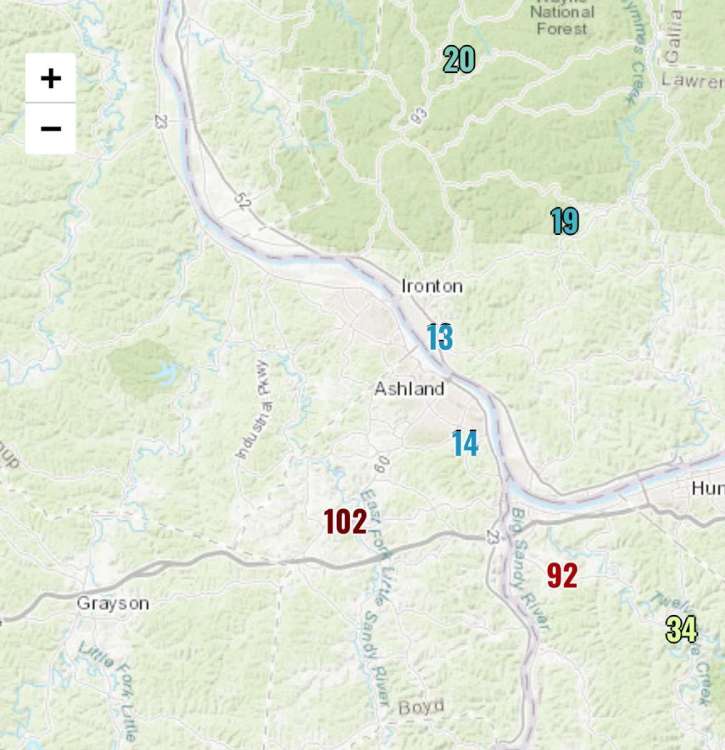
11 hours ago, Phil said:
Idk where in Ashland TimmySupercell lives but a nasty wind core passed very close to him this morning.
-
2
-
 1
1
-
1
-
-
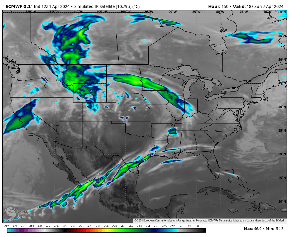
Looks like the wind core went through the south side of Ashland. Gusts to 92mph and 102mph at two different stations.

-
1
-
1
-
-
2 hours ago, Hawkeye said:
Timmy Supercell had a nasty line move through his town a couple hours ago. An automated station not too far away recorded a 90 mph wind gust.
Hope he’s alright, haven’t seen him online since it passed thru.
-
6 hours ago, Timmy Supercell said:
Another cooldown on the way after the storms, even some nighttime snow.
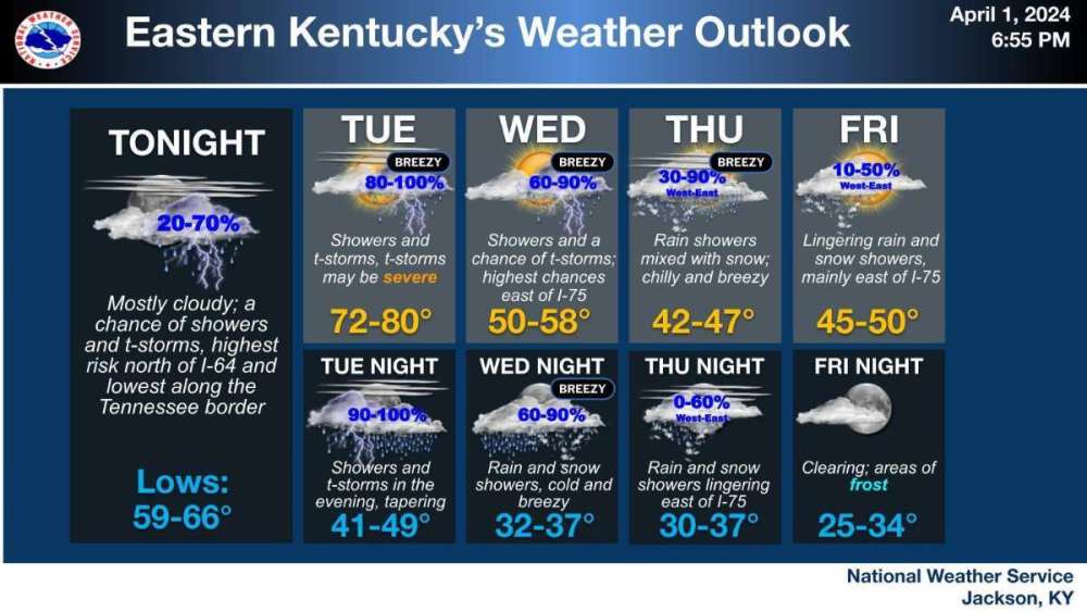

Welcome to spring in the east.
Moderate risk for you today!

-
 1
1
-
-
-
2 hours ago, TT-SEA said:
GFS doesn't show precip in Texas now... but still not favorable in terms of clouds.
.thumb.png.0322961d06099ab1a37d20420b81c55e.png)
The GFS is useless for cloud cover.
-
2 hours ago, GHweatherChris said:
Again, what? Did you smoke some homegrown Stampede Pass green tonight? There is nothing that changes the view of this forum on mobile or PC...
That’s what I said.
-
I’m dumber than a sack of rocks.
-
 2
2
-
-
3 minutes ago, GHweatherChris said:
literally nothing other than the gay a** colors for seasons has changed in months on here........ years actually.....
Hahahahahaha. Holy s*** I see what I did now, it’s that button on the top right of main page. Somehow was oblivious to it until now.

-
1 hour ago, GHweatherChris said:
huhhhhh what..............?
Or I just didn’t notice it before. That level of ADHD isn’t beyond me.
-
Loving the new option to view the entire forum as opposed to switching between regional subforums. So much easier.
-
 1
1
-
2
-
-
2 hours ago, Timmy Supercell said:
A Moderate Risk was just placed in central/eastern Oklahoma!
Is this mid-day light rain/cloud gonna clear in these areas? Both here and there looks like we're socked in, and this has been occurring since I moved here. Stuff is thinning but I haven't seen the sun shining all day.
This type of setup is less reliant on insolation/sfc heating than the kinematic/forced components, relatively speaking. If you’re near/south of the warm front, you’re in the game. NW flow aloft with low level WAA is notorious for nocturnal severe, both super-cellular and MCS-type variety.
Generally speaking, SBCAPE/surface heating becomes more important later in May into the summer months. But of course it’s not always the case..each situation is unique to some degree.
-
 1
1
-
-
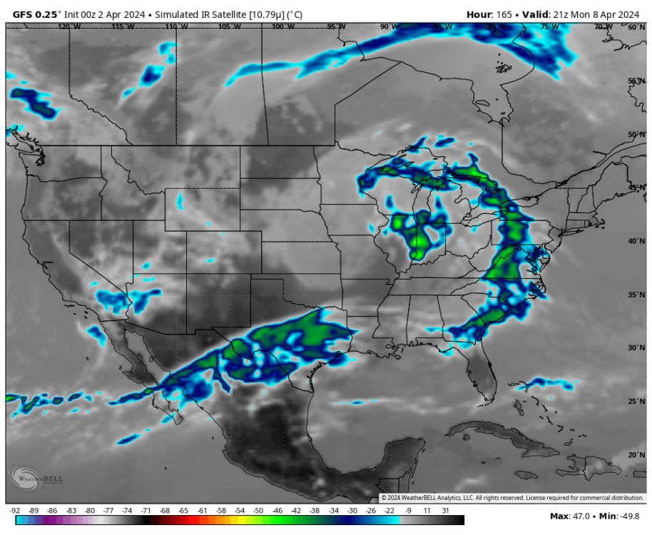
30 minutes ago, Sunriver Snow Zone said:
Anyone have the Euro cloud cover map for 18z April 8th in the Texas area? Pivotal only shows precip, need piv+ to see the cloud map.
It seemed like a pretty good run but idk

-
 1
1
-
-
2 hours ago, iFred said:
CanSIPs has been pretty aggressive about DJF for the past few months. Maybe more of a feedback thing than anything else, but always fun to dream.
Seasonal/climate models will typically default to the canonical ENSO response, particularly during boreal winter. The components of subseasonal variability are always underestimated, and in fact are near impossible to project dynamically from such ranges.
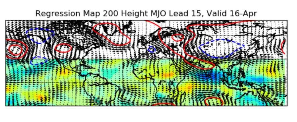
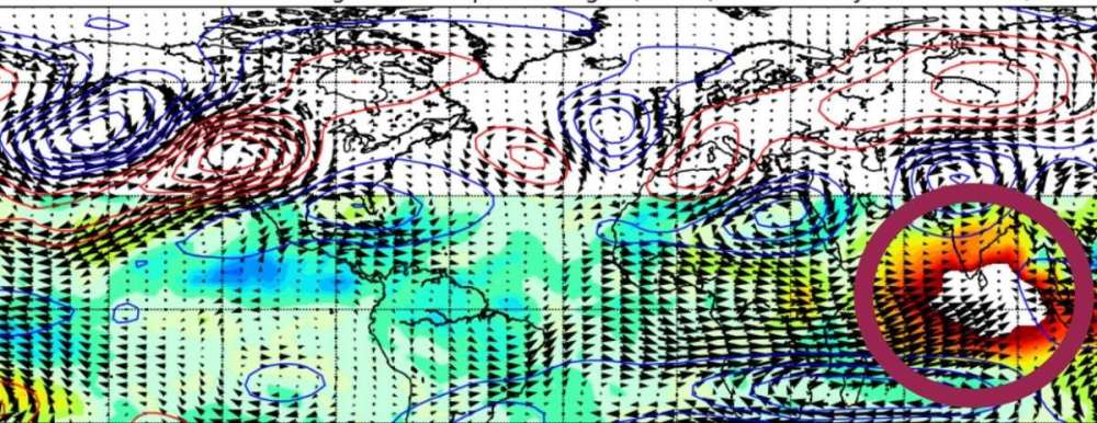
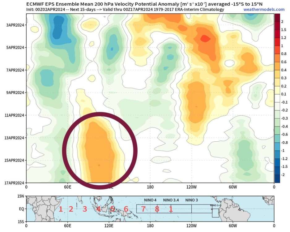
Seasonal forecasting is actually the area where AI/statistical models have the greatest potential to improve predictability. Factor in enough inter-related components (QBO, subseasonal modes of tropical forcing such as MJO, ERWs, & OKWs, Atlantic/Pacific meridional modes, annular modes, ENSO, etc) and their statistical+dynamical relationship(s) with one another, and you will see a substantial increase in predictability in both seasonal and subseasonal frequencies at very long ranges (possibly 6+ months).
-
2
-
-
8 hours ago, Sunriver Snow Zone said:
Fun fact, in modern US history, more people have been killed by sheep than by wolves.
D**n. Andrew had better watch his back.

-
1
-
-
Omg STFU. Demonic insomniacs.
-
holy ducting thunder batman. I felt that in my chest.
-
3
-
-
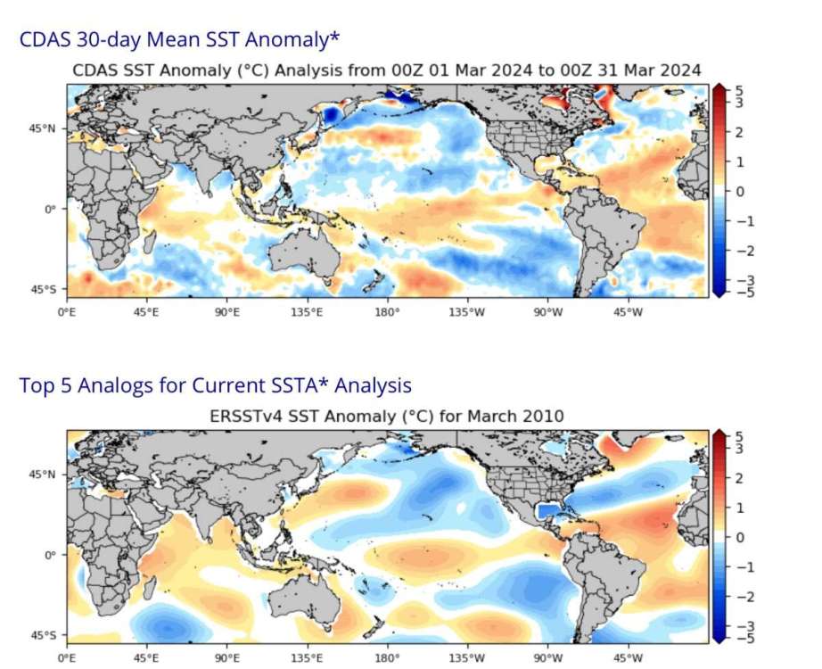
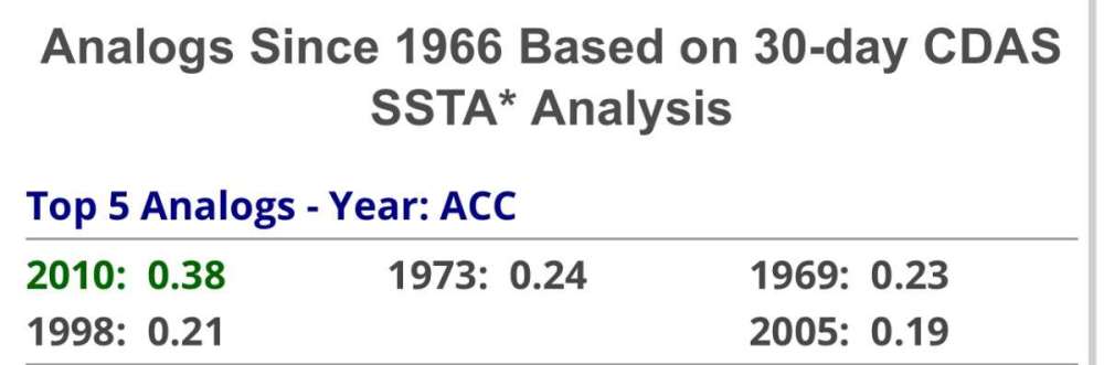
42 minutes ago, Cascadia_Wx said:
That was a lovely late spring and summer out here. Had a warmer than average Feb/March as well, like this year.
The global SSTA match with 2010 borders on spooky. Far and away the closest fit, with 1973 the runner-up.
Also the descending NE-Canada block fits the 2010 progression. As does the descending +QBO with -PMM/+AMM.
Below are SSTAs in 2024 (top) and 2010 (bottom) with global anomaly adjusted to zero. Crazy homogeneity.
-
1
-
-
Last time we had back to back nights with thunderstorms in March was 2010. Noticing a lot of similarities to that year, though timing shifted a few weeks.
-
5
-


.png.3c36f8e55deedf6190d40530840afcaa.png)


April 2024 Weather in the PNW
in West of the Rockies
Posted
No wonder Timmy’s been knocked off the grid.
Also lmao