Perturbed Member
-
Posts
5085 -
Joined
-
Last visited
-
Days Won
2
Everything posted by Perturbed Member
-

January 2024 Weather in the PNW (Part II)
Perturbed Member replied to Meatyorologist's topic in West of the Rockies
IBM/Weather.com is all we have got left down here in PDX. Doesn't look like they got the memo from the GFS yet.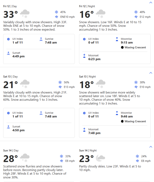
-
January 2024 Weather in the PNW (Part II)
Perturbed Member replied to Meatyorologist's topic in West of the Rockies
UKMET is pretty depressing. Rapid warming aloft and a quick snow to sleet/ZR transition. 850s already above freezing by Saturday AM for PDX. No matter how you slice it, this solution is a nod in the direction of the GFS's crap solution. -
January 2024 Weather in the PNW (Part II)
Perturbed Member replied to Meatyorologist's topic in West of the Rockies
Yeah, for all the GFS mocking that has been done, the bastard has held its own against all the other models and has been the first to pick up on certain features that later showed up on the others. The GraphCast and its whitepaper that claims total superiority over all other numerical prediction models is going to look a bit silly if this completely fizzles. -
January 2024 Weather in the PNW (Part II)
Perturbed Member replied to Meatyorologist's topic in West of the Rockies
Only the euro can stop Rod Hill's forecast from verifying now. After the 12z suite today I commented on how the models had generally moved away from quickly marching -20c or colder 850mb temps into PDX end of week and instead were only dropping to -7c to -12c. That was really the first clear sign that models were not being nearly as aggressive in pushing the cold air SW as much. These crap 00z runs seem to just continue that trend, with the cold air barely making it south of the border now. I don't have much faith in the ICON so the Euro stands alone now and hopefully stands its ground. We are under 100 hours out from when the cold air should be diving south into the region. Time is running out to undo these trends. -
January 2024 Weather in the PNW (Part II)
Perturbed Member replied to Meatyorologist's topic in West of the Rockies
My thoughts too. I got a bit cocky and assumed the GFS would cave to the other models tonight and we would have consensus. Hopefully we can make something happen Tuesday night since this entire event could end up being just a 30-40 mile stretch of wet isothermal slop somewhere on I-5 and nothing after. -
January 2024 Weather in the PNW (Part II)
Perturbed Member replied to Meatyorologist's topic in West of the Rockies
Pretty huge step towards the crap GFS on the GEM. The arctic front doesn't make much southward progress, that low offshore is nowhere near as suppressed and now heads way north. Compare 00z vs 12z GEM This looks much closer to the gross 00z GFS By comparison, the 12z Euro had that low near the OR/CA border. If the Euro doesn't hold its ground tonight, it could get pretty ugly. -
January 2024 Weather in the PNW (Part II)
Perturbed Member replied to Meatyorologist's topic in West of the Rockies
I think we will probably end up in a pretty nice spot. Very cold with a frigid east wind with systems trying to push in from the south. Being on that boundary between the cold and the moisture to the SW with the gorge doing its thing, pretty nice place to be and about as good as we can do here to get a shot at some real widespread snow. -
January 2024 Weather in the PNW (Part II)
Perturbed Member replied to Meatyorologist's topic in West of the Rockies
GEM -
January 2024 Weather in the PNW (Part II)
Perturbed Member replied to Meatyorologist's topic in West of the Rockies
The previous run had the low way into California. It has moved a good bit further north relative to that. -
January 2024 Weather in the PNW (Part II)
Perturbed Member replied to Meatyorologist's topic in West of the Rockies
GFS is a bit further north with the Tuesday night low -
January 2024 Weather in the PNW (Part II)
Perturbed Member replied to Meatyorologist's topic in West of the Rockies
Yeah, I understand that they want to show that there is significant uncertainty and want to express the forecast as a probability distribution, but their job is ultimately to interpret the data and distill it into clear and easy to understand recommendations and predictions. The way they are writing these AFDs and forecasts, it essentially boils down to "anything and everything is technically possible". It just isn't that useful to write that same message over and over. -
January 2024 Weather in the PNW (Part II)
Perturbed Member replied to Meatyorologist's topic in West of the Rockies
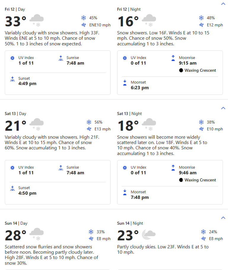
PDX NWS calls for a 1400 ft snow level Friday AM and 1700 ft by Friday night, rising to 2100 ft by Saturday. I have no problem with this, the last time PDX NWS completely ignored the models and downplayed everything we ended up with 6-12 inches of snow pretty widespread here in Feb 2023. -
January 2024 Weather in the PNW (Part II)
Perturbed Member replied to Meatyorologist's topic in West of the Rockies
ICON is a bit further south with that low Tuesday. Bullseye near SLE. At least snow in the air or mix for a lot of us around here is probably a good bet with this one.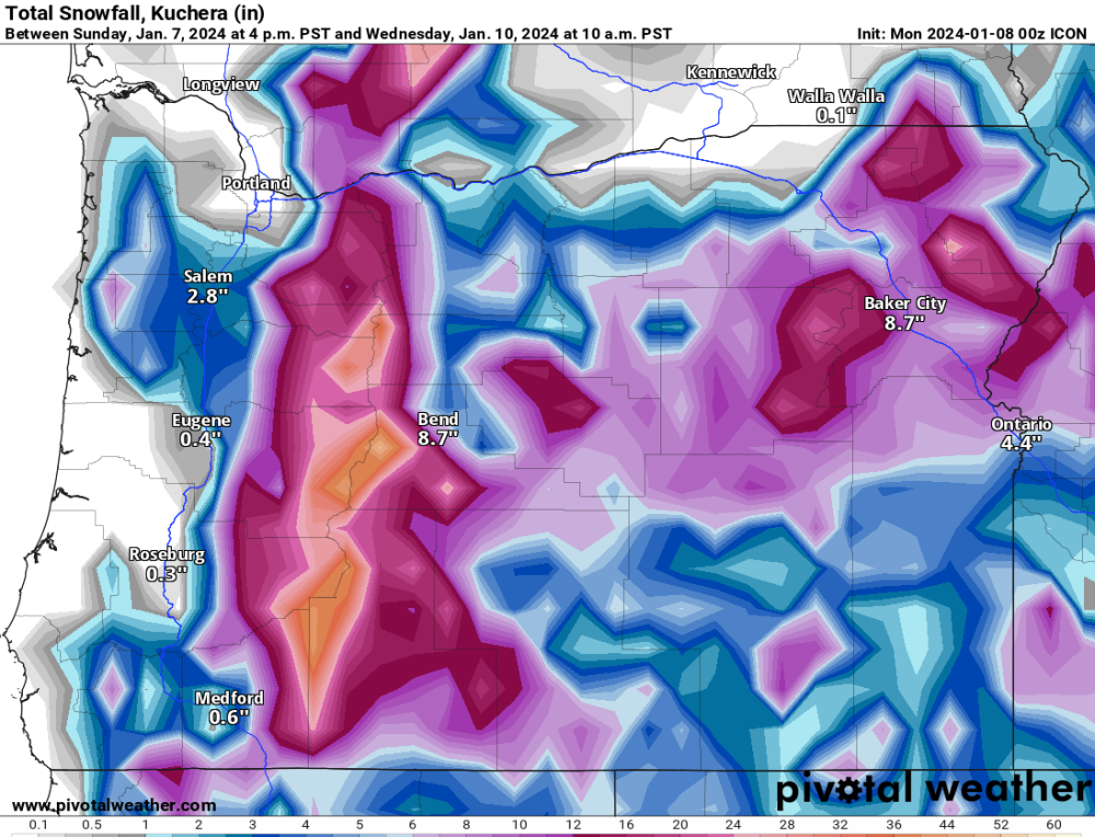
-
January 2024 Weather in the PNW (Part II)
Perturbed Member replied to Meatyorologist's topic in West of the Rockies
Interesting to look at the position of the Friday-Saturday system across different models. The GFS is way north since it doesn't send the cold air as far south to begin with. The ICON and Euro are much more suppressed and send it way into California. The GEM and UKMET are in between and hit Oregon a bit more directly but are still mostly focused on southern OR. -
January 2024 Weather in the PNW (Part II)
Perturbed Member replied to Meatyorologist's topic in West of the Rockies
I think it is possible but there isn't much margin for error there. I bet there will be accumulating snow to the valley floor somewhere that night, just not sure where. The euro bring that low in pretty much just right for Portland. I have my doubts it will playout exactly like this in reality.
-
January 2024 Weather in the PNW (Part II)
Perturbed Member replied to Meatyorologist's topic in West of the Rockies
Probably a best case scenario shown here for the Tuesday night system. Offshore flow with the low swinging by south with good precip rates to maybe have a shot at going isothermal. Obviously pretty dependent on how that low ends up tracking too. Too bad we don't have a cold Columbia basin already going into this. A budget 1/10/17 repeat would be pretty fun. -
January 2024 Weather in the PNW (Part II)
Perturbed Member replied to Meatyorologist's topic in West of the Rockies
Previously some models had been showing the arctic front flying south with 850s quickly dropping to near or below -20c in PDX. Not surprisingly this has now pretty much disappeared as it usually does from models as we get closer and things sober up. With the exception of the ICON, the rest of the models show -7c to -12c around PDX with the initial cold shot which is much more in line with what we usually get with these kinds of events. The GFS of course is still much warmer than even these numbers. Outside the GFS, model agreement of -15c or colder 850mb temps into SEA by Friday AM looks good. -
January 2024 Weather in the PNW (Part II)
Perturbed Member replied to Meatyorologist's topic in West of the Rockies
The PDX one is impressive. The first 1-2 inches of that average is phantom snow falling tonight and tomorrow though. These Euro snow maps are just too generous in marginal temps. -
January 2024 Weather in the PNW (Part II)
Perturbed Member replied to Meatyorologist's topic in West of the Rockies
All this model riding has made me lose track of the weather right now. 38F and absolute downpour here. I see some snow starting to fall in the coast range and some sticking snow down to 1000ft.
-
January 2024 Weather in the PNW (Part II)
Perturbed Member replied to Meatyorologist's topic in West of the Rockies
-10c 850mb temps to SEA is less than 120 hours away. The Euro doesn't miss often within this range especially when it has been fairly consistent run after run like this. I still have no idea if we're really going to get these unhinged temps on the 00z GEM and Euro but I'm pretty sure the cold is happening, top tier or not. -
January 2024 Weather in the PNW (Part II)
Perturbed Member replied to Meatyorologist's topic in West of the Rockies
Last 3 UKMET runs A small improvement from the crap 12z run maybe but not where it needs to be unfortunately. -
January 2024 Weather in the PNW (Part II)
Perturbed Member replied to Meatyorologist's topic in West of the Rockies
So historic cold still on the table according to ICON and GEM. Feeling good that the 00z Euro will most likely confirm the GEM or a more realistic version of it and the GFS will either come to its senses 06z or sometime tomorrow. Willing to bet the UKMET will swing right back to the cold solution as well. Hopefully within striking distance of locking this event in with model consensus. It isn't scientific but I'd like to add that the ICON doesn't like to show snow down here half the time even when it actually does snow. Might be the stingiest model with snowfall. When the 00z ICON shows widespread snow here, something is usually up. -
January 2024 Weather in the PNW (Part I)
Perturbed Member replied to Sunriver Snow Zone's topic in West of the Rockies
I think the most positive thing I'm seeing about this is that there seems to be a decent amount of margin for error in terms of what can happen leading up to this and still get good results. That low blowing up Monday evening - Tuesday is looking pretty much like a lock now but it seems that can be allowed to happen and it is still possible or even likely that the cold air eventually makes it down. The crap GFS run is much less worrying with the Euro still holding relatively steady compared to other models. The GEM solution is great but it has looked wildly different every run for a while now. It is a pretty complex evolution given how hard the UKMET, GEM and GFS are flailing around run to run. -
January 2024 Weather in the PNW (Part I)
Perturbed Member replied to Sunriver Snow Zone's topic in West of the Rockies
Agree, I suspected it was a fluke on the 00z GFS but we saw a similar hint on the 00z Euro and the GFS doubled down on it for the 06z. That low rapidly deepening like that is also somewhat supported by the mesoscale models. It is still possible that feature doesn't pan out but we can't pretend it is just made up nonsense anymore. Unfortunately, that low getting that strong simply throws a wrench into the rest of the mechanism needed to deliver the goods. -
January 2024 Weather in the PNW (Part I)
Perturbed Member replied to Sunriver Snow Zone's topic in West of the Rockies
Yeah that strong low isn't some random thing that the GFS just made up, seems to be a legit possibility and it makes it significantly less likely that the really deep cold air can make significant progress to the SW. It is still possible the cold air makes it far enough south into northern areas such that Washington sees snow or we could get a backdoor blast into the Columbia basin, east winds into PDX and an overrunning event. There is really no way around it though, unless we see a significant reversal of these trends this event is going to probably get more marginal and nowhere near as cold as the historic cold maps we were seeing the past few days. Areas south and especially south of PDX are disproportionally screwed by these changes. Lets hope for better runs tomorrow.