


Abbotsford_wx
-
Posts
363 -
Joined
-
Last visited
Everything posted by Abbotsford_wx
-
Easiest way is to just use entire year... January 2000 to December 2009.
-
+1.4F at Abbotsford. I find the BLI number surprising.
-
Right, I must have been confusing that with Feb 2014. Two good events that winter down there that were pretty forgettable up here.
-
I couldn't even remember December 2013... had to look it up... lol. Almost a non-event up here.
-
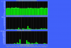
No temperature trend at all over the past 30 days. The white line is 10C (lots of days averaging near that mark this month). With today's rain I'm at 9.93" of rain so far this month.
-
I've only gotten .38" of rain in the last six days. Just a trace so far today. The first half of the month was very wet, but it won't come close to 2003. We're currently at just over 9", and we'd need over 14" to beat 2003.
-
The Chilliwack snowfall data is very suspect. They recorded 102 cm over four days, but only measured 36 cm on the ground at the end of it. The temperature never rose above freezing during that period. Compaction and sublimation can only account for so much loss. Either one or both of those measurements is way off. The problem inherent with measuring snow in an outflow area (particularly one that is very exposed), is that the winds are often so strong that any measurement is little more than an educated guess. You're supposed to measure in several places (including drifts) then average the measurement. It's pretty obvious that protocol was not followed in this case.
-
I dunno, I've seen a few wind storms bust up here. Bellingham always tend to get hit though, even when the winds bust everywhere else.
-
Yeah, it's pretty bizarre. The low followed a nearly ideal track for this area. Every single model was showing extreme wind up here. Not much in the way of heavy rain, either. You'd never guess it was the remnants of a typhoon. Yesterday's storm had far more convection.
-
SEA is back up to 34 kt gusts with the squall line.
-
Apparently the storm is still deepening... 968 mb at Tatoosh Island... definitely an incredibly compact low.
-
yeah, seems odd given that it also trended weaker than expected. Usually it's one or the other.
-
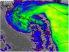
Surprised it's so far offshore. Looks closer to the coast on the satellite images.
-
Okay.
-
Maybe your area is different, but it looks like 7-9 pm for peak winds in Seattle.
-
There was never supposed to be much wind until around 8 pm, so commenting on the lack of wind right now seems kinda silly. And we knew this was borderline for Seattle-south anyway.
-
Haven't seen it but I'd say it's an outlier based on the satellite images.
-
12z... 966 mb
-
Just got 0.6" in one hour.
-
I'm hoping for at least 62 mph (100 km/h) at Abbotsford. It's been 7 years since we last hit 100 km/h. We typically see winds of that magnitude every 3 years or so.
-
That is totally understandable. I'm pretty fortunate because I live in an area that is usually very quick at restoring power. I can't think of a time in my life where the power was out for more than 18 hours or so (that includes when I lived in more rural areas than I do now). But I could definitely see it becoming a drag after a day or so.
-
Much cooler here. I'm at 40, last night I was 49 at this time.
-
Mets up here are referencing October 2003... lots of rain that month (but I don't recall a lot of wind). I think 2009 was more serious down there than it was up here.
-
On a clear night I start looking for frost at about 39F. You'll usually find some if you look in the right places. Roof shingles cool very effectively by radiation, so they tend to be one of the first places to show frost. Yeah, there's a difference between frozen dew and frost, but to the layman they're the same thing. I've never heard a forecaster predict frozen dew, despite the fact it's probably just as common as "real" frost in the Pac NW because dew points usually start out above freezing and may not reach freezing until early morning. You can sure tell the difference when you're scraping your car windows - frozen dew is far more difficult to remove.
-
A high of 50.7 and 2.1" of rain here today.


