


dubuque473
-
Posts
408 -
Joined
-
Last visited
Everything posted by dubuque473
-
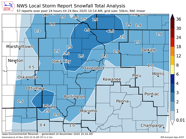
Not bad, 7.8” here! Still hoping to get 3” however.
-
Swails: Right now I think the GFS is an outlier and I'm leaning toward the EURO and GEM snowfall solutions which are significantly higher. All 3 are posted below. I do want to stress there is still room for change and confidence is only low to moderate in any outcome.
-
DVN has me at 3-6” now... Friday Night A chance of rain before 8pm, then a chance of rain and snow between 8pm and 11pm, then a chance of snow after 11pm. Cloudy, with a low around 32. Chance of precipitation is 50%. New snow accumulation of 1 to 2 inches possible. Saturday Snow likely. Mostly cloudy, with a high near 35. Chance of precipitation is 60%. New snow accumulation of 2 to 4 inches possible.
-
Hoping for 3”. Will see what happens once it comes ashore tomorrow.
-
Well I have the 69% going for me at least...
-
UKIE would be 13” for me lol
-
Off with a back injury so kind of expect a lot.
-
DVN giving me hope for at least something.. Northern stream energy will be onshore Thursday night and its strength and evolution with lead southern stream trof will help determine how strong our Friday-Saturday system will be. Both the 00z NAM/00z ECMWF show a negative tilt wave developing which results in a stronger and slower dynamic system and in contrast the 00z GFS/GEM show more a neutral tilt to this incoming system, which would be somewhat weaker and faster moving. Surface low track has come into slightly better agreement with 00z runs and their ensembles, with a consensus track from SGF at 00z Sat, to STL, to northern IN by 18z Sat. This normally would favor the local area receiving heavy snowfall. However, the complicating factor with this system as mentioned in previous discussion is that we will have no cold arctic air in place. We will have to depend on strong dynamics and high snowfall rates to get snow to accumulate on warm ground/pavement. This is still a possibility, but confidence still remains low. QPF/Snowfall... Model PWs will be rising above 0.75" which is 2-3 standard deviations from the climatological mean per NAEFS output. Strong lift ahead of the wave will result in rainfall totals over a half inch by Saturday, especially in our southeast half of CWA. Lighter amounts are expected further north and west. NBM weather type progs have been trending further south with the rain/snow line late Friday night, with most areas north of a Fairfield to Quad Cities line seeing a changeover to all snow early Saturday. Latest 00z NAM and WPC internal snowfall guidance would suggest a def zone snowfall region and potential accumulating snow to set up somewhere over south central IA through the Cedar Rapids/Iowa City metro, to Freeport,IL on Saturday, with little to no accumulating snow south and east of this line. Any deviation or change in low track in later forecasts will shift this snowfall area. Wide range of possible snow totals still exist and will be further addressed in later forecasts.
-
I could handle that....
-

-
And probably 50 degrees here lol
-
30 years ago this week we had a 15” snowfall with 56mph gusts. I think things will change mid month for the better.
-
Appears I ended up with around 4”
-
Couple inches up here, 2” for sure. Absolutely beautiful out!
-
DVN saying around an inch along I-80, 2-3” North of Highway 30...looks like I am in the right spot. We shall see..
-
DVN has me down for 1-3” now Monday night..
-

10/25-10/27 Winter Storm & Cold Snap
dubuque473 replied to snowstorm83's topic in East of the Rockies
We set our record last October in snowfall so I can take some or leave it. Still... a half an inch would be nice just to watch. -
2/24-2/26 Snow (Ring the doorbell so the big dog wakes up!!!)
dubuque473 replied to Madtown's topic in East of the Rockies
See you in March! -
2/24-2/26 Snow (Ring the doorbell so the big dog wakes up!!!)
dubuque473 replied to Madtown's topic in East of the Rockies
I see NWS just out a graphic up on FB that says 5” for me...have a hard time believing that at this point. -
2/24-2/26 Snow (Ring the doorbell so the big dog wakes up!!!)
dubuque473 replied to Madtown's topic in East of the Rockies
I am down to 3-6 with the WSW dropped... -
2/24-2/26 Snow (Ring the doorbell so the big dog wakes up!!!)
dubuque473 replied to Madtown's topic in East of the Rockies
-
2/24-2/26 Snow (Ring the doorbell so the big dog wakes up!!!)
dubuque473 replied to Madtown's topic in East of the Rockies
Until otherwise I am going with DVN’s 8-13” for me -
2/24-2/26 Snow (Ring the doorbell so the big dog wakes up!!!)
dubuque473 replied to Madtown's topic in East of the Rockies
First time in 3 years I will have to refill my 2-Stage. -
2/24-2/26 Snow (Ring the doorbell so the big dog wakes up!!!)
dubuque473 replied to Madtown's topic in East of the Rockies
I would take 17.3 -
2/17-2/19 Weather (Somethings brewing, but might just be coffee)
dubuque473 replied to Madtown's topic in East of the Rockies
Pound town here for quite awhile. Not building up but huge flakes at a moderate rate for the past few hours. Most beautiful daytime snow of the season so far. Melting at a good rate though...


