.jpeg.3a024d4b702f7a1d37ccc50cc74d07e5.jpeg)
MR.SNOWMIZER
-
Posts
14194 -
Joined
-
Last visited
-
Days Won
92
Everything posted by MR.SNOWMIZER
-
.thumb.jpeg.e3014abf99ef08a9f9ac2c0cd31b485b.jpeg)
February Weather in the Pacific Northwest
MR.SNOWMIZER replied to Deweydog's topic in West of the Rockies
I wonder who would win in arm wrestling, rod hill or mark nelson? -
February Weather in the Pacific Northwest
MR.SNOWMIZER replied to Deweydog's topic in West of the Rockies
Jaya mentioned alot of this cold is coming from upper levels before the front. -
February Weather in the Pacific Northwest
MR.SNOWMIZER replied to Deweydog's topic in West of the Rockies
I wana ride that chrome 3 wheeler!! -
February Weather in the Pacific Northwest
MR.SNOWMIZER replied to Deweydog's topic in West of the Rockies
Typhoon watch for hawaii. The next 3 weeks. -
February Weather in the Pacific Northwest
MR.SNOWMIZER replied to Deweydog's topic in West of the Rockies
Every run from this point forward will change. Small changes to any low pressure to the south of the sound will make a large difference. Would help if there was stronger pressure in bc. -
February Weather in the Pacific Northwest
MR.SNOWMIZER replied to Deweydog's topic in West of the Rockies
Very nice afd by the NWS. Explains everything great. -
February Weather in the Pacific Northwest
MR.SNOWMIZER replied to Deweydog's topic in West of the Rockies
Me3 -
February Weather in the Pacific Northwest
MR.SNOWMIZER replied to Deweydog's topic in West of the Rockies
2 inches of snow before going into a cold air mass would be very nice. -
February Weather in the Pacific Northwest
MR.SNOWMIZER replied to Deweydog's topic in West of the Rockies
Hi.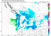
-
February Weather in the Pacific Northwest
MR.SNOWMIZER replied to Deweydog's topic in West of the Rockies
I would think more energy with this situation is a good thing. -
February Weather in the Pacific Northwest
MR.SNOWMIZER replied to Deweydog's topic in West of the Rockies
12z nam even stronger with the low sat. 992 now. -
February Weather in the Pacific Northwest
MR.SNOWMIZER replied to Deweydog's topic in West of the Rockies
The minus ten in eastern wa is no joke. It will be much colder at Bremerton and Shelton I would think. Bremerton was 22 the other night under a much warmer air mass. -
February Weather in the Pacific Northwest
MR.SNOWMIZER replied to Deweydog's topic in West of the Rockies
12 at omak wow!! -
February Weather in the Pacific Northwest
MR.SNOWMIZER replied to Deweydog's topic in West of the Rockies
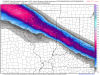
Still shows snow for most everyone and as jaya said ratios could be better than 10to1. A lot can happen with this type of set up as far as where the best convergence is with the front. -
February Weather in the Pacific Northwest
MR.SNOWMIZER replied to Deweydog's topic in West of the Rockies
This has to be decent for some snow.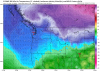
-
February Weather in the Pacific Northwest
MR.SNOWMIZER replied to Deweydog's topic in West of the Rockies
After years of watching the WRF snow maps imo it does pretty fair with warm front over running for the hood canal area. Other places it sure is hit and miss. I was looking at the surface maps frame by frame and was very surprised of the bleak snow maps. Awesome to have your contribution on the forum btw. -
February Weather in the Pacific Northwest
MR.SNOWMIZER replied to Deweydog's topic in West of the Rockies
Most likely your coldest reading with the coming air mass. -
February Weather in the Pacific Northwest
MR.SNOWMIZER replied to Deweydog's topic in West of the Rockies
You would think by what the gfs is showing that the wrf would look much better than it does. Maybe this a good thing. Would like to hear jaya's take on that. -
February Weather in the Pacific Northwest
MR.SNOWMIZER replied to Deweydog's topic in West of the Rockies
Andrew special there!! -
February Weather in the Pacific Northwest
MR.SNOWMIZER replied to Deweydog's topic in West of the Rockies
Just keep coming in the clown range. This really could be a historic cold stretch. The blocking is just crazy. -
February Weather in the Pacific Northwest
MR.SNOWMIZER replied to Deweydog's topic in West of the Rockies
Block remains in great spot entire run so far and looks like it will get really good as we approach long range. -
February Weather in the Pacific Northwest
MR.SNOWMIZER replied to Deweydog's topic in West of the Rockies
GFS does show some getting closer on this run. -
February Weather in the Pacific Northwest
MR.SNOWMIZER replied to Deweydog's topic in West of the Rockies
Cold run so far. -
February Weather in the Pacific Northwest
MR.SNOWMIZER replied to Deweydog's topic in West of the Rockies
Must be weak surface low south of that snow line causing heavier totals. -
February Weather in the Pacific Northwest
MR.SNOWMIZER replied to Deweydog's topic in West of the Rockies
So far low is stronger on 12z for sat.