Hawkeye
-
Posts
7166 -
Joined
-
Last visited
-
Days Won
17
Everything posted by Hawkeye
-

Jan 18th-20th Potential Winter Storm. Can this be The One??
Hawkeye replied to jaster220's topic in East of the Rockies
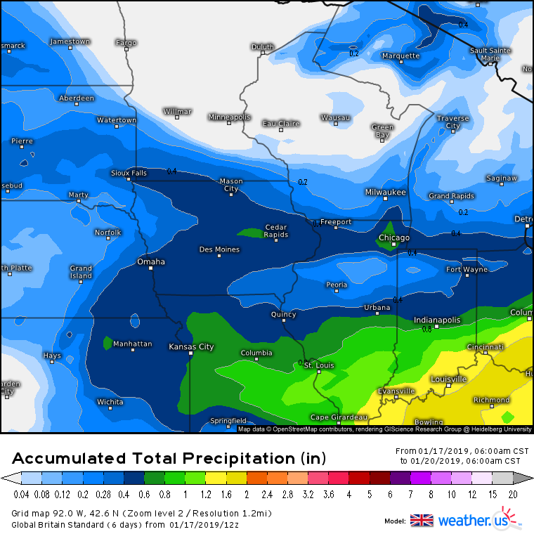
12z UK... Clearly, still some large differences between the models. Some have the heavier stuff in far north and south Iowa, with a dry hole in between, while the UK is the inverse.
-
Jan 18th-20th Potential Winter Storm. Can this be The One??
Hawkeye replied to jaster220's topic in East of the Rockies
12z Canadian is much better for Iowa, strongly disagreeing with the dry moat through sw/central Iowa. -
Jan 18th-20th Potential Winter Storm. Can this be The One??
Hawkeye replied to jaster220's topic in East of the Rockies
12z FV3 is terrible.... worst run so far, huge dry moat across Iowa, -
Jan 18th-20th Potential Winter Storm. Can this be The One??
Hawkeye replied to jaster220's topic in East of the Rockies
So far this morning, every model has been a step back for Cedar Rapids. We may have to settle for 0.25-0.35" qpf. -
Jan 18th-20th Potential Winter Storm. Can this be The One??
Hawkeye replied to jaster220's topic in East of the Rockies
Initial impression of the ICON is not good at all.... just keeps shooting the system through more quickly, now has the initial fgen band way up in far northern Iowa. -
Jan 18th-20th Potential Winter Storm. Can this be The One??
Hawkeye replied to jaster220's topic in East of the Rockies
This is why you can't lock in any nam run. It's just too inconsistent. The 12z is a big step back for central Iowa. While central to sw Iowa goes from wet pocket to dry pocket, far southeast Iowa into northern Illinois goes from dry to wet. It's impossible to buy it when it fluctuates so wildy. -
January 2019 Observations and Discussion
Hawkeye replied to Minny_Weather's topic in East of the Rockies
We are not seeing any precip at all in Cedar Rapids. -
Jan 18th-20th Potential Winter Storm. Can this be The One??
Hawkeye replied to jaster220's topic in East of the Rockies
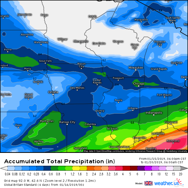
00z UK... obviously, I'd love this
-
Jan 18th-20th Potential Winter Storm. Can this be The One??
Hawkeye replied to jaster220's topic in East of the Rockies
00z FV3.... not much change -
Jan 18th-20th Potential Winter Storm. Can this be The One??
Hawkeye replied to jaster220's topic in East of the Rockies
The Canadian is the only model that shows the initial band of snow streaking through central Iowa rather than northern Iowa. -
Jan 18th-20th Potential Winter Storm. Can this be The One??
Hawkeye replied to jaster220's topic in East of the Rockies
The GFS is why I don't buy the NAM. -
Jan 18th-20th Potential Winter Storm. Can this be The One??
Hawkeye replied to jaster220's topic in East of the Rockies
00z ICON.... still has the big moat. -
Jan 18th-20th Potential Winter Storm. Can this be The One??
Hawkeye replied to jaster220's topic in East of the Rockies
Des Moines NWS mentioned in their afternoon discussion that the northern Iowa band of snow should have pretty high ratios. -
Jan 18th-20th Potential Winter Storm. Can this be The One??
Hawkeye replied to jaster220's topic in East of the Rockies
The NAM is fantastic. However, I still need to see other models join it. It's a bad idea to jump on a couple wet nam runs just because they are good for my yard. The 3k nam shows a very heavy band lifting from southern Iowa up through Cedar Rapids. I don't buy it. -
January 2019 Observations and Discussion
Hawkeye replied to Minny_Weather's topic in East of the Rockies
Euro had two straight runs with a blizzard next week for the western lakes. This morning's run, nada... just a weaker system passing south. -
Jan 18th-20th Potential Winter Storm. Can this be The One??
Hawkeye replied to jaster220's topic in East of the Rockies
Multiple models are spitting out 0.60+" qpf in that band streaking through northern Iowa. With good ratios, that's a darn good storm. We just need that to edge south a bit. -
Jan 18th-20th Potential Winter Storm. Can this be The One??
Hawkeye replied to jaster220's topic in East of the Rockies
12z UK
-
Jan 18th-20th Potential Winter Storm. Can this be The One??
Hawkeye replied to jaster220's topic in East of the Rockies
12z Canadian... farther south with the northern wave than other models. -
Jan 18th-20th Potential Winter Storm. Can this be The One??
Hawkeye replied to jaster220's topic in East of the Rockies
12z FV3 is a bit of an improvement as well. The moat has filled in some. -
Jan 18th-20th Potential Winter Storm. Can this be The One??
Hawkeye replied to jaster220's topic in East of the Rockies
A couple of these models are quite far north with that initial wave. -
Jan 18th-20th Potential Winter Storm. Can this be The One??
Hawkeye replied to jaster220's topic in East of the Rockies
LOL. Some of the snow maps being spit out by the models are amusingly patchy. -
Jan 18th-20th Potential Winter Storm. Can this be The One??
Hawkeye replied to jaster220's topic in East of the Rockies
Well, the models are still suggesting there could be a pretty nice band of snow somewhere in Iowa. Each model streaks that initial band out across Iowa a bit differently, some north of CR, some over CR. 3-6" is still possible. Heck, the new ICON spits out 0.75" in Waterloo... likely overdone, but. -
Jan 18th-20th Potential Winter Storm. Can this be The One??
Hawkeye replied to jaster220's topic in East of the Rockies
00z UK
-
Jan 18th-20th Potential Winter Storm. Can this be The One??
Hawkeye replied to jaster220's topic in East of the Rockies
I noticed that, too. There has been a lot of talk about a super cold NFL game on Sunday in KC, with a high temp in the single digits. However, this evening's 00z GFS run has the temp in the 20s. -
Jan 18th-20th Potential Winter Storm. Can this be The One??
Hawkeye replied to jaster220's topic in East of the Rockies
Yeah, that seems to be the trend. It's like the energy moves into the west and then falls into a hole.