Hawkeye
-
Posts
7166 -
Joined
-
Last visited
-
Days Won
17
Everything posted by Hawkeye
-
Congrats, Chicagoland. It appears I'll be watching this one from the sideline.
-
NAM jumping back south
-
Yeah, the GFS will likely begin sagging south this evening.
-
Well, that's a bummer from the euro.
-
It appears the FV3-GFS is also going to be back north a bit. Over the last day of runs, the Canada upper low dipped noticeably farther south the first couple runs, but the last two it's being pulled back north.
-
We didn't even fall below the low 40s this morning.
-
00z UK
-
That upper low to the north is killing us. The FV3 finally caved and now pokes it much farther south. I hope the models have that feature wrong.
-
Today was the first above avg day this month in Cedar Rapids. We're still trying to melt off the last of the 2.7" of snow that fell last Saturday morning. It's not easy to keep a small amount on the ground for a week in November.
-
Frankly, I think the FV3 is overdoing it a bit. It's very wrapped up with a 989 mb low, several mb lower than the euro. A bit farther south and not as strong is more likely.
-
FV3-GFS still very different than the regular GFS. The FV3 just doesn't have that upper low to the north dipping down into the US like the GFS does, which allows Iowa to get nailed. In fact, the FV3 has moved a bit farther north and misses CR to the nw with the best snow. BTW, my posting will continue to be inconsistent and perhaps sparse because of computer issues.
-
The big upper gyre in southern Canada keeps progressing farther south and east on the GFS, ends up squashing the storm south and east. It would really be something to have three big snow events miss me to the south in November.
-
Yes, it's QPF that falls as snow.
-
12z euro.... This run is quick and south. The quickness doens't allow all the warm air to get pulled up into Iowa, but then that keeps all the precip farther se.
-
North-central Iowa crashed to around -6 degrees this morning. Wow! The Cedar Rapids airport hit 9, while it was about 12 here.
-
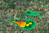
The winners, yesterday, were a couple towns west of Ottumwa, where up to 7.5" fell.
-
There's a report of near 7 inches just west of Ottumwa. Wow, that band really snuck up and overperformed. The NWS was totally caught by surprise.
-
I picked up 2.7 inches from 0.29" liquid. I woke up a couple times overnight and looked out the bedroom window, but the visibility was no big deal so I just went back to sleep. If it's snowing overnight, it needs to be heavy or I just don't care anymore.
-
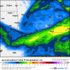
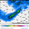
The 20z HRRR had a 0.50" strip through CR. However, the last three runs have dried out a fair amount. The latest is down to about 0.30".
-
Two local mets are keeping the better snow along and north of Waterloo-Dubuque. One of them still has Cedar Rapids in the T-1" band. The other, Terry Swails, has the good band a little farther south, with 2-4 reaching down to near CR. He said given the latest model data, he would extend the advisory farther south if he was in charge.
-
18z GFS continues the southward sag.
-
Welcome, BMT! I wish the guy from southwest Johnson county would join us as well. Dang... the latest HRRR is super juiced, has a 0.50" strip through CR.
-
DVN is expanding the advisory, but only down to Waterloo/Dubuque. They must be skeptical of the farther south snow placement.
-
Yeah, it's getting more interesting for the CR area. The HRRR is showing some pretty good snow rates from 2-5am.
-
I see the nws is pretty unexcited about this system for anyone outside of northeast Iowa. DVN has