Brian_in_Leavenworth
-
Posts
3545 -
Joined
-
Last visited
-
Days Won
7
Everything posted by Brian_in_Leavenworth
-

December Weather In the PNW
Brian_in_Leavenworth replied to BLI snowman's topic in West of the Rockies
Here is the 48 hour trend. 48 hours ago the GFS ensemble had the ridge parked right over us.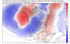
-
December Weather In the PNW
Brian_in_Leavenworth replied to BLI snowman's topic in West of the Rockies
What "phases" are those? -
December Weather In the PNW
Brian_in_Leavenworth replied to BLI snowman's topic in West of the Rockies
You can get that same map for free at wx.graphics http://wx.graphics/models/ecmwf/ecmwf_usa.php Go to 9k USA surface on the left side, 2nd one down. Then select Washington (or Oregon, or whatever state), then go to hour 240, or whatever hour, and select snowfall. Or any of a number of parameters.
-
December Weather In the PNW
Brian_in_Leavenworth replied to BLI snowman's topic in West of the Rockies
NWS Seattle recorded 70 at the Humptullips weather station in the Olympics. -
December Weather In the PNW
Brian_in_Leavenworth replied to BLI snowman's topic in West of the Rockies
Seemed like after the 1st down after the facemask penalty, they were more concerned about running out the clock or not throwing an interception rather than trying for a touchdown -
December Weather In the PNW
Brian_in_Leavenworth replied to BLI snowman's topic in West of the Rockies
That's when we will SCORE!! -
December Weather In the PNW
Brian_in_Leavenworth replied to BLI snowman's topic in West of the Rockies
Yup. That is why when we wake up tomorrow, we had to go 10 days forward to Dec. 20th. Seriously, why can't they hire a guy who is great with time management, situational management, when to challange calls, etc.? Someone to tell him "take the 3 points now, we may need them at the end of the game". So many times they didn't kick the field goal at the end of the 1st half and later on wished they had, or wished they had not blown a time out on an obviously correct ref's call? -
December Weather In the PNW
Brian_in_Leavenworth replied to BLI snowman's topic in West of the Rockies
And don't forget, since we are in the last month of the year and we have no timeouts, a 10 day rundown. Christmas is next week! -
December Weather In the PNW
Brian_in_Leavenworth replied to BLI snowman's topic in West of the Rockies
Right at the end of the run the 18Z is starting to look interesting. Ridge over us and BC starts to retrograde and merge with another ridge around the Aleutians. -
December Weather In the PNW
Brian_in_Leavenworth replied to BLI snowman's topic in West of the Rockies
Yeah but that is 10AM, temps in the 30's for Western Washington and Oregon that time of day is not that cold. -
December Weather In the PNW
Brian_in_Leavenworth replied to BLI snowman's topic in West of the Rockies
The GFS did not listen to Phil. -
December Weather In the PNW
Brian_in_Leavenworth replied to BLI snowman's topic in West of the Rockies
Apparently you have not seen the last few model runs. Not that any of them are real accurate that far in advance anyway. -
December Weather In the PNW
Brian_in_Leavenworth replied to BLI snowman's topic in West of the Rockies
Yeah, I thought that they ran CFS ensembles like they did the GFS and Euro ensembles. I found this at the NOAA site: "How many CFS forecasts should be combined into an ensemble? Because climate runs are done daily from different sets of initial conditions, we can combine the different runs to give an ensemble of climate forecasts. Multiple climate runs allow climate forecasters to obtain probabilities for seasonal precipitation and temperature anomalies. Given the uncertainty in climate forecasts, this is a natural application of the ensemble method. The CPC uses around 40 CFS forecasts to obtain reasonable climate forecast probabilities and a good ensemble mean climate forecast." Tropical Tidbits does their weekly based on 48 forecasts, or 12 days. That other web site does it over 5 days, or 20 runs. CPS says 40 runs or 10 days, but I wonder if that is for the monthlies, not the weeklies. And I think the above statement was written several years ago, before version 2, and maybe before they even did the weeklies. Anyway, regardless of number, now we know how they do their ensembles. -
December Weather In the PNW
Brian_in_Leavenworth replied to BLI snowman's topic in West of the Rockies
I did find an interesting web site for CFS ensembles, and I looked up the guys name who runs it, and he is a "Science & Operations Officer at NOAA/National Weather Service", so it is a legit site, even though it is not a .gov site. http://cfs.hopwrf.info/ Good tools there, lots of maps. It says " The output on this site is based on a 20-member ensemble generated from the four daily CFS control runs (00, 06, 12, & 18 UTC) over the past five days. Output is updated as each cycle is processed, and is typically available approximately 15 hours after cycle time (e.g. output which includes the latest 00 UTC run is available around 15 UTC)."
-
December Weather In the PNW
Brian_in_Leavenworth replied to BLI snowman's topic in West of the Rockies
At the wx.graphics site, they have the CFS monthlies, and from there, you can go to the "last 25 stamps" and see the trend. But I don't think it is emsembles, probably the operational. -
December Weather In the PNW
Brian_in_Leavenworth replied to BLI snowman's topic in West of the Rockies
Again those are the ensembles? The "operational" or control run or whatever that is has been showing warm for most of the last week or runs. -
December Weather In the PNW
Brian_in_Leavenworth replied to BLI snowman's topic in West of the Rockies
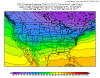
12Z followed the trend of the ensembles and parked the big ridge right over us around Christmas -
December Weather In the PNW
Brian_in_Leavenworth replied to BLI snowman's topic in West of the Rockies
Well, the Canadian long term ensembles and the 6z EPS also trended that way. Hopefully Phil will give his thoughts. And you could be right, maybe some bad initial data or something. Seems to go against all the recent trends. -
December Weather In the PNW
Brian_in_Leavenworth replied to BLI snowman's topic in West of the Rockies
Ridge by the Alluetians looks stronger than 18Z -
December Weather In the PNW
Brian_in_Leavenworth replied to BLI snowman's topic in West of the Rockies
1990 there too. -
December Weather In the PNW
Brian_in_Leavenworth replied to BLI snowman's topic in West of the Rockies
Yeah, thanks for the correction. So far the ensembles not looking as dramatic. -
December Weather In the PNW
Brian_in_Leavenworth replied to BLI snowman's topic in West of the Rockies
SE ridge is there too. I think Flatiron said that the perception is that the SE ridge helps keep the pattern more stable. -
December Weather In the PNW
Brian_in_Leavenworth replied to BLI snowman's topic in West of the Rockies

-
December Weather In the PNW
Brian_in_Leavenworth replied to BLI snowman's topic in West of the Rockies
Phil, saw this twitter yesterday. Interpretation would be helpful. Sounds like he is saying that at some point the polar vortex could get dislodged again later in December, and at that point, we could be in the sweet spot, though he did not talk about that. Judah Cohen @judah47 Dec 7 MoreGFS is also growing more confident in a robust pulse of WAFz/poleward heat transport for mid-December. Needs to be watched but at a minimum it will perturb the #PolarVortex for a second time this December.
-
December Weather In the PNW
Brian_in_Leavenworth replied to BLI snowman's topic in West of the Rockies
Last nights ensembles had the ridge parked a little too close to us, so this looks better.