

Brian_in_Leavenworth
-
Posts
3545 -
Joined
-
Last visited
-
Days Won
7
Everything posted by Brian_in_Leavenworth
-

January 2019 Weather in the Pacific Northwest
Brian_in_Leavenworth replied to Requiem's topic in West of the Rockies
Yup. It is amazing how many people believe in jinxes. Like people who think s potential no-hitter is jinxed if the announcer says a no-hitter is going on. -
January 2019 Weather in the Pacific Northwest
Brian_in_Leavenworth replied to Requiem's topic in West of the Rockies
It was the weekend of the BeastQuake game. That game was played on a Saturday, AFD talked about major snowstorms hitting, probably similar to 1996 in that you had the cold air to the north with storms coming in. 1996 the original forecast has the storms going north, bringing in the warm air, until a few days before and the storms did not go as far north, and the region had major snow. Anyway, 2011 it was supposed to be in the Tuesday-Thursday time frame. I went to bed Saturday evening with visions of a major snow, woke up to watch the Sunday morning news, and they were advertising rain for Tuesday through Wednesday, as the storms ending up going North. IIRC, the NAM was the first to pick up on the north trend. So it was really about 3 days out. -
January 2019 Weather in the Pacific Northwest
Brian_in_Leavenworth replied to Requiem's topic in West of the Rockies
Here is Bret Anderson: Chilly, but dry. -
January 2019 Weather in the Pacific Northwest
Brian_in_Leavenworth replied to Requiem's topic in West of the Rockies
I was wondering about last nights Euro Weeklies. They can be confusing, as I have seen people interpret the same maps differently, but here is one interpretation from this site: https://weatherloverblog.wordpress.com/2019/01/29/jan-28-euro-weeklies/ This set of imagery depicts most of February. -
January 2019 Weather in the Pacific Northwest
Brian_in_Leavenworth replied to Requiem's topic in West of the Rockies
Just wondering if any of the past weeklies showed westside snow on that same graph. Haven't seen a comparison. Even the previous weeklies probably had a few rogue snowy members skewing the results and the mean. Would like to see the 500mbs. -
January 2019 Weather in the Pacific Northwest
Brian_in_Leavenworth replied to Requiem's topic in West of the Rockies
That, from Ventrice, is actually the difference between the previous weeklies and the new one. Previous weeklies had the west quite warm, so this means it is showing normal temps for week 3, as earlier predicted by Ventrice. Dont know about the other weeks though -
January 2019 Weather in the Pacific Northwest
Brian_in_Leavenworth replied to Requiem's topic in West of the Rockies
Michael VentriceVerified account @MJVentrice 3h3 hours ago MoreInteresting twist... Models are trending in favor of a robust -PNA. For what the PNA loading pattern looks like: https://www.cpc.ncep.noaa.gov/products/precip/CWlink/pna/pna.loading.shtml … -
January 2019 Weather in the Pacific Northwest
Brian_in_Leavenworth replied to Requiem's topic in West of the Rockies
Earlier today you said it's over. Then after a good run you said "Book it". Now you say "Its over". All in 12 hours. Are you really that much of a model rider, in which case that is sad because you have been around long enough to know better, or so you just like to joke around? Just curious. -
January 2019 Weather in the Pacific Northwest
Brian_in_Leavenworth replied to Requiem's topic in West of the Rockies
He's not talking about the PNW, he is talking about the East. The pattern is similar to that which produced the 1993 superstorm, not the 1993 arctic blast for us. The maps he posted shows nothing close to the PNW. -
January 2019 Weather in the Pacific Northwest
Brian_in_Leavenworth replied to Requiem's topic in West of the Rockies
-
January 2019 Weather in the Pacific Northwest
Brian_in_Leavenworth replied to Requiem's topic in West of the Rockies
Usually it is the arctic air that misses us by a thousand miles. -
January 2019 Weather in the Pacific Northwest
Brian_in_Leavenworth replied to Requiem's topic in West of the Rockies
-
January 2019 Weather in the Pacific Northwest
Brian_in_Leavenworth replied to Requiem's topic in West of the Rockies
I would be surprised if they just let all the water during a known El Nino winter. In Washington they definitely do not. They are very well aware of the predictions of warmer and drier weather for the rest of winter, and plan accordingly. -
January 2019 Weather in the Pacific Northwest
Brian_in_Leavenworth replied to Requiem's topic in West of the Rockies
I remember sitting at Fenway down the right field line, and the seat was facing toward center field. Got a sore neck from having to keep my head turned far to the left for 9 innings. Still worth going once for the history and my first major league game that was actually outdoors. -
January 2019 Weather in the Pacific Northwest
Brian_in_Leavenworth replied to Requiem's topic in West of the Rockies
That was from yesterday. Today's comes out at 1 -
January 2019 Weather in the Pacific Northwest
Brian_in_Leavenworth replied to Requiem's topic in West of the Rockies
That is a nice thing about living in snow country. They actually plow the roads, and the only real problem I have is my driveway, though I have snow tires and an all wheel drive car. During a snowstorm the roads can get a bit snowy, but they are good at plowing and the roads never have snow on them for very long. OTOH, when I lived in Western Washington, they did not plow the roads, they just put sand on them, which doesn't help a lot and just gets sand all over the place. -
January 2019 Weather in the Pacific Northwest
Brian_in_Leavenworth replied to Requiem's topic in West of the Rockies
GFS has changed a lot since then, it is now run at a higher resolution, and the resolution change happens later. Also professional forecasters use the ensemble mean for forecasting beyond a week. -
January 2019 Weather in the Pacific Northwest
Brian_in_Leavenworth replied to Requiem's topic in West of the Rockies
Courtesy of Dr. Maue, here is the first two weeks of February according to today's Euro weeklies run:
-
January 2019 Weather in the Pacific Northwest
Brian_in_Leavenworth replied to Requiem's topic in West of the Rockies
There goes the 18Z myth again. Every expert says that the 18Z and 6Z runs are not any worse than the 0z or 12Z runs. The problem is not that it is the 18Z, the problem is that it is the GFS. OTOH,it has been scoring better lately. -
January 2019 Weather in the Pacific Northwest
Brian_in_Leavenworth replied to Requiem's topic in West of the Rockies
In the really long run, might be the best ensemble mean yet. -
January 2019 Weather in the Pacific Northwest
Brian_in_Leavenworth replied to Requiem's topic in West of the Rockies
If the GFS only went out to 288 hours, we would never be teased by the day 15 and 16 arctic blasts. And nobody would get their hopes up too high. -
January 2019 Weather in the Pacific Northwest
Brian_in_Leavenworth replied to Requiem's topic in West of the Rockies
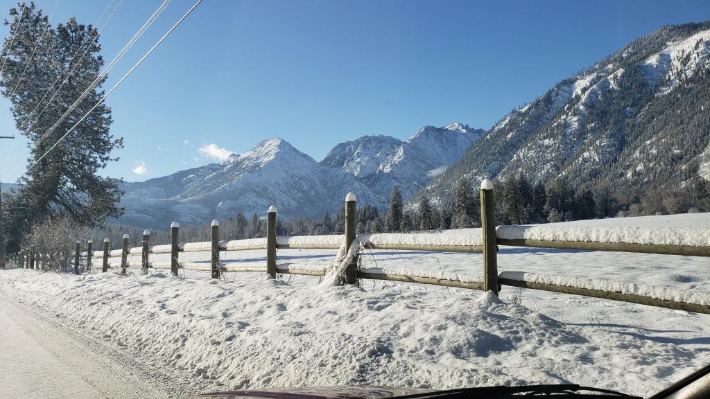
Not surprising at all that the snowpack around here would be doing ok on January 17th. Last Nino a few years ago snowpack was above normal at this time of year. In town we had a snowy December and early January. It is what happens after mid January that is the worry. Historically, things really dry up from this point on during El Nino. Here in town we have a base of 13". Have had one really good snow last week (10+ inches in two days), and then about 4 inches overnight and this morning. Might be the last for awhile. -
January 2019 Weather in the Pacific Northwest
Brian_in_Leavenworth replied to Requiem's topic in West of the Rockies
An improvement for sure, but Like DJ said, a long ways to go. -
January 2019 Weather in the Pacific Northwest
Brian_in_Leavenworth replied to Requiem's topic in West of the Rockies
Finer details are the difference between snow and rain. Looks chilly but not arctic. -
January 2019 Weather in the Pacific Northwest
Brian_in_Leavenworth replied to Requiem's topic in West of the Rockies
Low 40's for the Portland area. Above freezing in Puget Sound too. Not sure what makes it so exciting for Western WA and OR?

