gabel23
-
Posts
2304 -
Joined
-
Last visited
-
Days Won
5
Everything posted by gabel23
-

February 2022 Observations and Discussions
gabel23 replied to Grizzcoat's topic in East of the Rockies
Well at least there is a little action in Nebraska. Snow Squall Warning SNOW SQUALL WARNING NWS NORTH PLATTE NE 1046 AM CST FRI FEB 11 2022 NEC009-041-115-111715- /O.NEW.KLBF.SQ.W.0003.220211T1646Z-220211T1715Z/ 1046 AM CST FRI FEB 11 2022 Blaine County-Custer County-Loup County- The National Weather Service in North Platte has issued a * Snow Squall Warning for... Southwestern Loup County in north central Nebraska... Northeastern Custer County in central Nebraska... Blaine County in north central Nebraska... * Until 1115 AM CST. * At 1045 AM CST, a dangerous snow squall was located along a line extending from 10 miles north of Dunning to 6 miles south of Brewster to 12 miles northwest of Taylor, moving southeast at 35 mph. HAZARD...Poor visibility in snow and blowing snow. Wind gusts greater than 30 mph. -
February 2022 Observations and Discussions
gabel23 replied to Grizzcoat's topic in East of the Rockies
Then meanwhile yet another Blizzard warning for the Red River Valley of the North. Has to be pushing double digits by now for them; just a wonderful winter up there. URGENT - WINTER WEATHER MESSAGE National Weather Service Grand Forks ND 1252 PM CST Thu Feb 10 2022 MNZ001-002-004-007-NDZ008-016-027-029-030-111500- /O.CAN.KFGF.WW.Y.0015.000000T0000Z-220210T2200Z/ /O.NEW.KFGF.BZ.W.0006.220211T0300Z-220211T1500Z/ West Polk-Norman-Kittson-West Marshall-Pembina-Eastern Walsh- Grand Forks-Steele-Traill- Including the cities of Crookston, East Grand Forks, Ada, Twin Valley, Halstad, Hallock, Karlstad, Lancaster, Warren, Stephen, Argyle, Cavalier, Walhalla, Drayton, Pembina, Neche, St. Thomas, Grafton, Park River, Grand Forks, Finley, Hope, Mayville, Hillsboro, Hatton, and Portland 1252 PM CST Thu Feb 10 2022 ...BLIZZARD WARNING IN EFFECT FROM 9 PM THIS EVENING TO 9 AM CST FRIDAY... ...WINTER WEATHER ADVISORY IS CANCELLED... * WHAT...Blizzard conditions expected. Total snow accumulations of up to one inch. Winds gusting as high as 55 mph. * WHERE...Portions of northwest Minnesota and northeast and southeast North Dakota. * WHEN...From 9 PM this evening to 9 AM CST Friday. * IMPACTS...Plan on slippery road conditions as temperatures fall rapidly. Widespread blowing snow will significantly reduce visibility. The hazardous conditions could impact the morning commute. Dangerously cold wind chills as low as 30 below zero could cause frostbite on exposed skin in as little as 10 minutes. * ADDITIONAL DETAILS...Strong north winds combined with falling snow will lead to whiteout conditions during the overnight period and into Friday morning. These conditions could last into early Friday afternoon if snow showers persist. PRECAUTIONARY/PREPAREDNESS ACTIONS... Travel should be restricted to emergencies only. If you must travel, have a winter survival kit with you. If you get stranded, stay with your vehicle. The latest road conditions for North Dakota can be found at dot.nd.gov/travel and for Minnesota at 511mn.org, or by calling 5 1 1 in either state. -
February 2022 Observations and Discussions
gabel23 replied to Grizzcoat's topic in East of the Rockies
Euro and GFS both picking up on the next possible storm to track. This one I would hope has Nebraska's name on it. This is the storm I have been waiting for since two cycles back. -
February 2022 Observations and Discussions
gabel23 replied to Grizzcoat's topic in East of the Rockies
I heard from a guy that goes to our church he saw some trees budding. Pretty bizarre winter; by far the warmest and driest in recent memory. Only other ones that come to mind is the winters of 2011-12 and 2012-13. We had a major blizzard in the December of 2012 winter at least. The 11-12 year we went into a major drought that summer. -
2/1 - 2/3 MW/Lower Lakes Major Winter Storm (GHD-3)
gabel23 replied to Tom's topic in East of the Rockies
Well then that stinks. Just get rid of that dry air to the north and throw us a bone. Lots of time for this to change I know but things look like they have been for my area all year. Missed to the south and east. Hoping for a GFS win on this one. -
Man that's awesome! Have you ever seen a set up like this before?! I don't recall Chicago getting much lake effect snow outside of storm systems causing lake enhancement.
-
I'm a die hard bills fan so I had to respond with the puke emoji........it still hurts.
-
2/1 - 2/3 MW/Lower Lakes Major Winter Storm (GHD-3)
gabel23 replied to Tom's topic in East of the Rockies
This has suppression written all over it. Way early in the game but I see this thing missing my area to the south and east. I have been missed all year and I would expect that trend to continue. I just hope we can all cash in with at least a little snow! -
Is this Craig posting?! LMAO! I had a colleague ask me about all this hype about the polar vortex striking our area next week.
-
February 2022 Observations and Discussions
gabel23 replied to Grizzcoat's topic in East of the Rockies
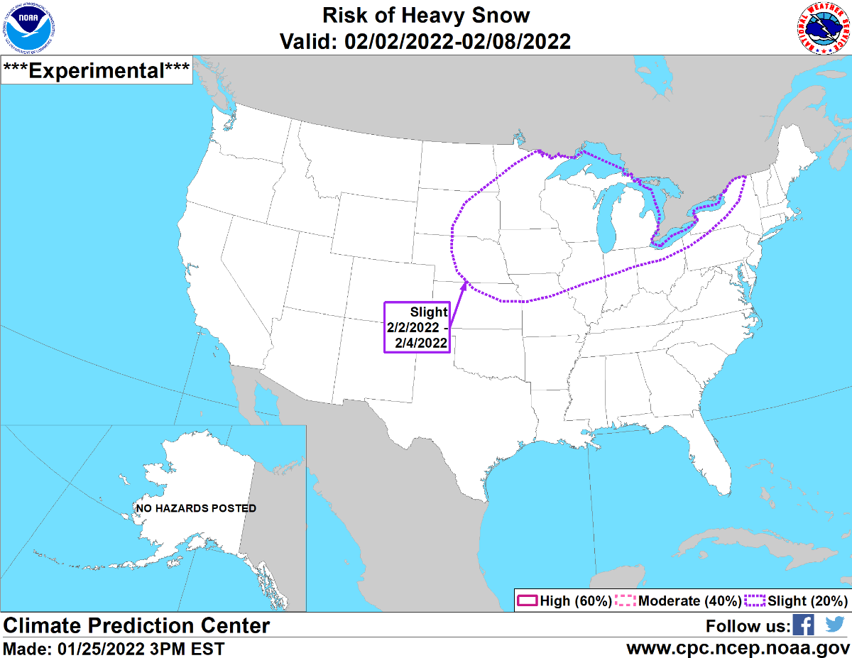
I got my eyes on the Feb. 10th-Feb. 16th time frame. The december part of the pattern is due in then. That's the part of the pattern where we seen a tornado outbreak in the midwest. That's if the LRC is in fact on a 60 day cycle. -
2/1 - 2/3 MW/Lower Lakes Major Winter Storm (GHD-3)
gabel23 replied to Tom's topic in East of the Rockies
I think they go directly off of what the ensembles are showing. Typically if there is good consensus they will do this; I have also seen it shift around a lot! -
2/1 - 2/3 MW/Lower Lakes Major Winter Storm (GHD-3)
gabel23 replied to Tom's topic in East of the Rockies
Kiss of death the CPC.
-
2/1 - 2/3 MW/Lower Lakes Major Winter Storm (GHD-3)
gabel23 replied to Tom's topic in East of the Rockies
What are the chances we just get a more west/east based track versus the darn cutting?! Just one time please; that tends to share the wealth more and all year long cutter's haven't been good for me. Teleconnections are all right around neutral you would think that would help. -
Interesting, convective snow rolls causing the snow?! WTH is that?? This is from the NWS up there. increasing winds, winds gusting over to 50 mph is expected to push into the southern valley and temps falling into the single digits along with horizontal convective rolls are producing snow showers and based on satellite trends, have increased in coverage, pushing into the central valley. Unless snow streamers or HCRs are moving overhead the blizzard conditions are in the primarily for open country. Across SE ND winds have coupled and are mixing stronger 850mb winds down to the sfc with 58mph measured at Valley City this past hour.
-
My mini blizzard. IMG_1613.MOV
-
Should be a snow squall warning for my area. Just ripping in this band!!

-
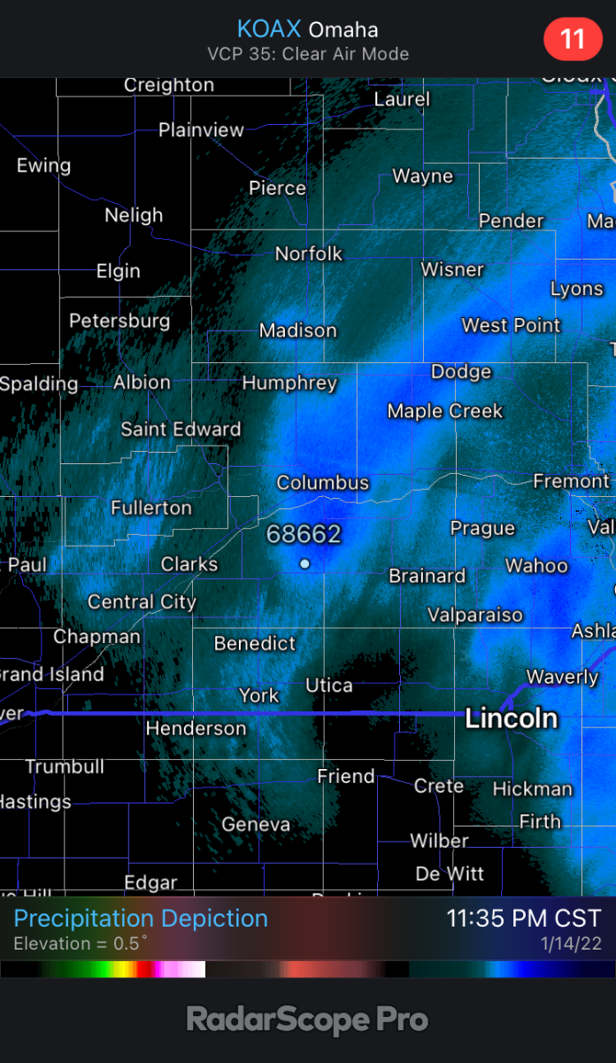
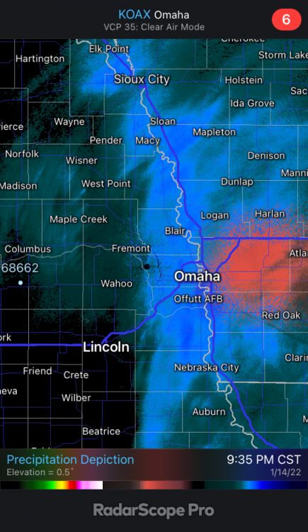
Almost looks like river effect snow going on along the Missouri. I’m telling you a study needs to be done on the affects of rivers and weather!
-
The tornado outbreak is due in around Valentine’s Day; that’s how I’m gonna judge the LRC this year. If you go by the 60-65 day cycle, which I think Gary mentioned was this years range, would give my area the best chance at a major system. Insane what a year makes, last year at this time had a total of 15” of snow. This year I’m sitting at 2”! We had a lot of northwest flow in November; that’s what is showing up in the long range….
-
Patchy blue skies over here and plenty of wind. I'll keep you guys updated I might see a snow flake or two. Seriously though; enjoy Iowa peeps what a nice bullseye clipper for the state.
-
As I mentioned yesterday; pretty amazing how close the models are lining up with what the flow was like in 1993!
-
How about now!! Ha! URGENT - WINTER WEATHER MESSAGE National Weather Service Des Moines IA 1012 AM CST Wed Jan 12 2022 ...Winter Storm to Impact the Area Friday through Late Friday Night... .A winter storm with the potential for moderate to heavy snow accumulations will affect the area Friday into late Friday night. The snow is expected to cause impacts on travel especially the evening commute. Winds of 10 to 20 mph with gusts to 30 mph will produce blowing and drifting snow. IAZ004-005-015-023>025-033>037-044>049-057>061-070>075-081>086- 092>097-130015- /O.NEW.KDMX.WS.A.0001.220114T1500Z-220115T1200Z/ Emmet-Kossuth-Palo Alto-Pocahontas-Humboldt-Wright-Sac-Calhoun- Webster-Hamilton-Hardin-Crawford-Carroll-Greene-Boone-Story- Marshall-Audubon-Guthrie-Dallas-Polk-Jasper-Cass-Adair-Madison- Warren-Marion-Mahaska-Adams-Union-Clarke-Lucas-Monroe-Wapello- Taylor-Ringgold-Decatur-Wayne-Appanoose-Davis- Including the cities of Estherville, Algona, Emmetsburg, Pocahontas, Laurens, Rolfe, Fonda, Gilmore City, Humboldt, Eagle Grove, Clarion, Belmond, Sac City, Lake View, Odebolt, Wall Lake, Schaller, Early, Rockwell City, Manson, Lake City, Pomeroy, Fort Dodge, Webster City, Iowa Falls, Eldora, Ackley, Denison, Carroll, Jefferson, Boone, Ames, Marshalltown, Audubon, Exira, Guthrie Center, Panora, Bayard, Casey, Perry, Waukee, Adel, Des Moines, Newton, Atlantic, Greenfield, Stuart, Adair, Fontanelle, Winterset, Earlham, Indianola, Norwalk, Carlisle, Pella, Knoxville, Oskaloosa, Corning, Creston, Osceola, Chariton, Albia, Ottumwa, Bedford, Lenox, New Market, Mount Ayr, Lamoni, Leon, Corydon, Seymour, Allerton, Humeston, Centerville, and Bloomfield 1012 AM CST Wed Jan 12 2022 ...WINTER STORM WATCH IN EFFECT FROM FRIDAY MORNING THROUGH LATE FRIDAY NIGHT... * WHAT...Heavy snow possible. Total snow accumulations of 4 to 8 inches possible. Locally higher amounts likely. * WHERE...Central Iowa. * WHEN...From Friday morning through late Friday night. * IMPACTS...Travel could be very difficult. The hazardous conditions will impact the evening commute. Easterly winds of 10 to 20 mph with gusts to 30 mph will produce blowing and drifting snow.
-
Well said. I never knew about the track staying along the ocean. Typically clippers tend to be along a continental air mass not a maritime one. Models started with a west trend and hopefully now a more juiced one will follow! One thing for sure; I don’t recall a clipper digging that far southeast and then turning into a monster nor’easter. Only one I can recall is the superstorm of 93. That one started in Florida and cut up though.
-
Got excited for a bit this morning; looks like it's gonna be another sharpe edge for me. Same for all the storms in my area so far this year. I have been on the edge in every direction; this one will make it the first time on the western edge of a storm.
-
What’s your snow depth??
-
Nothing worse than brown grass and wind chills of -20! That's what we have; just not a good year for my area! Hopefully things change moving forward!